
No Mesoscale Discussions are in effect as of Fri Apr 19 06:15:07 UTC 2024. Read More
SPC Apr 19, 2024 0600 UTC Day 2 Convective Outlook

SPC 0600Z Day 2 Outlook Day 2 Convective Outlook NWS Storm Prediction Center Norman OK 1255 AM CDT Fri Apr 19 2024 Valid 201200Z – 211200Z …THERE IS A MARGINAL RISK OF SEVERE THUNDERSTORMS ACROSS PARTS OF SOUTH-CENTRAL AND SOUTHEAST TEXAS… …SUMMARY… Marginally severe storms capable of strong wind gusts and hail will be possible …
Continue reading SPC Apr 19, 2024 0600 UTC Day 2 Convective Outlook
SPC Apr 19, 2024 0600 UTC Day 1 Convective Outlook

SPC 1200Z Day 1 Outlook Day 1 Convective Outlook NWS Storm Prediction Center Norman OK 1245 AM CDT Fri Apr 19 2024 Valid 191200Z – 201200Z …THERE IS A MARGINAL RISK OF SEVERE THUNDERSTORMS ACROSS PORTIONS OF THE SOUTHEASTERN US… …SUMMARY… Sporadic strong to marginally severe storms are possible over parts of the Southeast later …
Continue reading SPC Apr 19, 2024 0600 UTC Day 1 Convective Outlook
SPC Severe Thunderstorm Watch 130 Status Reports
WW 0130 Status Updates STATUS REPORT ON WW 130 SEVERE WEATHER THREAT CONTINUES RIGHT OF A LINE FROM 25 SE RUE TO 35 N LIT TO 30 SSW PAH. ..KERR..04/19/24 ATTN…WFO…LZK…MEG… STATUS REPORT FOR WS 130 SEVERE WEATHER THREAT CONTINUES FOR THE FOLLOWING AREAS ARC031-037-045-067-085-093-111-117-119-145-147-190640- AR . ARKANSAS COUNTIES INCLUDED ARE CRAIGHEAD CROSS FAULKNER JACKSON …
Continue reading SPC Severe Thunderstorm Watch 130 Status Reports
SPC Severe Thunderstorm Watch 129 Status Reports
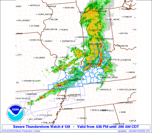
WW 0129 Status Updates STATUS REPORT ON WW 129 SEVERE WEATHER THREAT CONTINUES RIGHT OF A LINE FROM 35 NNW DYR TO 35 NNW HOP TO 25 SE OWB. ..KERR..04/19/24 ATTN…WFO…PAH…ILX…IND…LMK… STATUS REPORT FOR WS 129 SEVERE WEATHER THREAT CONTINUES FOR THE FOLLOWING AREAS KYC031-035-047-061-075-083-085-093-105-141-143-157-177-183-213- 219-221-227-190640- KY . KENTUCKY COUNTIES INCLUDED ARE BUTLER CALLOWAY CHRISTIAN …
Continue reading SPC Severe Thunderstorm Watch 129 Status Reports
SPC MD 492
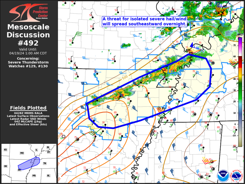
MD 0492 CONCERNING SEVERE THUNDERSTORM WATCH 129…130… FOR NORTH-CENTRAL/NORTHEAST AR INTO SOUTHEAST MO…WESTERN TN…FAR WESTERN KY Mesoscale Discussion 0492 NWS Storm Prediction Center Norman OK 1130 PM CDT Thu Apr 18 2024 Areas affected…North-central/northeast AR into southeast MO…western TN…far western KY Concerning…Severe Thunderstorm Watch 129…130… Valid 190430Z – 190600Z The severe weather threat for Severe …
Continue reading SPC MD 492
SPC MD 491
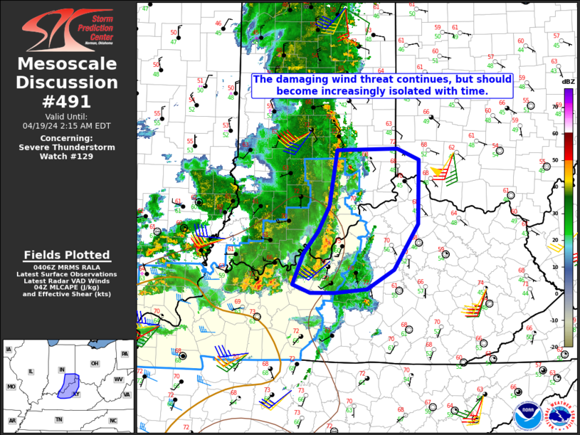
MD 0491 CONCERNING SEVERE THUNDERSTORM WATCH 129… FOR PARTS OF SOUTHEAST IN…NORTHERN KY…FAR SOUTHWEST OH Mesoscale Discussion 0491 NWS Storm Prediction Center Norman OK 1108 PM CDT Thu Apr 18 2024 Areas affected…Parts of southeast IN…northern KY…far southwest OH Concerning…Severe Thunderstorm Watch 129… Valid 190408Z – 190615Z The severe weather threat for Severe Thunderstorm Watch …
Continue reading SPC MD 491
SPC Severe Thunderstorm Watch 126 Status Reports
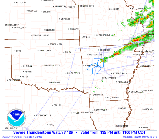
WW 0126 Status Updates STATUS REPORT ON WW 126 SEVERE WEATHER THREAT CONTINUES RIGHT OF A LINE FROM 15 N HOT TO 35 SE FSM TO 40 NW RUE TO 15 SSW FLP. ..DEAN..04/19/24 ATTN…WFO…TSA…LZK…SHV… STATUS REPORT FOR WS 126 SEVERE WEATHER THREAT CONTINUES FOR THE FOLLOWING AREAS ARC071-083-115-149-190440- AR . ARKANSAS COUNTIES INCLUDED ARE …
Continue reading SPC Severe Thunderstorm Watch 126 Status Reports
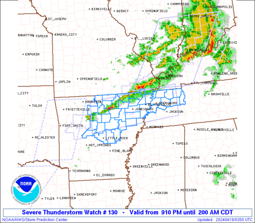
SPC Severe Thunderstorm Watch 130
WW 130 SEVERE TSTM AR MO TN 190210Z – 190700Z URGENT – IMMEDIATE BROADCAST REQUESTED Severe Thunderstorm Watch Number 130 NWS Storm Prediction Center Norman OK 910 PM CDT Thu Apr 18 2024 The NWS Storm Prediction Center has issued a * Severe Thunderstorm Watch for portions of Central and Northern Arkansas Missouri Bootheel Northwest …
Continue reading SPC Severe Thunderstorm Watch 130
SPC Severe Thunderstorm Watch 128 Status Reports
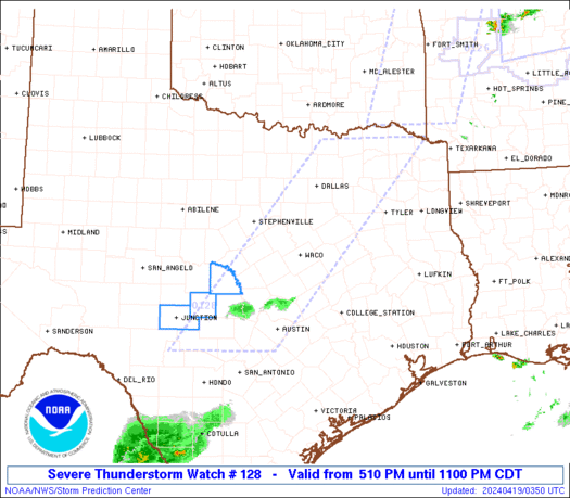
WW 0128 Status Updates STATUS REPORT ON WW 128 SEVERE WEATHER THREAT CONTINUES RIGHT OF A LINE FROM 20 S BWD TO 35 W CLL. ..WEINMAN..04/19/24 ATTN…WFO…FWD…EWX…SJT… STATUS REPORT FOR WS 128 SEVERE WEATHER THREAT CONTINUES FOR THE FOLLOWING AREAS TXC031-053-171-259-265-267-299-319-411-491-190240- TX . TEXAS COUNTIES INCLUDED ARE BLANCO BURNET GILLESPIE KENDALL KERR KIMBLE LLANO MASON …
Continue reading SPC Severe Thunderstorm Watch 128 Status Reports