
WW 0336 Status Updates STATUS REPORT ON WW 336 THE SEVERE WEATHER THREAT CONTINUES ACROSS THE ENTIRE WATCH AREA. ..MOSIER..05/27/24 ATTN…WFO…FWD…EWX…HGX…SHV…SJT… STATUS REPORT FOR WS 336 SEVERE WEATHER THREAT CONTINUES FOR THE FOLLOWING AREAS TXC001-013-019-021-027-029-031-035-041-051-053-055-073-085-091- 093-099-113-121-127-133-137-139-143-145-161-163-171-187-193-209- 213-217-221-225-237-251-257-259-265-267-271-281-287-289-293-299- 309-313-319-323-325-331-333-349-363-367-379-385-395-397-411-423- 425-429-439-453-463-465-467-491-493-497-499-503-507-280040- TX . TEXAS COUNTIES INCLUDED ARE ANDERSON ATASCOSA BANDERA BASTROP BELL BEXAR BLANCO BOSQUE BRAZOS BURLESON …
Continue reading SPC Severe Thunderstorm Watch 336 Status Reports
Month:May 2024
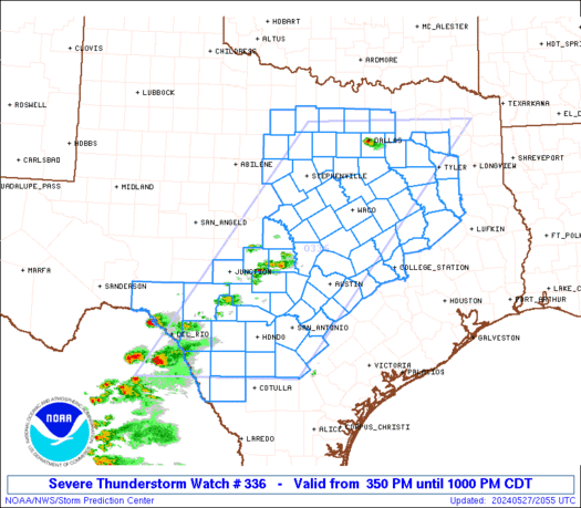
SPC Severe Thunderstorm Watch 336
WW 336 SEVERE TSTM TX 272050Z – 280300Z URGENT – IMMEDIATE BROADCAST REQUESTED Severe Thunderstorm Watch Number 336 NWS Storm Prediction Center Norman OK 350 PM CDT Mon May 27 2024 The NWS Storm Prediction Center has issued a * Severe Thunderstorm Watch for portions of North and Central Texas * Effective this Monday afternoon …
Continue reading SPC Severe Thunderstorm Watch 336
SPC Severe Thunderstorm Watch 337

WW 337 SEVERE TSTM AL FL CW 272210Z – 280300Z URGENT – IMMEDIATE BROADCAST REQUESTED Severe Thunderstorm Watch Number 337 NWS Storm Prediction Center Norman OK 510 PM CDT Mon May 27 2024 The NWS Storm Prediction Center has issued a * Severe Thunderstorm Watch for portions of Southern Alabama Western Florida Panhandle Coastal Waters …
Continue reading SPC Severe Thunderstorm Watch 337
SPC MD 1020

MD 1020 CONCERNING SEVERE THUNDERSTORM WATCH 333… FOR PORTIONS OF NY…PA AND NJ Mesoscale Discussion 1020 NWS Storm Prediction Center Norman OK 0340 PM CDT Mon May 27 2024 Areas affected…portions of NY…PA and NJ Concerning…Severe Thunderstorm Watch 333… Valid 272040Z – 272215Z The severe weather threat for Severe Thunderstorm Watch 333 continues. SUMMARY…Additional bands …
Continue reading SPC MD 1020
SPC MD 1021

MD 1021 CONCERNING TORNADO WATCH 335… FOR PORTIONS OF EASTERN NORTH CAROLINA AND EASTERN VIRGINIA Mesoscale Discussion 1021 NWS Storm Prediction Center Norman OK 0349 PM CDT Mon May 27 2024 Areas affected…portions of eastern North Carolina and eastern Virginia Concerning…Tornado Watch 335… Valid 272049Z – 272215Z The severe weather threat for Tornado Watch 335 …
Continue reading SPC MD 1021
SPC MD 1018

MD 1018 CONCERNING SEVERE POTENTIAL…WATCH LIKELY FOR PORTIONS OF CENTRAL TX Mesoscale Discussion 1018 NWS Storm Prediction Center Norman OK 0248 PM CDT Mon May 27 2024 Areas affected…portions of central TX Concerning…Severe potential…Watch likely Valid 271948Z – 272115Z Probability of Watch Issuance…80 percent SUMMARY…Isolated severe thunderstorms producing large hail and strong gusts will be …
Continue reading SPC MD 1018
SPC MD 1019

MD 1019 CONCERNING SEVERE THUNDERSTORM WATCH 334… FOR PARTS OF SOUTHEASTERN ALABAMA INTO CENTRAL AND SOUTHERN GEORGIA AND SOUTHERN SOUTH CAROLINA Mesoscale Discussion 1019 NWS Storm Prediction Center Norman OK 0311 PM CDT Mon May 27 2024 Areas affected…parts of southeastern Alabama into central and southern Georgia and southern South Carolina Concerning…Severe Thunderstorm Watch 334… …
Continue reading SPC MD 1019
SPC MD 1017

MD 1017 CONCERNING SEVERE POTENTIAL…WATCH LIKELY FOR PORTIONS OF NORTH/CENTRAL TX Mesoscale Discussion 1017 NWS Storm Prediction Center Norman OK 0204 PM CDT Mon May 27 2024 Areas affected…portions of north/central TX Concerning…Severe potential…Watch likely Valid 271904Z – 272130Z Probability of Watch Issuance…80 percent SUMMARY…Isolated thunderstorms are expected to develop by late afternoon. Very large …
Continue reading SPC MD 1017
SPC MD 1016

MD 1016 CONCERNING SEVERE POTENTIAL…WATCH LIKELY FOR PORTIONS OF NORTHERN SOUTH CAROLINA…EASTERN NORTH CAROLINA…SOUTHEASTERN VIRGINIA Mesoscale Discussion 1016 NWS Storm Prediction Center Norman OK 0137 PM CDT Mon May 27 2024 Areas affected…portions of northern South Carolina…eastern North Carolina…southeastern Virginia Concerning…Severe potential…Watch likely Valid 271837Z – 272000Z Probability of Watch Issuance…80 percent SUMMARY…The severe threat …
Continue reading SPC MD 1016
SPC MD 1014

MD 1014 CONCERNING SEVERE POTENTIAL…WATCH LIKELY FOR PORTIONS OF SOUTHEAST ALABAMA INTO CENTRAL AND SOUTHERN GEORGIA…SOUTHERN SOUTH CAROLINA Mesoscale Discussion 1014 NWS Storm Prediction Center Norman OK 1241 PM CDT Mon May 27 2024 Areas affected…portions of southeast Alabama into central and southern Georgia…southern South Carolina Concerning…Severe potential…Watch likely Valid 271741Z – 271915Z Probability of …
Continue reading SPC MD 1014