

MD 0923 CONCERNING SEVERE THUNDERSTORM WATCH 297… FOR EASTERN NEBRASKA AND NORTH-CENTRAL KANSAS…EASTWARD TO WESTERN IOWA AND NORTHWESTERN MISSOURI Mesoscale Discussion 0923 NWS Storm Prediction Center Norman OK 0115 AM CDT Fri May 24 2024 Areas affected…eastern Nebraska and north-central Kansas…eastward to western Iowa and northwestern Missouri Concerning…Severe Thunderstorm Watch 297… Valid 240615Z – 240815Z …
Continue reading SPC MD 923
Month:May 2024
SPC MD 921

MD 0921 CONCERNING SEVERE THUNDERSTORM WATCH 294…297… FOR CENTRAL AND EASTERN NEBRASKA…FAR NORTHERN KANSAS…WESTERN IOWA Mesoscale Discussion 0921 NWS Storm Prediction Center Norman OK 1038 PM CDT Thu May 23 2024 Areas affected…Central and Eastern Nebraska…Far Northern Kansas…Western Iowa Concerning…Severe Thunderstorm Watch 294…297… Valid 240338Z – 240545Z The severe weather threat for Severe Thunderstorm Watch …
Continue reading SPC MD 921
SPC Severe Thunderstorm Watch 298
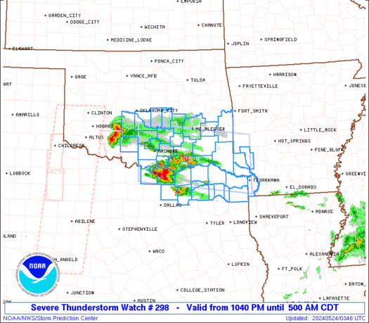
WW 298 SEVERE TSTM AR OK TX 240340Z – 241000Z URGENT – IMMEDIATE BROADCAST REQUESTED Severe Thunderstorm Watch Number 298 NWS Storm Prediction Center Norman OK 1040 PM CDT Thu May 23 2024 The NWS Storm Prediction Center has issued a * Severe Thunderstorm Watch for portions of Extreme southwest Arkansas South central and southeast …
Continue reading SPC Severe Thunderstorm Watch 298
SPC Severe Thunderstorm Watch 294 Status Reports

WW 0294 Status Updates STATUS REPORT ON WW 294 SEVERE WEATHER THREAT CONTINUES RIGHT OF A LINE FROM 20 W MCK TO 20 NNW BUB TO 35 ESE 9V9 TO 40 N HON TO 35 SE JMS. ..MOORE..05/24/24 ATTN…WFO…BIS…FGF…LBF…FSD…ABR…UNR… STATUS REPORT FOR WS 294 SEVERE WEATHER THREAT CONTINUES FOR THE FOLLOWING AREAS NEC015-041-063-071-089-183-240440- NE . …
Continue reading SPC Severe Thunderstorm Watch 294 Status Reports
SPC MD 920

MD 0920 CONCERNING SEVERE POTENTIAL…WATCH POSSIBLE FOR SOUTHEASTERN OKLAHOMA AND NORTH CENTRAL TEXAS NEAR THE RED RIVER Mesoscale Discussion 0920 NWS Storm Prediction Center Norman OK 0935 PM CDT Thu May 23 2024 Areas affected…Southeastern Oklahoma and north central Texas near the Red River Concerning…Severe potential…Watch possible Valid 240235Z – 240400Z Probability of Watch Issuance…40 …
Continue reading SPC MD 920
SPC Tornado Watch 295 Status Reports

WW 0295 Status Updates STATUS REPORT ON WW 295 SEVERE WEATHER THREAT CONTINUES RIGHT OF A LINE FROM 25 SW SPS TO 40 SSW LTS TO 20 SSW CSM TO 15 NNW CHK. ..MOORE..05/24/24 ATTN…WFO…OUN…SJT…LUB…AMA… STATUS REPORT FOR WT 295 SEVERE WEATHER THREAT CONTINUES FOR THE FOLLOWING AREAS OKC031-033-065-075-141-240340- OK . OKLAHOMA COUNTIES INCLUDED ARE …
Continue reading SPC Tornado Watch 295 Status Reports
SPC MD 919

MD 0919 CONCERNING SEVERE THUNDERSTORM WATCH 294… FOR NEBRASKA Mesoscale Discussion 0919 NWS Storm Prediction Center Norman OK 0820 PM CDT Thu May 23 2024 Areas affected…Nebraska Concerning…Severe Thunderstorm Watch 294… Valid 240120Z – 240315Z The severe weather threat for Severe Thunderstorm Watch 294 continues. SUMMARY…A severe threat is expected to continue for several more …
Continue reading SPC MD 919
SPC Severe Thunderstorm Watch 297
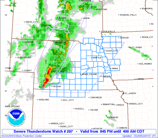
WW 297 SEVERE TSTM IA KS NE SD 240145Z – 240900Z URGENT – IMMEDIATE BROADCAST REQUESTED Severe Thunderstorm Watch Number 297 NWS Storm Prediction Center Norman OK 845 PM CDT Thu May 23 2024 The NWS Storm Prediction Center has issued a * Severe Thunderstorm Watch for portions of Western Iowa Extreme northern Kansas Central …
Continue reading SPC Severe Thunderstorm Watch 297
SPC MD 918

MD 0918 CONCERNING TORNADO WATCH 295… FOR SOUTHWESTERN OKLAHOMA Mesoscale Discussion 0918 NWS Storm Prediction Center Norman OK 0733 PM CDT Thu May 23 2024 Areas affected…Southwestern Oklahoma Concerning…Tornado Watch 295… Valid 240033Z – 240130Z The severe weather threat for Tornado Watch 295 continues. SUMMARY…A dangerous, tornadic supercell is expected to continue slowly moving ESE …
Continue reading SPC MD 918
SPC Tornado Watch 296 Status Reports

WW 0296 Status Updates STATUS REPORT ON WW 296 THE SEVERE WEATHER THREAT CONTINUES ACROSS THE ENTIRE WATCH AREA. ..DEAN..05/24/24 ATTN…WFO…FWD… STATUS REPORT FOR WT 296 SEVERE WEATHER THREAT CONTINUES FOR THE FOLLOWING AREAS TXC001-145-161-289-293-331-395-240140- TX . TEXAS COUNTIES INCLUDED ARE ANDERSON FALLS FREESTONE LEON LIMESTONE MILAM ROBERTSON THE WATCH STATUS MESSAGE IS FOR GUIDANCE …
Continue reading SPC Tornado Watch 296 Status Reports