

MD 0880 CONCERNING TORNADO WATCH 278… FOR PARTS OF WEST CENTRAL ILLINOIS AND NORTHEASTERN MISSOURI SOUTHWESTWARD INTO NORTHEASTERN OKLAHOMA Mesoscale Discussion 0880 NWS Storm Prediction Center Norman OK 0533 PM CDT Tue May 21 2024 Areas affected…parts of west central Illinois and northeastern Missouri southwestward into northeastern Oklahoma Concerning…Tornado Watch 278… Valid 212233Z – 220030Z …
Continue reading SPC MD 880
Month:May 2024
Next Emoji Coming to iOS Could Include Face With Eye Bags, Shovel, Fingerprint, Splatter and More
Apple adds new emoji to the iPhone, iPad, Mac, and other devices regularly based on updates made to the emoji catalog by the Unicode Consortium, and the there are seven new emoji that we could see sometime in late 2024 or early 2025. The next emoji characters being considered include face with bags under eyes, …
Continue reading Next Emoji Coming to iOS Could Include Face With Eye Bags, Shovel, Fingerprint, Splatter and More
SPC MD 878
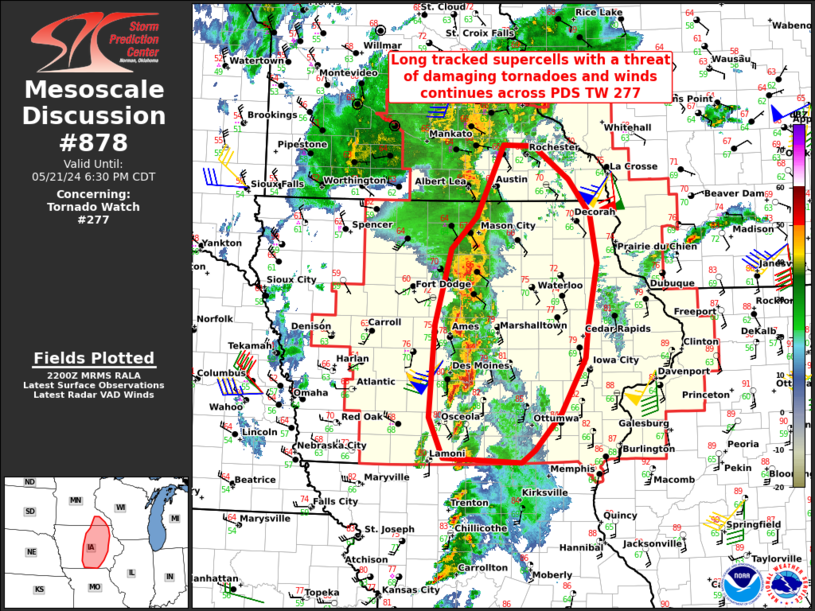
MD 0878 CONCERNING TORNADO WATCH 277… FOR CENTRAL IOWA AND FAR SOUTHEASTERN MINNESOTA Mesoscale Discussion 0878 NWS Storm Prediction Center Norman OK 0503 PM CDT Tue May 21 2024 Areas affected…Central Iowa and far southeastern Minnesota Concerning…Tornado Watch 277… Valid 212203Z – 212330Z The severe weather threat for Tornado Watch 277 continues. SUMMARY…Long tracked supercells …
Continue reading SPC MD 878
SPC MD 879

MD 0879 CONCERNING TORNADO WATCH 277… FOR CENTRAL IOWA INTO NORTHEAST IOWA AND FAR SOUTHWEST WISCONSIN. Mesoscale Discussion 0879 NWS Storm Prediction Center Norman OK 0509 PM CDT Tue May 21 2024 Areas affected…Central Iowa into northeast Iowa and far southwest Wisconsin. Concerning…Tornado Watch 277… Valid 212209Z – 212345Z The severe weather threat for Tornado …
Continue reading SPC MD 879
SPC MD 875

MD 0875 CONCERNING TORNADO WATCH 277… FOR SOUTHWEST/SOUTH-CENTRAL IA Mesoscale Discussion 0875 NWS Storm Prediction Center Norman OK 0320 PM CDT Tue May 21 2024 Areas affected…Southwest/South-Central IA Concerning…Tornado Watch 277… Valid 212020Z – 212145Z The severe weather threat for Tornado Watch 277 continues. SUMMARY…A localized corridor favorable for strong tornadoes exists across southwest/south-central Iowa, …
Continue reading SPC MD 875
SPC MD 876
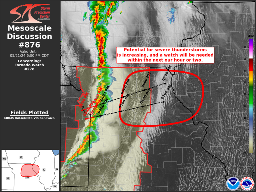
MD 0876 CONCERNING TORNADO WATCH 278… FOR NORTHEAST/NORTH-CENTRAL/CENTRAL MO…WEST-CENTRAL IL Mesoscale Discussion 0876 NWS Storm Prediction Center Norman OK 0354 PM CDT Tue May 21 2024 Areas affected…Northeast/North-Central/Central MO…West-Central IL Concerning…Tornado Watch 278… Valid 212054Z – 212300Z The severe weather threat for Tornado Watch 278 continues. SUMMARY…The potential for severe thunderstorms capable of all severe …
Continue reading SPC MD 876
SPC MD 877
MD 0877 CONCERNING SEVERE POTENTIAL…WATCH POSSIBLE FOR PARTS OF CENTRAL AND NORTHERN ARKANSAS Mesoscale Discussion 0877 NWS Storm Prediction Center Norman OK 0355 PM CDT Tue May 21 2024 Areas affected…Parts of central and northern Arkansas Concerning…Severe potential…Watch possible Valid 212055Z – 212300Z Probability of Watch Issuance…40 percent SUMMARY…Large hail and isolated damaging winds are …
Continue reading SPC MD 877
iOS 18 Apple Music App to Get Smarter Song Transitions
With iOS 18 and macOS 15, the Apple Music app will gain smarter song transitions, reports AppleInsider. Apple is reportedly testing a new feature called “smart song transitions” that would be an improvement to the current crossfade option that comes into play when transitioning from one song to the next. With smart song transitions, Apple …
Continue reading iOS 18 Apple Music App to Get Smarter Song Transitions
New ‘Parkour’ Immersive Video Coming to Vision Pro on Friday
Apple is set to release a new immersive video on the Vision Pro on Friday, with “Parkour” labeled as episode two in the “Adventure” series. Episode one is the “Highlining” video that shows highliner Faith Dickey walking across a tightrope 3,000 feet above Norway’s fjords. A description of the Parkour episode invites Vision Pro wearers …
Continue reading New ‘Parkour’ Immersive Video Coming to Vision Pro on Friday
SPC Tornado Watch 276 Status Reports
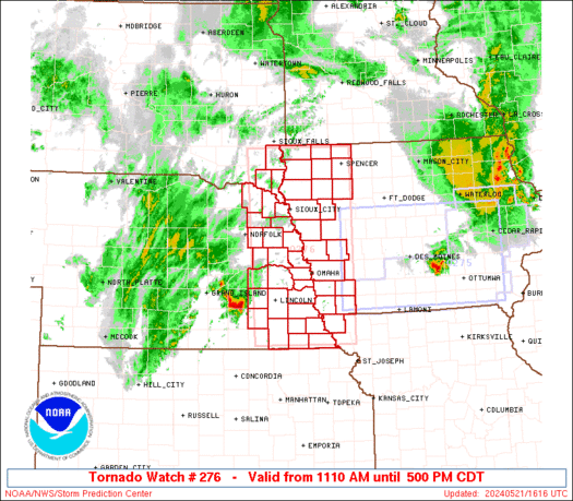
WW 0276 Status Updates STATUS REPORT ON WW 276 SEVERE WEATHER THREAT CONTINUES RIGHT OF A LINE FROM FNB TO 25 SW SLB TO 10 SSE FSD. ..HART..05/21/24 ATTN…WFO…FSD…OAX…EAX… STATUS REPORT FOR WT 276 SEVERE WEATHER THREAT CONTINUES FOR THE FOLLOWING AREAS IAC021-035-041-059-093-119-137-141-143-145-155-165-167-212040- IA . IOWA COUNTIES INCLUDED ARE BUENA VISTA CHEROKEE CLAY DICKINSON IDA …
Continue reading SPC Tornado Watch 276 Status Reports