
WW 0271 Status Updates STATUS REPORT ON WW 271 SEVERE WEATHER THREAT CONTINUES RIGHT OF A LINE FROM 5 WNW EAR TO 15 W OMA. ..KERR..05/21/24 ATTN…WFO…OAX…GID… STATUS REPORT FOR WS 271 SEVERE WEATHER THREAT CONTINUES FOR THE FOLLOWING AREAS IAC085-133-155-165-210540- IA . IOWA COUNTIES INCLUDED ARE HARRISON MONONA POTTAWATTAMIE SHELBY NEC001-019-025-035-055-059-061-067-079-081-083-095-097-099-109- 129-131-137-151-153-155-159-169-181-185-210540- NE . …
Continue reading SPC Severe Thunderstorm Watch 271 Status Reports
Month:May 2024
SPC Severe Thunderstorm Watch 270 Status Reports
WW 0270 Status Updates STATUS REPORT ON WW 270 SEVERE WEATHER THREAT CONTINUES RIGHT OF A LINE FROM 35 W SNY TO 5 ESE TOR. ..KERR..05/21/24 ATTN…WFO…CYS… STATUS REPORT FOR WS 270 SEVERE WEATHER THREAT CONTINUES FOR THE FOLLOWING AREAS NEC007-033-105-123-157-210340- NE . NEBRASKA COUNTIES INCLUDED ARE BANNER CHEYENNE KIMBALL MORRILL SCOTTS BLUFF THE WATCH …
Continue reading SPC Severe Thunderstorm Watch 270 Status Reports
SPC Severe Thunderstorm Watch 272 Status Reports
WW 0272 Status Updates STATUS REPORT ON WW 272 THE SEVERE WEATHER THREAT CONTINUES ACROSS THE ENTIRE WATCH AREA. FOR ADDITIONAL INFORMATION SEE MESOSCALE DISCUSSION 0860 ..BENTLEY..05/21/24 ATTN…WFO…FSD…DMX…ARX…MPX… STATUS REPORT FOR WS 272 SEVERE WEATHER THREAT CONTINUES FOR THE FOLLOWING AREAS IAC021-033-035-041-047-059-063-067-081-089-091-093-109-131-141- 143-147-149-151-161-167-189-193-195-197-210340- IA . IOWA COUNTIES INCLUDED ARE BUENA VISTA CERRO GORDO CHEROKEE CLAY …
Continue reading SPC Severe Thunderstorm Watch 272 Status Reports
SPC Tornado Watch 273

WW 273 TORNADO CO KS NE 210155Z – 210800Z URGENT – IMMEDIATE BROADCAST REQUESTED Tornado Watch Number 273 NWS Storm Prediction Center Norman OK 855 PM CDT Mon May 20 2024 The NWS Storm Prediction Center has issued a * Tornado Watch for portions of Extreme northeast Colorado Extreme northwest Kansas Southwest Nebraska * Effective …
Continue reading SPC Tornado Watch 273
SPC Severe Thunderstorm Watch 268 Status Reports
WW 0268 Status Updates STATUS REPORT ON WW 268 SEVERE WEATHER THREAT CONTINUES RIGHT OF A LINE FROM 25 SSE AZO TO 25 WSW LAN TO 35 WSW MBS TO 30 WNW MBS TO 25 S HTL. WW 268 WILL BE ALLOWED TO EXPIRE AT 210200Z. ..BENTLEY..05/21/24 ATTN…WFO…GRR… STATUS REPORT FOR WS 268 SEVERE WEATHER …
Continue reading SPC Severe Thunderstorm Watch 268 Status Reports
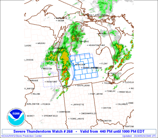
SPC Severe Thunderstorm Watch 268
WW 268 SEVERE TSTM MI LM 202040Z – 210200Z URGENT – IMMEDIATE BROADCAST REQUESTED Severe Thunderstorm Watch Number 268 NWS Storm Prediction Center Norman OK 440 PM EDT Mon May 20 2024 The NWS Storm Prediction Center has issued a * Severe Thunderstorm Watch for portions of Western and Central Lower Michigan Lake Michigan * …
Continue reading SPC Severe Thunderstorm Watch 268
SPC Tornado Watch 269
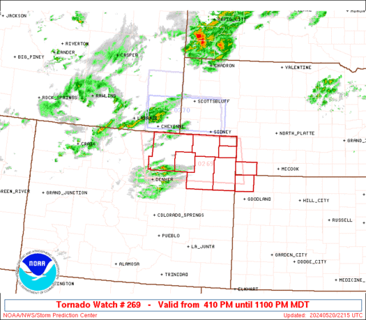
WW 269 TORNADO CO KS NE 202210Z – 210500Z URGENT – IMMEDIATE BROADCAST REQUESTED Tornado Watch Number 269 NWS Storm Prediction Center Norman OK 410 PM MDT Mon May 20 2024 The NWS Storm Prediction Center has issued a * Tornado Watch for portions of Northeast Colorado Extreme northwest Kansas Extreme southwest Nebraska * Effective …
Continue reading SPC Tornado Watch 269
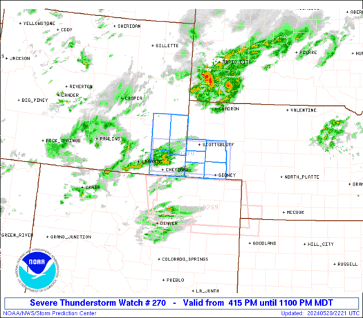
SPC Severe Thunderstorm Watch 270
WW 270 SEVERE TSTM NE WY 202215Z – 210500Z URGENT – IMMEDIATE BROADCAST REQUESTED Severe Thunderstorm Watch Number 270 NWS Storm Prediction Center Norman OK 415 PM MDT Mon May 20 2024 The NWS Storm Prediction Center has issued a * Severe Thunderstorm Watch for portions of Southwest Nebraska Panhandle Southeast Wyoming * Effective this …
Continue reading SPC Severe Thunderstorm Watch 270
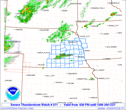
SPC Severe Thunderstorm Watch 271
WW 271 SEVERE TSTM IA NE 202330Z – 210500Z URGENT – IMMEDIATE BROADCAST REQUESTED Severe Thunderstorm Watch Number 271 NWS Storm Prediction Center Norman OK 630 PM CDT Mon May 20 2024 The NWS Storm Prediction Center has issued a * Severe Thunderstorm Watch for portions of Extreme west central Iowa South central into east …
Continue reading SPC Severe Thunderstorm Watch 271
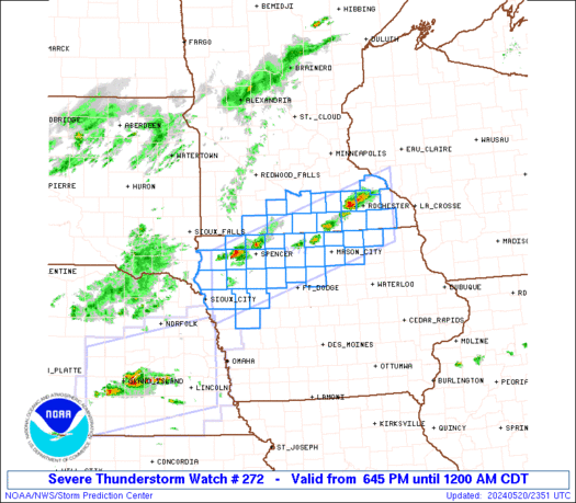
SPC Severe Thunderstorm Watch 272
WW 272 SEVERE TSTM IA MN 202345Z – 210500Z URGENT – IMMEDIATE BROADCAST REQUESTED Severe Thunderstorm Watch Number 272 NWS Storm Prediction Center Norman OK 645 PM CDT Mon May 20 2024 The NWS Storm Prediction Center has issued a * Severe Thunderstorm Watch for portions of Northwest and north central Iowa South central and …
Continue reading SPC Severe Thunderstorm Watch 272