
When introducing the new M4 iPad Pro models, Apple showed a video of a hydraulic press crushing all manner of creative tools, including musical instruments, electronic equipment, arcade games, paint and brushes, computers, cameras, and more, with the aim of demonstrating how the iPad represents all of the tools condensed into a single device. The …
Continue reading Apple Apologizes for ‘Crush’ iPad Pro Ad, Won’t Put It on TV
Month:May 2024
iPad Pro’s M4 Chip Outperforms M3 by Up to 25%
Benchmarks for the new M4 iPad Pro models have popped up on Geekbench, giving us an idea of how much faster Apple’s second-generation 3-nanometer chips are compared to the M3, M2, and other prior-generation Apple silicon chips. The 10-core variant of the M4 chip earned an average single-core score of 3,695 and an average multi-core …
Continue reading iPad Pro’s M4 Chip Outperforms M3 by Up to 25%
13-Inch iPad Air Features 20% Brighter Display Than 11-Inch iPad Air
The new 13-inch iPad Air has a max display brightness of 600 nits, which is 20% higher than the 11-inch iPad Air, according to Apple’s tech specs for the devices. This means the 13-inch iPad Air’s peak brightness is equal to the previous-generation iPad Pro models with the M2 chip for standard dynamic range (SDR) …
Continue reading 13-Inch iPad Air Features 20% Brighter Display Than 11-Inch iPad Air
Every Model of Apple’s M1 iPad Air Drops to Record Low Prices on Amazon
Today we’re tracking multiple record low prices across the M1 iPad Air on Amazon, with $150 off every configuration of these now-discontinued tablets. This comes just a few days after Apple announced the new M2 iPad Air, which start at $599. Note: MacRumors is an affiliate partner with Amazon. When you click a link and …
Continue reading Every Model of Apple’s M1 iPad Air Drops to Record Low Prices on Amazon
SPC Severe Thunderstorm Watch 230 Status Reports
WW 0230 Status Updates STATUS REPORT ON WW 230 SEVERE WEATHER THREAT CONTINUES RIGHT OF A LINE FROM 30 SSW CTY TO 15 SSW GNV TO 30 E GNV TO 20 S JAX TO 15 W SSI TO 30 N SSI TO 35 E SAV. ..JEWELL..05/10/24 ATTN…WFO…JAX…TBW…CHS…FFC… STATUS REPORT FOR WS 230 SEVERE WEATHER THREAT …
Continue reading SPC Severe Thunderstorm Watch 230 Status Reports
SPC MD 746

MD 0746 CONCERNING SEVERE THUNDERSTORM WATCH 229…230… FOR SOUTHEAST GEORGIA…NORTHERN AND CENTRAL FLORIDA Mesoscale Discussion 0746 NWS Storm Prediction Center Norman OK 0717 AM CDT Fri May 10 2024 Areas affected…Southeast Georgia…Northern and Central Florida Concerning…Severe Thunderstorm Watch 229…230… Valid 101217Z – 101445Z The severe weather threat for Severe Thunderstorm Watch 229, 230 continues. SUMMARY…Wind …
Continue reading SPC MD 746
SPC Severe Thunderstorm Watch 229 Status Reports
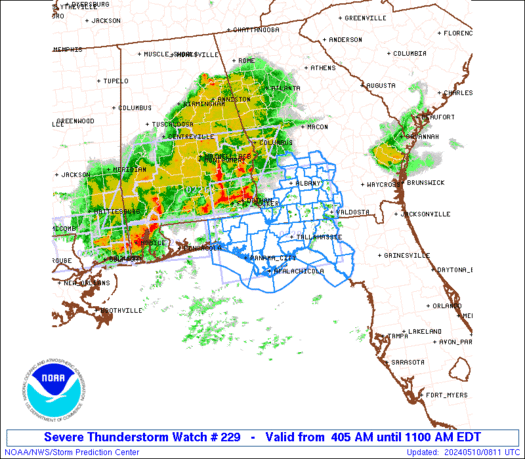
WW 0229 Status Updates STATUS REPORT ON WW 229 SEVERE WEATHER THREAT CONTINUES RIGHT OF A LINE FROM 45 WSW PFN TO 20 E MAI TO 15 E ABY TO 45 NE ABY. ..BROYLES..05/10/24 ATTN…WFO…TAE…FFC… STATUS REPORT FOR WS 229 SEVERE WEATHER THREAT CONTINUES FOR THE FOLLOWING AREAS FLC005-013-029-037-039-045-065-067-073-077-079-123-129-101140- FL . FLORIDA COUNTIES INCLUDED ARE …
Continue reading SPC Severe Thunderstorm Watch 229 Status Reports
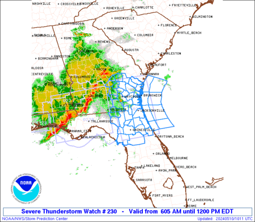
SPC Severe Thunderstorm Watch 230
WW 230 SEVERE TSTM FL GA CW 101005Z – 101600Z URGENT – IMMEDIATE BROADCAST REQUESTED Severe Thunderstorm Watch Number 230 NWS Storm Prediction Center Norman OK 605 AM EDT Fri May 10 2024 The NWS Storm Prediction Center has issued a * Severe Thunderstorm Watch for portions of Northern Florida Southeast Georgia Coastal Waters * …
Continue reading SPC Severe Thunderstorm Watch 230
SPC Severe Thunderstorm Watch 226 Status Reports

WW 0226 Status Updates STATUS REPORT ON WW 226 SEVERE WEATHER THREAT CONTINUES RIGHT OF A LINE FROM 25 SSW DHN TO 30 E DHN TO 15 WNW ABY. ..BROYLES..05/10/24 ATTN…WFO…BMX…MOB…TAE…FFC…JAN… STATUS REPORT FOR WS 226 SEVERE WEATHER THREAT CONTINUES FOR THE FOLLOWING AREAS ALC069-101140- AL . ALABAMA COUNTIES INCLUDED ARE HOUSTON GAC037-099-101140- GA . …
Continue reading SPC Severe Thunderstorm Watch 226 Status Reports
SPC Severe Thunderstorm Watch 227 Status Reports
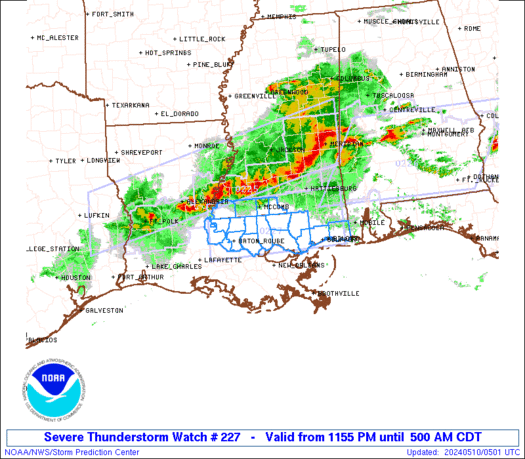
WW 0227 Status Updates STATUS REPORT ON WW 227 SEVERE WEATHER THREAT CONTINUES RIGHT OF A LINE FROM 20 SW GPT TO 40 NNE GPT TO 20 NNW MOB. ..BROYLES..05/10/24 ATTN…WFO…LIX… STATUS REPORT FOR WS 227 SEVERE WEATHER THREAT CONTINUES FOR THE FOLLOWING AREAS MSC047-059-100940- MS . MISSISSIPPI COUNTIES INCLUDED ARE HARRISON JACKSON THE WATCH …
Continue reading SPC Severe Thunderstorm Watch 227 Status Reports