
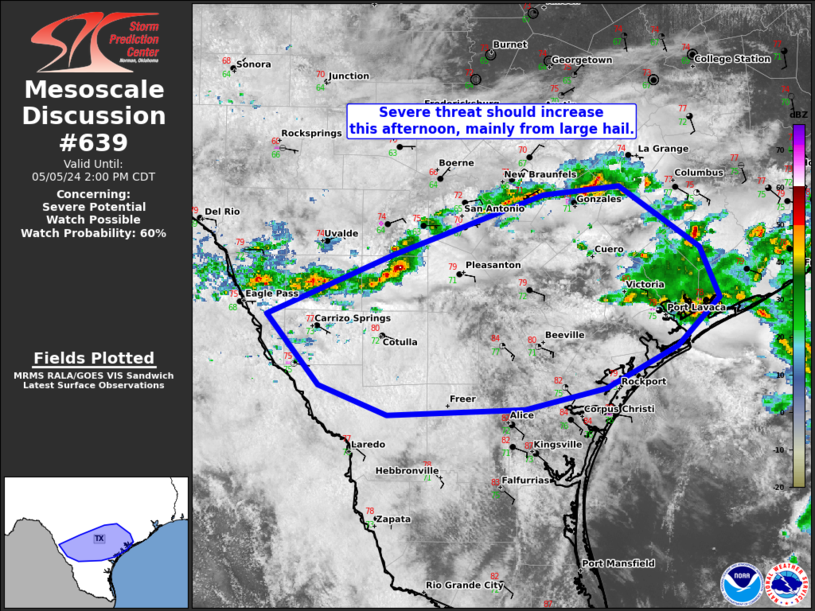
MD 0639 CONCERNING SEVERE POTENTIAL…WATCH POSSIBLE FOR SOUTH-CENTRAL TX Mesoscale Discussion 0639 NWS Storm Prediction Center Norman OK 1202 PM CDT Sun May 05 2024 Areas affected…South-central TX Concerning…Severe potential…Watch possible Valid 051702Z – 051900Z Probability of Watch Issuance…60 percent SUMMARY…Ongoing convection should intensify across parts of south-central Texas at some point this afternoon. Primary …
Continue reading SPC MD 639
Month:May 2024
SPC Severe Thunderstorm Watch 185 Status Reports
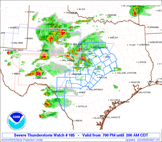
WW 0185 Status Updates STATUS REPORT ON WW 185 SEVERE WEATHER THREAT CONTINUES RIGHT OF A LINE FROM 35 WSW JCT TO 45 NE JCT TO 40 SSE BWD TO 40 W ACT TO 20 NW ACT TO 20 SSW DAL. ..BROYLES..05/05/24 ATTN…WFO…EWX…FWD…SJT… STATUS REPORT FOR WS 185 SEVERE WEATHER THREAT CONTINUES FOR THE FOLLOWING …
Continue reading SPC Severe Thunderstorm Watch 185 Status Reports
SPC MD 638
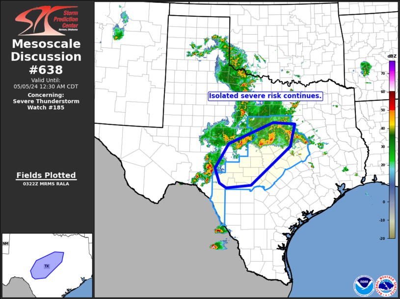
MD 0638 CONCERNING SEVERE THUNDERSTORM WATCH 185… FOR PORTIONS OF CENTRAL TEXAS Mesoscale Discussion 0638 NWS Storm Prediction Center Norman OK 1025 PM CDT Sat May 04 2024 Areas affected…portions of central Texas Concerning…Severe Thunderstorm Watch 185… Valid 050325Z – 050530Z The severe weather threat for Severe Thunderstorm Watch 185 continues. SUMMARY…Widespread convection continues across …
Continue reading SPC MD 638
SPC Tornado Watch 184 Status Reports
WW 0184 Status Updates STATUS REPORT ON WW 184 SEVERE WEATHER THREAT CONTINUES RIGHT OF A LINE FROM 20 SSE 6R6 TO 40 ENE 6R6 TO 50 WSW SJT TO 25 SSE BGS. ..FLOURNOY..05/05/24 ATTN…WFO…MAF…SJT…EWX… STATUS REPORT FOR WT 184 SEVERE WEATHER THREAT CONTINUES FOR THE FOLLOWING AREAS TXC095-105-235-307-327-383-413-435-451-465-050340- TX . TEXAS COUNTIES INCLUDED ARE …
Continue reading SPC Tornado Watch 184 Status Reports
SPC Severe Thunderstorm Watch 183 Status Reports
WW 0183 Status Updates STATUS REPORT ON WW 183 SEVERE WEATHER THREAT CONTINUES RIGHT OF A LINE FROM 45 SSE MAF TO 40 ESE BGS TO 35 NW ABI TO 55 NNW ABI TO 60 E LBB. ..FLOURNOY..05/05/24 ATTN…WFO…MAF…SJT…LUB… STATUS REPORT FOR WS 183 SEVERE WEATHER THREAT CONTINUES FOR THE FOLLOWING AREAS TXC049-059-081-083-207-253-353-399-417-441-447-050340- TX . …
Continue reading SPC Severe Thunderstorm Watch 183 Status Reports
SPC MD 636

MD 0636 CONCERNING SEVERE THUNDERSTORM WATCH 183… FOR SOUTH PLAINS REGION TO CENTRAL NORTH TEXAS Mesoscale Discussion 0636 NWS Storm Prediction Center Norman OK 0733 PM CDT Sat May 04 2024 Areas affected…South Plains region to central North Texas Concerning…Severe Thunderstorm Watch 183… Valid 050033Z – 050230Z The severe weather threat for Severe Thunderstorm Watch …
Continue reading SPC MD 636
SPC MD 634

MD 0634 CONCERNING TORNADO WATCH 184… FOR PARTS OF WESTERN AND CENTRAL TEXAS Mesoscale Discussion 0634 NWS Storm Prediction Center Norman OK 0631 PM CDT Sat May 04 2024 Areas affected…parts of western and central Texas Concerning…Tornado Watch 184… Valid 042331Z – 050130Z The severe weather threat for Tornado Watch 184 continues. SUMMARY…Isolated supercells, posing …
Continue reading SPC MD 634
SPC MD 635

MD 0635 CONCERNING SEVERE POTENTIAL…WATCH UNLIKELY FOR THE ARKLATEX REGION Mesoscale Discussion 0635 NWS Storm Prediction Center Norman OK 0703 PM CDT Sat May 04 2024 Areas affected…the ArkLaTex region Concerning…Severe potential…Watch unlikely Valid 050003Z – 050100Z Probability of Watch Issuance…5 percent SUMMARY…Isolated wind gusts and small hail are possible through the evening hours in …
Continue reading SPC MD 635
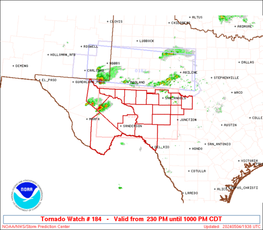
SPC Tornado Watch 184
WW 184 TORNADO TX 041930Z – 050300Z URGENT – IMMEDIATE BROADCAST REQUESTED Tornado Watch Number 184 NWS Storm Prediction Center Norman OK 230 PM CDT Sat May 4 2024 The NWS Storm Prediction Center has issued a * Tornado Watch for portions of Southwest Texas * Effective this Saturday afternoon and evening from 230 PM …
Continue reading SPC Tornado Watch 184
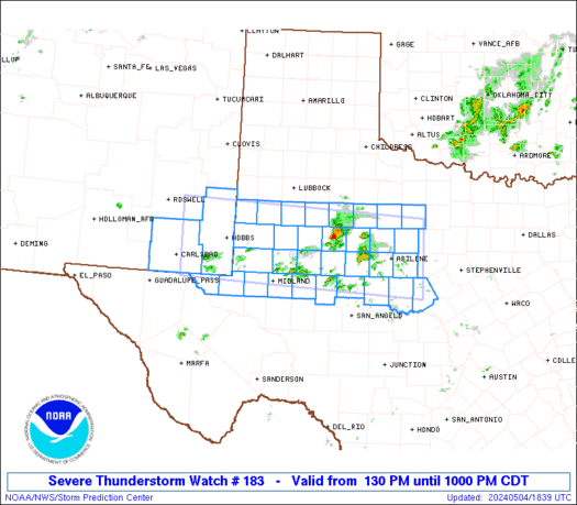
SPC Severe Thunderstorm Watch 183
WW 183 SEVERE TSTM NM TX 041830Z – 050300Z URGENT – IMMEDIATE BROADCAST REQUESTED Severe Thunderstorm Watch Number 183 NWS Storm Prediction Center Norman OK 130 PM CDT Sat May 4 2024 The NWS Storm Prediction Center has issued a * Severe Thunderstorm Watch for portions of Southeast New Mexico West into Northwest Texas * …
Continue reading SPC Severe Thunderstorm Watch 183