
WW 0437 Status Updates STATUS REPORT ON WW 437 SEVERE WEATHER THREAT CONTINUES RIGHT OF A LINE FROM 50 NW LRD TO 25 WNW ALI TO 55 ESE CRP. ..LEITMAN..06/20/24 ATTN…WFO…CRP…EWX…BRO…HGX… STATUS REPORT FOR WT 437 SEVERE WEATHER THREAT CONTINUES FOR THE FOLLOWING AREAS TXC047-061-131-215-247-249-261-273-355-427-479-489-505-201040- TX . TEXAS COUNTIES INCLUDED ARE BROOKS CAMERON DUVAL HIDALGO …
Continue reading SPC Tornado Watch 437 Status Reports
Month:June 2024
Apple Education Store Down in US and Canada, Back to School Offer Expected Soon
Apple’s online education store has gone down in the United States and Canada, as Apple prepares to launch its annual Back to School promotion for university students. Apple’s back to school sales provide students with a free Apple gift card when purchasing a Mac or an iPad, and this year’s promotion could help Apple push …
Continue reading Apple Education Store Down in US and Canada, Back to School Offer Expected Soon
SPC MD 1338

MD 1338 CONCERNING TORNADO WATCH 437… FOR DEEP SOUTH TEXAS Mesoscale Discussion 1338 NWS Storm Prediction Center Norman OK 1144 PM CDT Wed Jun 19 2024 Areas affected…Deep South Texas Concerning…Tornado Watch 437… Valid 200444Z – 200645Z The severe weather threat for Tornado Watch 437 continues. SUMMARY…Occasionally strengthening showers and thunderstorms may continue to be …
Continue reading SPC MD 1338
SPC Severe Thunderstorm Watch 436 Status Reports

WW 0436 Status Updates STATUS REPORT ON WW 436 SEVERE WEATHER THREAT CONTINUES RIGHT OF A LINE FROM 15 S ALM TO 45 SSW ROW. REMAING VALID PORTION OF WW 436 MAY BE ALLOWED TO EXPIRE AT 20/03Z. ..EDWARDS..06/20/24 ATTN…WFO…ABQ…EPZ… STATUS REPORT FOR WS 436 SEVERE WEATHER THREAT CONTINUES FOR THE FOLLOWING AREAS NMC019-035-047-200300- NM …
Continue reading SPC Severe Thunderstorm Watch 436 Status Reports
SPC MD 1337

MD 1337 CONCERNING SEVERE THUNDERSTORM WATCH 436… FOR SOUTHERN NEW MEXICO INTO FAR WESTERN TEXAS Mesoscale Discussion 1337 NWS Storm Prediction Center Norman OK 0744 PM CDT Wed Jun 19 2024 Areas affected…southern New Mexico into far western Texas Concerning…Severe Thunderstorm Watch 436… Valid 200044Z – 200145Z The severe weather threat for Severe Thunderstorm Watch …
Continue reading SPC MD 1337
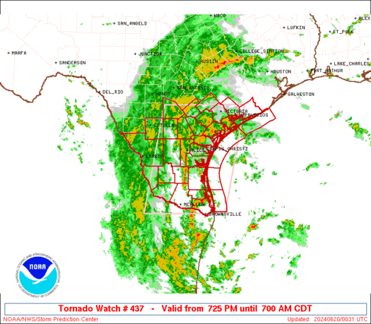
SPC Tornado Watch 437
WW 437 TORNADO TX CW 200025Z – 201200Z URGENT – IMMEDIATE BROADCAST REQUESTED Tornado Watch Number 437 NWS Storm Prediction Center Norman OK 725 PM CDT Wed Jun 19 2024 The NWS Storm Prediction Center has issued a * Tornado Watch for portions of South Texas Coastal Waters * Effective this Wednesday night and Thursday …
Continue reading SPC Tornado Watch 437
SPC MD 1336

MD 1336 CONCERNING SEVERE POTENTIAL…WATCH LIKELY FOR LOWER/MIDDLE TEXAS COAST AND DEEP SOUTH TEXAS Mesoscale Discussion 1336 NWS Storm Prediction Center Norman OK 0657 PM CDT Wed Jun 19 2024 Areas affected…Lower/middle Texas Coast and deep south Texas Concerning…Severe potential…Watch likely Valid 192357Z – 200100Z Probability of Watch Issuance…80 percent SUMMARY…Tornado risk to increase through …
Continue reading SPC MD 1336
SPC Severe Thunderstorm Watch 436
WW 436 SEVERE TSTM NM TX 192055Z – 200300Z URGENT – IMMEDIATE BROADCAST REQUESTED Severe Thunderstorm Watch Number 436 NWS Storm Prediction Center Norman OK 255 PM MDT Wed Jun 19 2024 The NWS Storm Prediction Center has issued a * Severe Thunderstorm Watch for portions of North-Central and South-Central New Mexico Far West Texas …
Continue reading SPC Severe Thunderstorm Watch 436
SPC MD 1335

MD 1335 CONCERNING SEVERE POTENTIAL…WATCH UNLIKELY FOR PORTIONS OF THE MIDDLE TO UPPER MISSISSIPPI VALLEY Mesoscale Discussion 1335 NWS Storm Prediction Center Norman OK 0358 PM CDT Wed Jun 19 2024 Areas affected…portions of the middle to upper Mississippi Valley Concerning…Severe potential…Watch unlikely Valid 192058Z – 192230Z Probability of Watch Issuance…5 percent SUMMARY…Scattered storms may …
Continue reading SPC MD 1335
SPC MD 1334

MD 1334 CONCERNING SEVERE POTENTIAL…WATCH UNLIKELY FOR EAST-CENTRAL NM Mesoscale Discussion 1334 NWS Storm Prediction Center Norman OK 0242 PM CDT Wed Jun 19 2024 Areas affected…east-central NM Concerning…Severe potential…Watch unlikely Valid 191942Z – 192145Z Probability of Watch Issuance…20 percent SUMMARY…A few drifting cells may congeal into a slow-moving cluster, centered on east-central New Mexico, …
Continue reading SPC MD 1334