

MD 1297 CONCERNING SEVERE POTENTIAL…WATCH LIKELY FOR SOUTHERN MN INTO NORTHERN IA AND WEST-CENTRAL WI Mesoscale Discussion 1297 NWS Storm Prediction Center Norman OK 0255 AM CDT Mon Jun 17 2024 Areas affected…southern MN into northern IA and west-central WI Concerning…Severe potential…Watch likely Valid 170755Z – 170930Z Probability of Watch Issuance…80 percent SUMMARY…Isolated large hail …
Continue reading SPC MD 1297
Month:June 2024
SPC Severe Thunderstorm Watch 427

WW 427 SEVERE TSTM IA MN NE SD WI 170810Z – 171500Z URGENT – IMMEDIATE BROADCAST REQUESTED Severe Thunderstorm Watch Number 427 NWS Storm Prediction Center Norman OK 310 AM CDT Mon Jun 17 2024 The NWS Storm Prediction Center has issued a * Severe Thunderstorm Watch for portions of Northern Iowa Southern Minnesota Far …
Continue reading SPC Severe Thunderstorm Watch 427
SPC MD 1296

MD 1296 CONCERNING SEVERE THUNDERSTORM WATCH 426… FOR WESTERN/NORTHERN NE…SOUTH-CENTRAL/SOUTHEAST SD…SOUTHWEST MN…EXTREME NORTHWEST IA Mesoscale Discussion 1296 NWS Storm Prediction Center Norman OK 1134 PM CDT Sun Jun 16 2024 Areas affected…Western/northern NE…south-central/southeast SD…southwest MN…extreme northwest IA Concerning…Severe Thunderstorm Watch 426… Valid 170434Z – 170600Z The severe weather threat for Severe Thunderstorm Watch 426 continues. …
Continue reading SPC MD 1296
SPC Severe Thunderstorm Watch 425 Status Reports
WW 0425 Status Updates STATUS REPORT ON WW 425 SEVERE WEATHER THREAT CONTINUES RIGHT OF A LINE FROM 25 SW SUX TO 20 ESE IML. FOR ADDITIONAL INFORMATION SEE MESOSCALE DISCUSSION 1295 ..DEAN..06/17/24 ATTN…WFO…OAX…GID…LBF…GLD… STATUS REPORT FOR WS 425 SEVERE WEATHER THREAT CONTINUES FOR THE FOLLOWING AREAS NEC027-107-170540- NE . NEBRASKA COUNTIES INCLUDED ARE CEDAR …
Continue reading SPC Severe Thunderstorm Watch 425 Status Reports
SPC MD 1295

MD 1295 CONCERNING SEVERE THUNDERSTORM WATCH 425… FOR SOUTHWEST/CENTRAL/NORTHEAST NE Mesoscale Discussion 1295 NWS Storm Prediction Center Norman OK 1042 PM CDT Sun Jun 16 2024 Areas affected…Southwest/central/northeast NE Concerning…Severe Thunderstorm Watch 425… Valid 170342Z – 170515Z The severe weather threat for Severe Thunderstorm Watch 425 continues. SUMMARY…An isolated severe storm or two cannot be …
Continue reading SPC MD 1295
SPC MD 1294

MD 1294 CONCERNING SEVERE POTENTIAL…WATCH UNLIKELY FOR SOUTH-CENTRAL MICHIGAN INTO FAR NORTHERN INDIANA AND OHIO Mesoscale Discussion 1294 NWS Storm Prediction Center Norman OK 1008 PM CDT Sun Jun 16 2024 Areas affected…south-central Michigan into far northern Indiana and Ohio Concerning…Severe potential…Watch unlikely Valid 170308Z – 170415Z Probability of Watch Issuance…20 percent SUMMARY…A line of …
Continue reading SPC MD 1294
SPC Severe Thunderstorm Watch 426

WW 426 SEVERE TSTM NE SD 170305Z – 171100Z URGENT – IMMEDIATE BROADCAST REQUESTED Severe Thunderstorm Watch Number 426 NWS Storm Prediction Center Norman OK 1005 PM CDT Sun Jun 16 2024 The NWS Storm Prediction Center has issued a * Severe Thunderstorm Watch for portions of Western and Northern Nebraska Southern and Southeastern South …
Continue reading SPC Severe Thunderstorm Watch 426
SPC MD 1293

MD 1293 CONCERNING SEVERE POTENTIAL…WATCH POSSIBLE FOR NORTHEAST CO…SOUTHEAST WY…NE PANHANDLE INTO NORTHWEST NE…SOUTHWEST/SOUTH-CENTRAL SD Mesoscale Discussion 1293 NWS Storm Prediction Center Norman OK 0838 PM CDT Sun Jun 16 2024 Areas affected…Northeast CO…southeast WY…NE Panhandle into northwest NE…southwest/south-central SD Concerning…Severe potential…Watch possible Valid 170138Z – 170345Z Probability of Watch Issuance…40 percent SUMMARY…Strong to potentially …
Continue reading SPC MD 1293
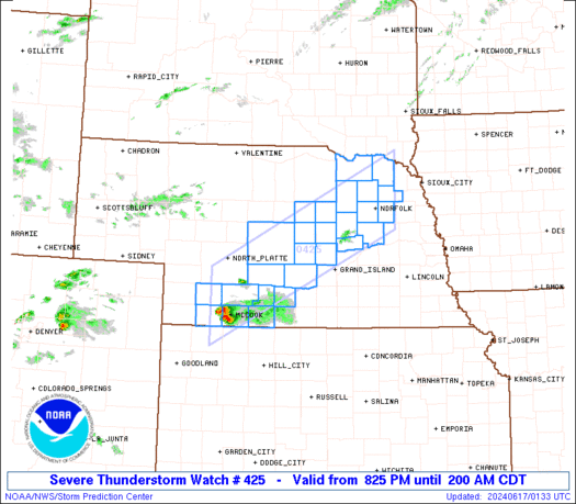
SPC Severe Thunderstorm Watch 425
WW 425 SEVERE TSTM NE 170125Z – 170700Z URGENT – IMMEDIATE BROADCAST REQUESTED Severe Thunderstorm Watch Number 425 NWS Storm Prediction Center Norman OK 825 PM CDT Sun Jun 16 2024 The NWS Storm Prediction Center has issued a * Severe Thunderstorm Watch for portions of Southwest into Central and Northeast Nebraska * Effective this …
Continue reading SPC Severe Thunderstorm Watch 425
SPC MD 1292

MD 1292 CONCERNING SEVERE POTENTIAL…WATCH POSSIBLE FOR SOUTHWEST/CENTRAL NE INTO NORTHEAST CO AND NORTHWEST KS Mesoscale Discussion 1292 NWS Storm Prediction Center Norman OK 0622 PM CDT Sun Jun 16 2024 Areas affected…Southwest/central NE into northeast CO and northwest KS Concerning…Severe potential…Watch possible Valid 162322Z – 170045Z Probability of Watch Issuance…40 percent SUMMARY…Strong to severe …
Continue reading SPC MD 1292