
Apple’s latest iPhones include several headline camera features that are worth using, such as Portrait Mode and Photographic Styles. But if all you want to use is the standard photo mode, there are still several tools and settings that can improve the composition of your pictures and help you capture the perfect shot using more …
Continue reading 6 iPhone Camera Tips to Enhance Your Photography Skills
Month:December 2024
SPC MD 2289
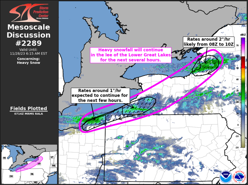
MD 2289 CONCERNING SEVERE POTENTIAL…WATCH UNLIKELY FOR SOUTHWEST MS VICINITY Mesoscale Discussion 2289 NWS Storm Prediction Center Norman OK 0105 AM CST Fri Dec 27 2024 Areas affected…southwest MS vicinity Concerning…Severe potential…Watch unlikely Valid 270705Z – 270800Z Probability of Watch Issuance…20 percent SUMMARY…Potential for a tornado or two may linger in the southwest Mississippi vicinity …
Continue reading SPC MD 2289
SPC Tornado Watch 716 Status Reports

WW 0716 Status Updates STATUS REPORT ON WW 716 SEVERE WEATHER THREAT CONTINUES RIGHT OF A LINE FROM 25 S LCH TO 35 NW LFT. WW 716 IS SCHEDULED TO EXPIRE AT 270800Z. ..GRAMS..12/27/24 ATTN…WFO…LCH…SHV… STATUS REPORT FOR WT 716 SEVERE WEATHER THREAT CONTINUES FOR THE FOLLOWING AREAS LAC001-023-053-270800- LA . LOUISIANA PARISHES INCLUDED ARE …
Continue reading SPC Tornado Watch 716 Status Reports
SPC Tornado Watch 715 Status Reports

WW 0715 Status Updates STATUS REPORT ON WW 715 SEVERE WEATHER THREAT CONTINUES RIGHT OF A LINE FROM 25 NNW LBX TO 25 NNW BPT TO 50 ENE LFK TO 25 N IER. ..THORNTON..12/27/24 ATTN…WFO…SHV…FWD…HGX…LCH… STATUS REPORT FOR WT 715 SEVERE WEATHER THREAT CONTINUES FOR THE FOLLOWING AREAS TXC039-071-167-270140- TX . TEXAS COUNTIES INCLUDED ARE …
Continue reading SPC Tornado Watch 715 Status Reports
SPC Tornado Watch 716
WW 716 TORNADO LA TX CW 270010Z – 270800Z URGENT – IMMEDIATE BROADCAST REQUESTED Tornado Watch Number 716 NWS Storm Prediction Center Norman OK 610 PM CST Thu Dec 26 2024 The NWS Storm Prediction Center has issued a * Tornado Watch for portions of Western and Central Louisiana Far Southeast Texas Coastal Waters * …
Continue reading SPC Tornado Watch 716
SPC Severe Thunderstorm Watch 714 Status Reports

WW 0714 Status Updates Read more Read More
SPC Severe Thunderstorm Watch 714
WW 714 SEVERE TSTM AR LA TX 261720Z – 270100Z URGENT – IMMEDIATE BROADCAST REQUESTED Severe Thunderstorm Watch Number 714 NWS Storm Prediction Center Norman OK 1120 AM CST Thu Dec 26 2024 The NWS Storm Prediction Center has issued a * Severe Thunderstorm Watch for portions of Extreme southwest Arkansas Extreme northwest Louisiana Northeast …
Continue reading SPC Severe Thunderstorm Watch 714
SPC Tornado Watch 715
WW 715 TORNADO LA TX CW 261735Z – 270100Z URGENT – IMMEDIATE BROADCAST REQUESTED Tornado Watch Number 715 NWS Storm Prediction Center Norman OK 1135 AM CST Thu Dec 26 2024 The NWS Storm Prediction Center has issued a * Tornado Watch for portions of Extreme west central Louisiana East central and southeast Texas Coastal …
Continue reading SPC Tornado Watch 715
ChatGPT Experiencing Outage
OpenAI’s popular ChatGPT service is experiencing an outage at the current time, according to the company’s website. A system status page says that there are high error rates for ChatGPT, APIs, and Sora. According to OpenAI, the problem has been ongoing since 11:00 a.m. Pacific Time, and it is the result of an “issue caused …
Continue reading ChatGPT Experiencing Outage
Apple Announces Japanese New Year Promotion With Exclusive AirTag
Apple today announced the upcoming launch of its annual New Year promotion in Japan, providing customers with a free Apple gift card worth up to ¥30,000 with the purchase of eligible Apple devices. Customers in Japan can get an Apple gift card when shopping at Apple from January 2 to January 5, and as a …
Continue reading Apple Announces Japanese New Year Promotion With Exclusive AirTag