
WW 439 SEVERE TSTM CO NE SD WY 201920Z – 210100Z
URGENT – IMMEDIATE BROADCAST REQUESTED
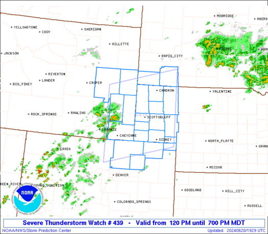
Severe Thunderstorm Watch Number 439
NWS Storm Prediction Center Norman OK
120 PM MDT Thu Jun 20 2024
The NWS Storm Prediction Center has issued a
* Severe Thunderstorm Watch for portions of
Northeast Colorado
Nebraska Panhandle
Southwest South Dakota
Southeast Wyoming
* Effective this Thursday afternoon and evening from 120 PM until
700 PM MDT.
* Primary threats include…
Scattered damaging winds and isolated significant gusts to 75
mph possible
Scattered large hail and isolated very large hail events to 2.5
inches in diameter possible
A tornado or two possible
SUMMARY…Thunderstorms will intensify this afternoon over southeast
Wyoming and northeast Colorado and spread eastward through the early
evening. Supercells capable of very large hail and damaging wind
gusts are the main concern. An isolated tornado and/or landspout or
two is also possible.
The severe thunderstorm watch area is approximately along and 95
statute miles north and south of a line from 40 miles northwest of
Cheyenne WY to 35 miles east northeast of Alliance NE. For a
complete depiction of the watch see the associated watch outline
update (WOUS64 KWNS WOU9).
PRECAUTIONARY/PREPAREDNESS ACTIONS…
REMEMBER…A Severe Thunderstorm Watch means conditions are
favorable for severe thunderstorms in and close to the watch area.
Persons in these areas should be on the lookout for threatening
weather conditions and listen for later statements and possible
warnings. Severe thunderstorms can and occasionally do produce
tornadoes.
&&
OTHER WATCH INFORMATION…CONTINUE…WW 438…
AVIATION…A few severe thunderstorms with hail surface and aloft to
2.5 inches. Extreme turbulence and surface wind gusts to 65 knots. A
few cumulonimbi with maximum tops to 500. Mean storm motion vector
27030.
…Hart