
WW 438 SEVERE TSTM MA ME NH NY VT CW 201700Z – 210000Z
URGENT – IMMEDIATE BROADCAST REQUESTED
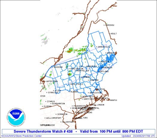
Severe Thunderstorm Watch Number 438
NWS Storm Prediction Center Norman OK
100 PM EDT Thu Jun 20 2024
The NWS Storm Prediction Center has issued a
* Severe Thunderstorm Watch for portions of
Northern Massachusetts
Central and Western Maine
New Hampshire
Northeast New York
Vermont
Coastal Waters
* Effective this Thursday afternoon and evening from 100 PM until
800 PM EDT.
* Primary threats include…
Scattered damaging wind gusts to 70 mph possible
Isolated large hail events to 1 inch in diameter possible
SUMMARY…Scattered thunderstorms will develop through the afternoon
and spread eastward across the watch area. The strongest cells will
pose a risk of locally damaging wind gusts and hail.
The severe thunderstorm watch area is approximately along and 60
statute miles north and south of a line from 40 miles west southwest
of Saranac Lake NY to 25 miles southeast of Bangor ME. For a
complete depiction of the watch see the associated watch outline
update (WOUS64 KWNS WOU8).
PRECAUTIONARY/PREPAREDNESS ACTIONS…
REMEMBER…A Severe Thunderstorm Watch means conditions are
favorable for severe thunderstorms in and close to the watch area.
Persons in these areas should be on the lookout for threatening
weather conditions and listen for later statements and possible
warnings. Severe thunderstorms can and occasionally do produce
tornadoes.
&&
AVIATION…A few severe thunderstorms with hail surface and aloft to
1 inch. Extreme turbulence and surface wind gusts to 60 knots. A few
cumulonimbi with maximum tops to 500. Mean storm motion vector
28030.
…Hart