
WW 466 SEVERE TSTM AL AR LA MS 261950Z – 270200Z
URGENT – IMMEDIATE BROADCAST REQUESTED
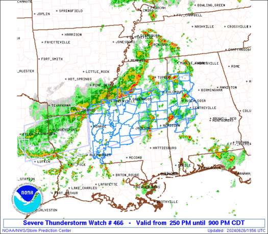
Severe Thunderstorm Watch Number 466
NWS Storm Prediction Center Norman OK
250 PM CDT Wed Jun 26 2024
The NWS Storm Prediction Center has issued a
* Severe Thunderstorm Watch for portions of
West Central Alabama
Southeast Arkansas
Northeast Louisiana
Central Mississippi
* Effective this Wednesday afternoon and evening from 250 PM
until 900 PM CDT.
* Primary threats include…
Scattered damaging wind gusts to 70 mph possible
Isolated large hail events to 1 inch in diameter possible
SUMMARY…A line of thunderstorms over southeast Arkansas will sag
southward into the watch area this afternoon, while other more
isolated cells affect western Alabama. Hot and humid conditions
will promote a risk of locally intense wind gusts with the stronger
cells.
The severe thunderstorm watch area is approximately along and 60
statute miles north and south of a line from 15 miles south
southwest of Monroe LA to 30 miles east northeast of Tuscaloosa AL.
For a complete depiction of the watch see the associated watch
outline update (WOUS64 KWNS WOU6).
PRECAUTIONARY/PREPAREDNESS ACTIONS…
REMEMBER…A Severe Thunderstorm Watch means conditions are
favorable for severe thunderstorms in and close to the watch area.
Persons in these areas should be on the lookout for threatening
weather conditions and listen for later statements and possible
warnings. Severe thunderstorms can and occasionally do produce
tornadoes.
&&
OTHER WATCH INFORMATION…CONTINUE…WW 464…WW 465…
AVIATION…A few severe thunderstorms with hail surface and aloft to
1 inch. Extreme turbulence and surface wind gusts to 60 knots. A few
cumulonimbi with maximum tops to 500. Mean storm motion vector
26035.
…Hart