
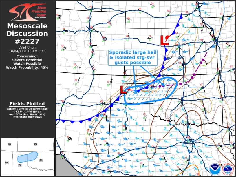
MD 2227 CONCERNING TORNADO WATCH 639…640… FOR NORTHEAST LA INTO CENTRAL/SOUTHERN MS Mesoscale Discussion 2227 NWS Storm Prediction Center Norman OK 0128 AM CST Tue Nov 25 2025 Areas affected…Northeast LA into central/southern MS Concerning…Tornado Watch 639…640… Valid 250728Z – 250900Z The severe weather threat for Tornado Watch 639, 640 continues. SUMMARY…Some tornado and wind-damage …
Continue reading SPC MD 2227
Category:Weather
SPC Tornado Watch 639 Status Reports

WW 0639 Status Updates STATUS REPORT ON WW 639 SEVERE WEATHER THREAT CONTINUES RIGHT OF A LINE FROM 30 ENE GLS TO 45 SSE LFK TO 30 NW POE TO 20 ESE IER TO 40 N ESF. ..DEAN..11/25/25 ATTN…WFO…LCH…SHV…HGX… STATUS REPORT FOR WT 639 SEVERE WEATHER THREAT CONTINUES FOR THE FOLLOWING AREAS LAC003-009-011-039-059-069-079-115-250740- LA . …
Continue reading SPC Tornado Watch 639 Status Reports
SPC MD 2226

MD 2226 CONCERNING TORNADO WATCH 639… FOR NORTHERN/CENTRAL LOUISIANA AND WESTERN MISSISSIPPI Mesoscale Discussion 2226 NWS Storm Prediction Center Norman OK 0922 PM CST Mon Nov 24 2025 Areas affected…Northern/Central Louisiana and western Mississippi Concerning…Tornado Watch 639… Valid 250322Z – 250515Z The severe weather threat for Tornado Watch 639 continues. SUMMARY…Severe threat is expected to …
Continue reading SPC MD 2226
SPC Tornado Watch 640

WW 640 TORNADO LA MS 250440Z – 251200Z URGENT – IMMEDIATE BROADCAST REQUESTED Tornado Watch Number 640 NWS Storm Prediction Center Norman OK 1040 PM CST Mon Nov 24 2025 The NWS Storm Prediction Center has issued a * Tornado Watch for portions of Far Northeastern Louisiana Western/Central Mississippi * Effective this Monday night and …
Continue reading SPC Tornado Watch 640
SPC Tornado Watch 639
WW 639 TORNADO LA TX CW 250035Z – 250700Z URGENT – IMMEDIATE BROADCAST REQUESTED Tornado Watch Number 639 NWS Storm Prediction Center Norman OK 635 PM CST Mon Nov 24 2025 The NWS Storm Prediction Center has issued a * Tornado Watch for portions of Northern and Central Louisiana East-central and Southeast Texas Coastal Waters …
Continue reading SPC Tornado Watch 639
SPC MD 2225
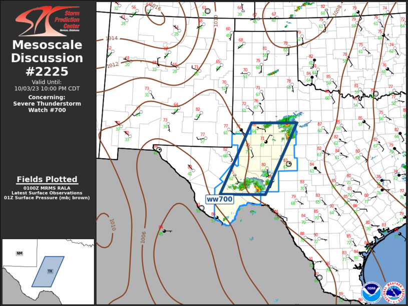
MD 2225 CONCERNING TORNADO WATCH 638… FOR SOUTHEAST TX INTO THE LOWER MISSISSIPPI VALLEY Mesoscale Discussion 2225 NWS Storm Prediction Center Norman OK 0601 PM CST Mon Nov 24 2025 Areas affected…Southeast TX into the lower Mississippi Valley Concerning…Tornado Watch 638… Valid 250001Z – 250130Z The severe weather threat for Tornado Watch 638 continues. SUMMARY…Scattered …
Continue reading SPC MD 2225
SPC Tornado Watch 638 Status Reports

WW 0638 Status Updates STATUS REPORT ON WW 638 SEVERE WEATHER THREAT CONTINUES RIGHT OF A LINE FROM 35 WNW CLL TO 35 NNE CLL TO 50 NW LFK TO 5 NW GGG. ..JEWELL..11/24/25 ATTN…WFO…SHV…FWD…HGX…LCH… STATUS REPORT FOR WT 638 SEVERE WEATHER THREAT CONTINUES FOR THE FOLLOWING AREAS LAC031-081-085-250040- LA . LOUISIANA PARISHES INCLUDED ARE …
Continue reading SPC Tornado Watch 638 Status Reports
SPC Tornado Watch 638
WW 638 TORNADO LA TX 241745Z – 250100Z URGENT – IMMEDIATE BROADCAST REQUESTED Tornado Watch Number 638 NWS Storm Prediction Center Norman OK 1145 AM CST Mon Nov 24 2025 The NWS Storm Prediction Center has issued a * Tornado Watch for portions of Extreme west central Louisiana Southeast and east central Texas * Effective …
Continue reading SPC Tornado Watch 638
SPC MD 2224
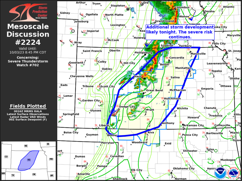
MD 2224 CONCERNING TORNADO WATCH 638… FOR PORTIONS OF EASTERN TEXAS INTO EXTREME WESTERN LOUISIANA Mesoscale Discussion 2224 NWS Storm Prediction Center Norman OK 0347 PM CST Mon Nov 24 2025 Areas affected…portions of eastern Texas into extreme western Louisiana Concerning…Tornado Watch 638… Valid 242147Z – 242315Z The severe weather threat for Tornado Watch 638 …
Continue reading SPC MD 2224
SPC MD 2223

MD 2223 CONCERNING TORNADO WATCH 638… FOR PORTIONS OF EAST-CENTRAL INTO SOUTHEAST TEXAS Mesoscale Discussion 2223 NWS Storm Prediction Center Norman OK 0107 PM CST Mon Nov 24 2025 Areas affected…portions of east-central into southeast Texas Concerning…Tornado Watch 638… Valid 241907Z – 242030Z The severe weather threat for Tornado Watch 638 continues. SUMMARY…A few tornadoes …
Continue reading SPC MD 2223