
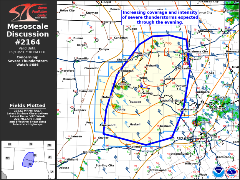
MD 2164 CONCERNING SEVERE POTENTIAL…WATCH POSSIBLE FOR NORTHWEST TEXAS INTO SOUTHWEST OKLAHOMA
Mesoscale Discussion 2164
NWS Storm Prediction Center Norman OK
0320 PM CDT Thu Oct 23 2025
Areas affected...northwest Texas into southwest Oklahoma
Concerning...Severe potential...Watch possible
Valid 232020Z - 232245Z
Probability of Watch Issuance...40 percent
SUMMARY...Several storms are expected to develop by late afternoon,
and a few may produce hail over 1.00" diameter along with strong
gusts.
DISCUSSION...A midlevel disturbance is currently moving across the
TX Panhandle, with thick clouds and light precipitation. A pocket of
cooler temperatures exists in this area, with minimal surface wind
shift noted. Just east of this activity, a substantial warm sector
continues to develop from TX into OK, with temperatures into the 80s
and upper 50s to lower 60s F dewpoints contributing to MLCAPE over
1500 J/kg. Further, a plume of PWAT to 1.30" extends as far north as
the Wichita Falls vicinity.
Visible satellite imagery shows strong heating ahead of the TX
Panhandle disturbance, with substantial cumulus noted from northern
TX into parts of southern OK. This uncapped air mass should
eventually yield at least isolated storms later this afternoon,
possibly supported by the existing differential heating zone and
weak surface convergence moving in from the west. Wind fields are
not particularly strong, with 20-30 kt midlevel speeds on the 18Z
AMA sounding. Initial activity may trend toward multicellular, with
some increasing supercell risk later this evening as low-level winds
increase.
..Jewell/Mosier.. 10/23/2025
...Please see www.spc.noaa.gov for graphic product...
ATTN...WFO...FWD...OUN...SJT...LUB...
LAT...LON   34599761 33679770 33229796 32929828 32809881 32809953
            33020028 33480033 33969980 34839937 35219907 35429845
            35369798 35169769 34599761
MOST PROBABLE PEAK TORNADO INTENSITY...UP TO 95 MPH
MOST PROBABLE PEAK WIND GUST...UP TO 60 MPH
MOST PROBABLE PEAK HAIL SIZE...1.50-2.50 IN