
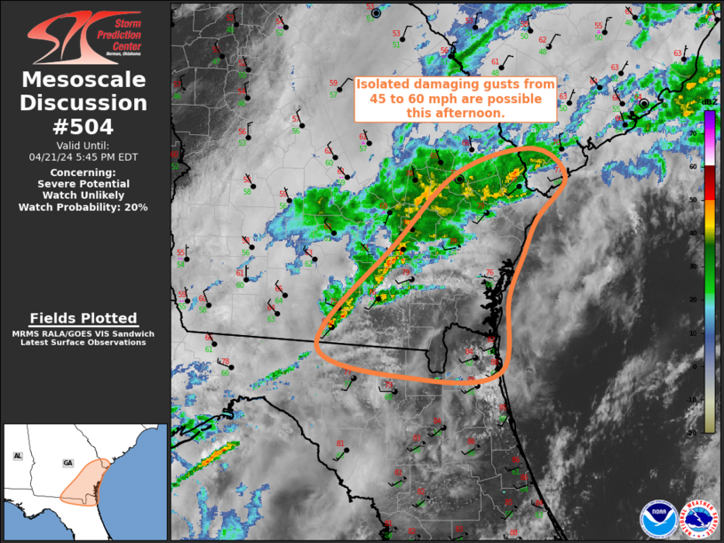
MD 0504 CONCERNING SEVERE POTENTIAL…WATCH UNLIKELY FOR SOUTHEAST GA…FAR NORTHEAST FL
Mesoscale Discussion 0504
NWS Storm Prediction Center Norman OK
0245 PM CDT Sun Apr 21 2024
Areas affected…Southeast GA…Far Northeast FL
Concerning…Severe potential…Watch unlikely
Valid 211945Z – 212145Z
Probability of Watch Issuance…20 percent
SUMMARY…Ongoing convective line may produce isolated damaging
gusts from 45 to 60 mph as it continue eastward across southeast
Georgia and far northeast Florida.
DISCUSSION…Recent regional radar imagery has shown an increase in
intensity of the convective line that extends from extreme southern
SC southwestward across southeast GA, just ahead of a
southeastward-progressing cold front. Modest buoyancy exists
downstream of this line, supported by surface temperatures in the
upper 70s and dewpoints in the mid 60s. Additionally, a shortwave
trough is moving quickly across the Southeast, contributing to
increasing large-scale ascent and deep-layer vertical shear across
the region. These factors are expected to result in maintenance, or
perhaps even some modest strengthening, of the ongoing line as it
moves eastward. Primary threat from this line is isolated damaging
gusts from 45 to 60 mph. Limited spatial extent and intensity of
this threat is expected to preclude the need for a watch.
..Mosier/Smith.. 04/21/2024
…Please see www.spc.noaa.gov for graphic product…
ATTN…WFO…CHS…JAX…FFC…TAE…
LAT…LON 31608254 32278187 32488103 32208068 31818100 31468115
31058131 30358141 30298227 30608344 31608254