
WW 301 SEVERE TSTM IA IL WI LM 241105Z – 241800Z
URGENT – IMMEDIATE BROADCAST REQUESTED
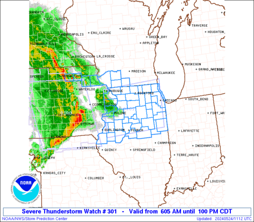
Severe Thunderstorm Watch Number 301
NWS Storm Prediction Center Norman OK
605 AM CDT Fri May 24 2024
The NWS Storm Prediction Center has issued a
* Severe Thunderstorm Watch for portions of
Eastern and northeastern Iowa
Northern Illinois
Southwestern Wisconsin
Lake Michigan
* Effective this Friday morning and afternoon from 605 AM until
100 PM CDT.
* Primary threats include…
Scattered damaging winds likely with isolated significant gusts
to 75 mph possible
Isolated large hail events to 1.5 inches in diameter possible
A tornado or two possible
SUMMARY…A well-organized squall line, preceded by isolated
strong-severe thunderstorms, should continue to move across Iowa and
the Mississippi River into adjoining parts of Illinois and
southwestern Wisconsin through midday. Damaging to severe gusts
should continue, along with a threat for a brief/embedded tornado or
two.
The severe thunderstorm watch area is approximately along and 70
statute miles north and south of a line from 20 miles west of Moline
IL to 55 miles east northeast of Marseilles IL. For a complete
depiction of the watch see the associated watch outline update
(WOUS64 KWNS WOU1).
PRECAUTIONARY/PREPAREDNESS ACTIONS…
REMEMBER…A Severe Thunderstorm Watch means conditions are
favorable for severe thunderstorms in and close to the watch area.
Persons in these areas should be on the lookout for threatening
weather conditions and listen for later statements and possible
warnings. Severe thunderstorms can and occasionally do produce
tornadoes.
&&
OTHER WATCH INFORMATION…CONTINUE…WW 300…
AVIATION…A few severe thunderstorms with hail surface and aloft to
1.5 inches. Extreme turbulence and surface wind gusts to 65 knots. A
few cumulonimbi with maximum tops to 500. Mean storm motion vector
26040.
…Edwards