
WW 461 SEVERE TSTM IA KS MO NE 260440Z – 261200Z
URGENT – IMMEDIATE BROADCAST REQUESTED
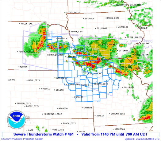
Severe Thunderstorm Watch Number 461
NWS Storm Prediction Center Norman OK
1140 PM CDT Tue Jun 25 2024
The NWS Storm Prediction Center has issued a
* Severe Thunderstorm Watch for portions of
Southwest Iowa
Northeast and East-Central Kansas
Northern and Western Missouri
Eastern Nebraska
* Effective this Tuesday night and Wednesday morning from 1140 PM
until 700 AM CDT.
* Primary threats include…
Scattered damaging winds likely with isolated significant gusts
to 75 mph possible
Scattered large hail likely with isolated very large hail events
to 2 inches in diameter possible
A tornado or two possible
SUMMARY…Supercell thunderstorms will continue to pose a threat for
large hail around 1-2 inches in diameter overnight. The threat for
severe/damaging winds up to 60-75 mph will likely increase as an
intense bowing cluster forms and moves southeastward through the
early morning hours.
The severe thunderstorm watch area is approximately along and 75
statute miles north and south of a line from 30 miles west southwest
of Lincoln NE to 40 miles southeast of Chillicothe MO. For a
complete depiction of the watch see the associated watch outline
update (WOUS64 KWNS WOU1).
PRECAUTIONARY/PREPAREDNESS ACTIONS…
REMEMBER…A Severe Thunderstorm Watch means conditions are
favorable for severe thunderstorms in and close to the watch area.
Persons in these areas should be on the lookout for threatening
weather conditions and listen for later statements and possible
warnings. Severe thunderstorms can and occasionally do produce
tornadoes.
&&
OTHER WATCH INFORMATION…CONTINUE…WW 459…WW 460…
AVIATION…A few severe thunderstorms with hail surface and aloft to
2 inches. Extreme turbulence and surface wind gusts to 65 knots. A
few cumulonimbi with maximum tops to 550. Mean storm motion vector
31035.
…Gleason