
WW 117 TORNADO IA IL MO WI 161705Z – 170100Z
URGENT – IMMEDIATE BROADCAST REQUESTED
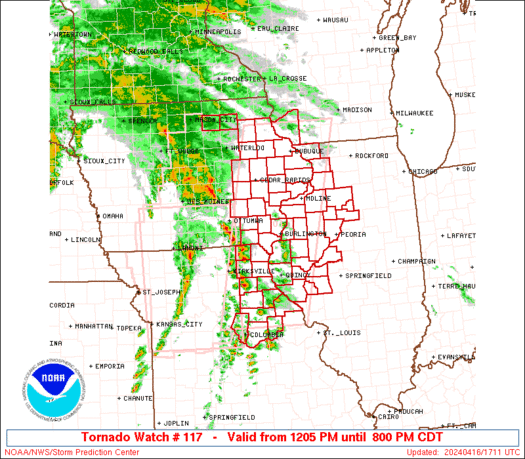
Tornado Watch Number 117
NWS Storm Prediction Center Norman OK
1205 PM CDT Tue Apr 16 2024
The NWS Storm Prediction Center has issued a
* Tornado Watch for portions of
Eastern Iowa
Western and Northwest Illinois
Northeast Missouri
Southwest Wisconsin
* Effective this Tuesday afternoon and evening from 1205 PM until
800 PM CDT.
* Primary threats include…
A few tornadoes likely with a couple intense tornadoes possible
Scattered damaging wind gusts to 70 mph likely
Scattered large hail and isolated very large hail events to 2
inches in diameter possible
SUMMARY…Arcing bands and clusters of severe storms including
supercells will steadily move northeastward across the region
through the afternoon, with the potential for all hazards including
tornadoes, a couple of which could be strong.
The tornado watch area is approximately along and 60 statute miles
east and west of a line from 40 miles north of Dubuque IA to 75
miles south southwest of Quincy IL. For a complete depiction of the
watch see the associated watch outline update (WOUS64 KWNS WOU7).
PRECAUTIONARY/PREPAREDNESS ACTIONS…
REMEMBER…A Tornado Watch means conditions are favorable for
tornadoes and severe thunderstorms in and close to the watch
area. Persons in these areas should be on the lookout for
threatening weather conditions and listen for later statements
and possible warnings.
&&
OTHER WATCH INFORMATION…CONTINUE…WW 116…
AVIATION…Tornadoes and a few severe thunderstorms with hail
surface and aloft to 2 inches. Extreme turbulence and surface wind
gusts to 60 knots. A few cumulonimbi with maximum tops to 500. Mean
storm motion vector 23040.
…Guyer