
WW 120 TORNADO IL WI 162250Z – 170300Z
URGENT – IMMEDIATE BROADCAST REQUESTED
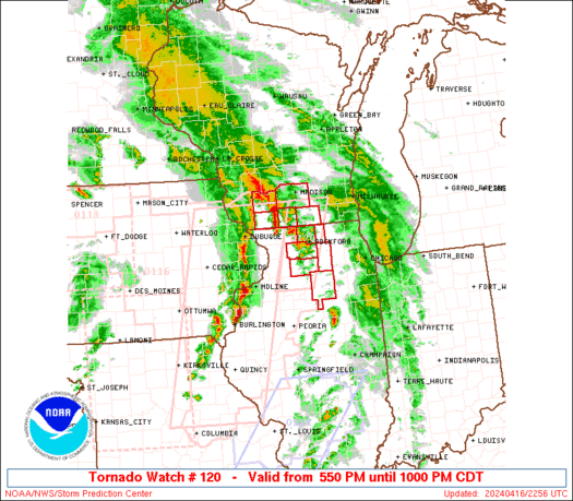
Tornado Watch Number 120
NWS Storm Prediction Center Norman OK
550 PM CDT Tue Apr 16 2024
The NWS Storm Prediction Center has issued a
* Tornado Watch for portions of
Northern Illinois
Southern Wisconsin
* Effective this Tuesday afternoon and evening from 550 PM until
1000 PM CDT.
* Primary threats include…
A couple tornadoes possible
Scattered damaging wind gusts to 70 mph possible
Scattered large hail events to 1.5 inches in diameter possible
SUMMARY…Scattered storm clusters and a couple of supercells will
be possible this evening into north central Illinois and south
central Wisconsin near a surface warm front. A couple of tornadoes,
damaging gusts of 60-70 mph and large hail of 1-1.5 inches in
diameter will all be possible through late evening.
The tornado watch area is approximately along and 25 statute miles
east and west of a line from 25 miles north of Janesville WI to 65
miles south southwest of Rockford IL. For a complete depiction of
the watch see the associated watch outline update (WOUS64 KWNS
WOU0).
PRECAUTIONARY/PREPAREDNESS ACTIONS…
REMEMBER…A Tornado Watch means conditions are favorable for
tornadoes and severe thunderstorms in and close to the watch
area. Persons in these areas should be on the lookout for
threatening weather conditions and listen for later statements
and possible warnings.
&&
OTHER WATCH INFORMATION…CONTINUE…WW 116…WW 117…WW
118…WW 119…
AVIATION…Tornadoes and a few severe thunderstorms with hail
surface and aloft to 1.5 inches. Extreme turbulence and surface wind
gusts to 60 knots. A few cumulonimbi with maximum tops to 500. Mean
storm motion vector 23035.
…Thompson