
WW 520 TORNADO ME NH 102155Z – 110400Z
URGENT – IMMEDIATE BROADCAST REQUESTED
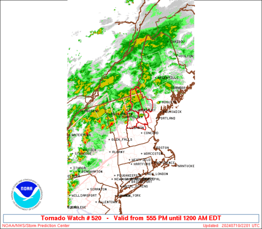
Tornado Watch Number 520
NWS Storm Prediction Center Norman OK
555 PM EDT Wed Jul 10 2024
The NWS Storm Prediction Center has issued a
* Tornado Watch for portions of
Western Maine
Northern and Central New Hampshire
* Effective this Wednesday afternoon from 555 PM until Midnight
EDT.
* Primary threats include…
A couple tornadoes possible
Isolated damaging wind gusts to 70 mph possible
SUMMARY…Thunderstorms will spread eastward from Vermont through
this evening. The strongest activity should pose some threat for a
couple of tornadoes, along with strong to locally damaging winds.
The tornado watch area is approximately along and 50 statute miles
north and south of a line from 35 miles west of Mount Washington NH
to 30 miles east of Mount Washington NH. For a complete depiction of
the watch see the associated watch outline update (WOUS64 KWNS
WOU0).
PRECAUTIONARY/PREPAREDNESS ACTIONS…
REMEMBER…A Tornado Watch means conditions are favorable for
tornadoes and severe thunderstorms in and close to the watch
area. Persons in these areas should be on the lookout for
threatening weather conditions and listen for later statements
and possible warnings.
&&
OTHER WATCH INFORMATION…CONTINUE…WW 517…WW 518…WW 519…
AVIATION…Tornadoes and a few severe thunderstorms with hail
surface and aloft to 1 inch. Extreme turbulence and surface wind
gusts to 60 knots. A few cumulonimbi with maximum tops to 500. Mean
storm motion vector 25030.
…Gleason