
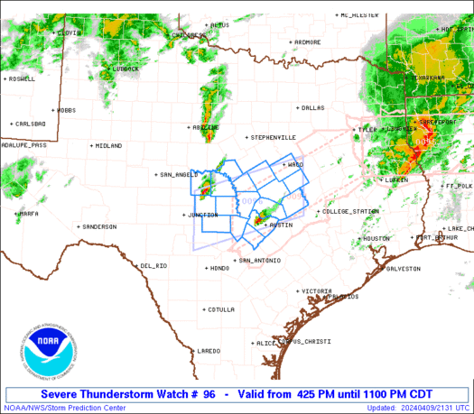
WW 0096 Status Updates STATUS REPORT ON WW 96 SEVERE WEATHER THREAT CONTINUES RIGHT OF A LINE FROM 35 ESE AUS TO 20 ENE TPL TO 30 NE ACT. WW 96 WILL BE ALLOWED TO EXPIRE AT 100400Z. FOR ADDITIONAL INFORMATION SEE MESOSCALE DISCUSSION 0407 ..DEAN..04/10/24 ATTN…WFO…FWD…EWX…SJT… STATUS REPORT FOR WS 96 SEVERE WEATHER THREAT …
Continue reading SPC Severe Thunderstorm Watch 96 Status Reports
Month:April 2024
SPC MD 406
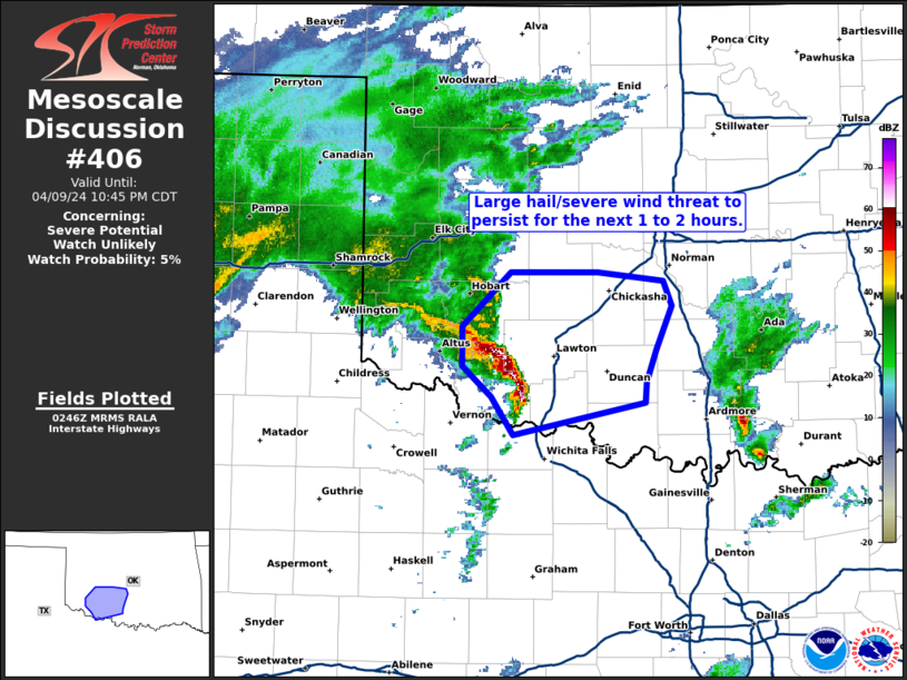
MD 0406 CONCERNING SEVERE POTENTIAL…WATCH UNLIKELY FOR SOUTHWEST OKLAHOMA INTO SOUTH-CENTRAL OKLAHOMA Mesoscale Discussion 0406 NWS Storm Prediction Center Norman OK 0949 PM CDT Tue Apr 09 2024 Areas affected…southwest Oklahoma into south-central Oklahoma Concerning…Severe potential…Watch unlikely Valid 100249Z – 100345Z Probability of Watch Issuance…5 percent SUMMARY…A large hail and severe wind threat will persist …
Continue reading SPC MD 406
SPC MD 407

MD 0407 CONCERNING SEVERE THUNDERSTORM WATCH 96…98… FOR PARTS OF SOUTH AND SOUTHEAST TX Mesoscale Discussion 0407 NWS Storm Prediction Center Norman OK 1012 PM CDT Tue Apr 09 2024 Areas affected…Parts of south and southeast TX Concerning…Severe Thunderstorm Watch 96…98… Valid 100312Z – 100445Z The severe weather threat for Severe Thunderstorm Watch 96, 98 …
Continue reading SPC MD 407
SPC Severe Thunderstorm Watch 98
WW 98 SEVERE TSTM TX CW 100135Z – 100900Z URGENT – IMMEDIATE BROADCAST REQUESTED Severe Thunderstorm Watch Number 98 NWS Storm Prediction Center Norman OK 835 PM CDT Tue Apr 9 2024 The NWS Storm Prediction Center has issued a * Severe Thunderstorm Watch for portions of Central and South Texas Coastal Waters * Effective …
Continue reading SPC Severe Thunderstorm Watch 98
SPC MD 403

MD 0403 CONCERNING SEVERE POTENTIAL…WATCH POSSIBLE FOR SOUTHEAST TEXAS INTO SOUTHWEST LOUISIANA Mesoscale Discussion 0403 NWS Storm Prediction Center Norman OK 0732 PM CDT Tue Apr 09 2024 Areas affected…southeast Texas into southwest Louisiana Concerning…Severe potential…Watch possible Valid 100032Z – 100200Z Probability of Watch Issuance…40 percent SUMMARY…Strong storms have developed across southeast Texas. A watch …
Continue reading SPC MD 403
SPC MD 404
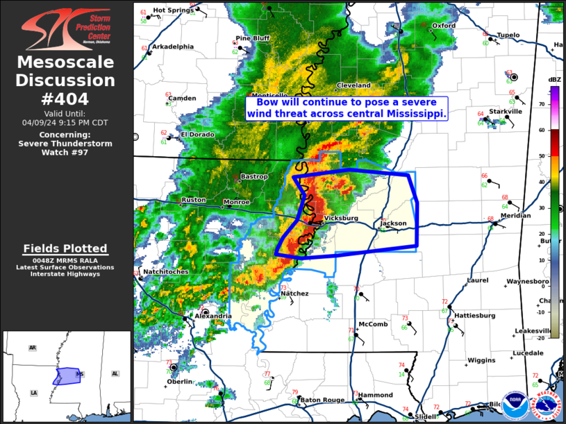
MD 0404 CONCERNING SEVERE THUNDERSTORM WATCH 97… FOR CENTRAL MISSISSIPPI Mesoscale Discussion 0404 NWS Storm Prediction Center Norman OK 0749 PM CDT Tue Apr 09 2024 Areas affected…central Mississippi Concerning…Severe Thunderstorm Watch 97… Valid 100049Z – 100215Z The severe weather threat for Severe Thunderstorm Watch 97 continues. SUMMARY…A bowing line of storms will continue to …
Continue reading SPC MD 404
SPC MD 405
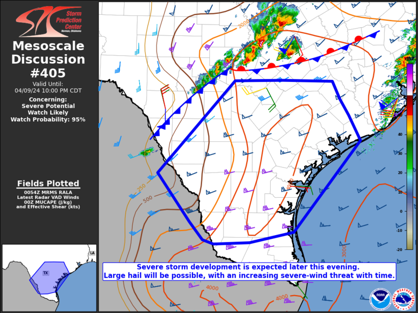
MD 0405 CONCERNING SEVERE POTENTIAL…WATCH LIKELY FOR PARTS OF SOUTH TX Mesoscale Discussion 0405 NWS Storm Prediction Center Norman OK 0757 PM CDT Tue Apr 09 2024 Areas affected…Parts of south TX Concerning…Severe potential…Watch likely Valid 100057Z – 100300Z Probability of Watch Issuance…95 percent SUMMARY…Severe storm development is expected later this evening. Large hail will …
Continue reading SPC MD 405
SPC Tornado Watch 95 Status Reports
WW 0095 Status Updates STATUS REPORT ON WW 95 SEVERE WEATHER THREAT CONTINUES RIGHT OF A LINE FROM 15 SE LFK TO 45 W IER TO 35 SW MLU TO 30 S LLQ. FOR ADDITIONAL INFORMATION SEE MESOSCALE DISCUSSION 0401 ..WEINMAN..04/09/24 ATTN…WFO…SHV… STATUS REPORT FOR WT 95 SEVERE WEATHER THREAT CONTINUES FOR THE FOLLOWING AREAS …
Continue reading SPC Tornado Watch 95 Status Reports
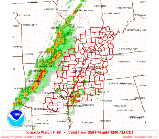
SPC Tornado Watch 95
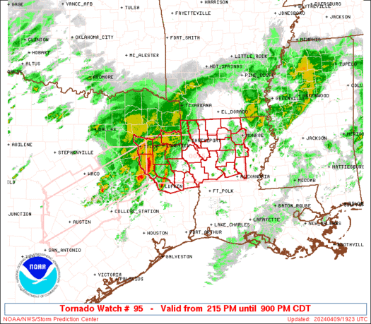
WW 95 TORNADO LA TX 091915Z – 100200Z URGENT – IMMEDIATE BROADCAST REQUESTED Tornado Watch Number 95 NWS Storm Prediction Center Norman OK 215 PM CDT Tue Apr 9 2024 The NWS Storm Prediction Center has issued a * Tornado Watch for portions of Northern Louisiana East Texas * Effective this Tuesday afternoon and evening …
Continue reading SPC Tornado Watch 95
SPC Severe Thunderstorm Watch 97 Status Reports

WW 0097 Status Updates STATUS REPORT ON WW 97 THE SEVERE WEATHER THREAT CONTINUES ACROSS THE ENTIRE WATCH AREA. ..WEINMAN..04/09/24 ATTN…WFO…JAN… STATUS REPORT FOR WS 97 SEVERE WEATHER THREAT CONTINUES FOR THE FOLLOWING AREAS LAC025-029-035-041-065-067-083-107-123-100040- LA . LOUISIANA PARISHES INCLUDED ARE CATAHOULA CONCORDIA EAST CARROLL FRANKLIN MADISON MOREHOUSE RICHLAND TENSAS WEST CARROLL THE WATCH STATUS …
Continue reading SPC Severe Thunderstorm Watch 97 Status Reports