

WW 290 SEVERE TSTM AR LA TX 222155Z – 230400Z URGENT – IMMEDIATE BROADCAST REQUESTED Severe Thunderstorm Watch Number 290 NWS Storm Prediction Center Norman OK 455 PM CDT Wed May 22 2024 The NWS Storm Prediction Center has issued a * Severe Thunderstorm Watch for portions of Southern Arkansas Northwest Louisiana Northeast Texas * …
Continue reading SPC Severe Thunderstorm Watch 290
Month:May 2024
SPC Tornado Watch 291

WW 291 TORNADO TX 222340Z – 230500Z URGENT – IMMEDIATE BROADCAST REQUESTED Tornado Watch Number 291 NWS Storm Prediction Center Norman OK 640 PM CDT Wed May 22 2024 The NWS Storm Prediction Center has issued a * Tornado Watch for portions of Central and southeast Texas * Effective this Wednesday night from 640 PM …
Continue reading SPC Tornado Watch 291
SPC Severe Thunderstorm Watch 284 Status Reports
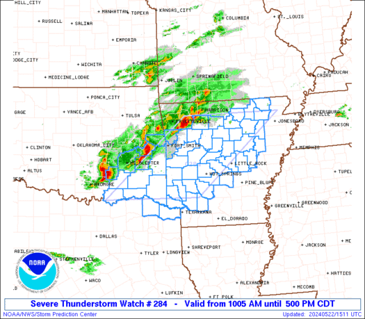
WW 0284 Status Updates STATUS REPORT ON WW 284 SEVERE WEATHER THREAT CONTINUES RIGHT OF A LINE FROM 40 W TXK TO 15 S DEQ TO 20 NW RUE TO 20 ENE FLP. ..BROYLES..05/22/24 ATTN…WFO…LZK…TSA…SHV…OUN… STATUS REPORT FOR WS 284 SEVERE WEATHER THREAT CONTINUES FOR THE FOLLOWING AREAS ARC001-013-019-023-025-029-039-045-051-053-057-059-061-063-065- 067-069-075-079-081-085-095-097-099-103-105-109-115-117-119-121- 125-129-135-137-141-145-147-149-222240- AR . ARKANSAS COUNTIES …
Continue reading SPC Severe Thunderstorm Watch 284 Status Reports
Apple’s 2024 M4 Mac Mini: What We Know
Apple is working to refresh the entire Mac lineup with chips in the M4 series, and the Mac mini could get an update as soon as late 2024. Apple is expected to skip the M3 chip, going straight from M2 to M4. This guide highlights everything that we know about the Mac mini refresh so …
Continue reading Apple’s 2024 M4 Mac Mini: What We Know
Review: Anker’s Latest 3-in-1 Power Bank is a Versatile On-the-Go Powerhouse
Popular accessory brand Anker has just launched a new 10K version of its 3-in-1 power bank that offers up to 30 watts of charging power, a convenient display to quickly view exact charge status, an integrated USB-C cable for both input and output, and built-in folding prongs to recharge directly from a power outlet. I’ve …
Continue reading Review: Anker’s Latest 3-in-1 Power Bank is a Versatile On-the-Go Powerhouse
Disney Shares Trailer for Immersive Vision Pro Marvel Story
Disney today shared a trailer for the hour-long interactive and immersive Disney+ Marvel story that is set to come to the Vision Pro on Thursday, May 30. The Disney+ original from Marvel Studios is connected to the “What If…?” animated series and it will be released as a standalone app for the Vision Pro.What If… …
Continue reading Disney Shares Trailer for Immersive Vision Pro Marvel Story
SPC Severe Thunderstorm Watch 288

WW 288 SEVERE TSTM MD NY PA VA WV LO CW 221900Z – 230000Z URGENT – IMMEDIATE BROADCAST REQUESTED Severe Thunderstorm Watch Number 288 NWS Storm Prediction Center Norman OK 300 PM EDT Wed May 22 2024 The NWS Storm Prediction Center has issued a * Severe Thunderstorm Watch for portions of Central Maryland Central …
Continue reading SPC Severe Thunderstorm Watch 288
What the Golf on Apple Vision Pro Gains New Levels
Popular Apple Arcade game What the Golf? for the Vision Pro is being updated with a slew of new content, with Apple adding 15 new areas with more than 100 spatial levels and 200 challenges to complete. What the Golf? is, as the name suggests, a mini golf game aimed at people who hate golf. …
Continue reading What the Golf on Apple Vision Pro Gains New Levels
SPC MD 890

MD 0890 CONCERNING SEVERE POTENTIAL…WATCH LIKELY FOR NORTHEAST AR…WESTERN AND MIDDLE TN…NORTHWEST MS…FAR SOUTHWEST KY Mesoscale Discussion 0890 NWS Storm Prediction Center Norman OK 1126 AM CDT Wed May 22 2024 Areas affected…Northeast AR…Western and Middle TN…Northwest MS… Far Southwest KY Concerning…Severe potential…Watch likely Valid 221626Z – 221830Z Probability of Watch Issuance…80 percent SUMMARY…Increasing thunderstorm …
Continue reading SPC MD 890
SPC MD 891
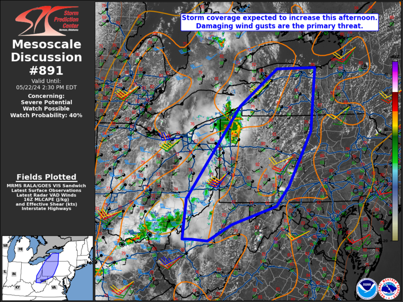
MD 0891 CONCERNING SEVERE POTENTIAL…WATCH POSSIBLE FOR WESTERN NEW YORK INTO PARTS UPPER OHIO VALLEY Mesoscale Discussion 0891 NWS Storm Prediction Center Norman OK 1128 AM CDT Wed May 22 2024 Areas affected…Western New York into parts upper Ohio Valley Concerning…Severe potential…Watch possible Valid 221628Z – 221830Z Probability of Watch Issuance…40 percent SUMMARY…A severe thunderstorm …
Continue reading SPC MD 891