
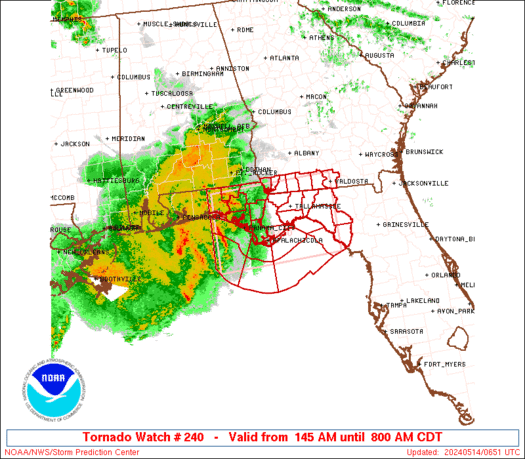
WW 240 TORNADO FL GA CW 140645Z – 141300Z URGENT – IMMEDIATE BROADCAST REQUESTED Tornado Watch Number 240 NWS Storm Prediction Center Norman OK 145 AM CDT Tue May 14 2024 The NWS Storm Prediction Center has issued a * Tornado Watch for portions of Northern Florida Far Southern Georgia Coastal Waters * Effective this …
Continue reading SPC Tornado Watch 240
Month:May 2024
SPC MD 776

MD 0776 CONCERNING SEVERE POTENTIAL…WATCH POSSIBLE FOR COASTAL FLORIDA PANHANDLE Mesoscale Discussion 0776 NWS Storm Prediction Center Norman OK 1134 PM CDT Mon May 13 2024 Areas affected…Coastal Florida Panhandle Concerning…Severe potential…Watch possible Valid 140434Z – 140630Z Probability of Watch Issuance…40 percent SUMMARY…Low risk for damaging winds, and perhaps a brief tornado, with convection early …
Continue reading SPC MD 776
SPC Severe Thunderstorm Watch 239 Status Reports
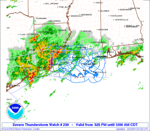
WW 0239 Status Updates STATUS REPORT ON WW 239 SEVERE WEATHER THREAT CONTINUES RIGHT OF A LINE FROM 35 S HUM TO 40 NNE ASD. ..SPC..05/14/24 ATTN…WFO…LCH…LIX… STATUS REPORT FOR WS 239 SEVERE WEATHER THREAT CONTINUES FOR THE FOLLOWING AREAS LAC051-057-071-075-087-140340- LA . LOUISIANA PARISHES INCLUDED ARE JEFFERSON LAFOURCHE ORLEANS PLAQUEMINES ST. BERNARD MSC045-047-059-109-140340- MS …
Continue reading SPC Severe Thunderstorm Watch 239 Status Reports
SPC MD 775

MD 0775 CONCERNING SEVERE THUNDERSTORM WATCH 239… FOR CENTRAL GULF COAST VICINITY Mesoscale Discussion 0775 NWS Storm Prediction Center Norman OK 0825 PM CDT Mon May 13 2024 Areas affected…Central Gulf Coast Vicinity Concerning…Severe Thunderstorm Watch 239… Valid 140125Z – 140330Z The severe weather threat for Severe Thunderstorm Watch 239 continues. SUMMARY…Severe threat will shift …
Continue reading SPC MD 775
SPC Severe Thunderstorm Watch 238 Status Reports
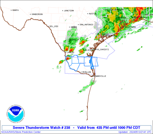
WW 0238 Status Updates STATUS REPORT ON WW 238 SEVERE WEATHER THREAT CONTINUES RIGHT OF A LINE FROM 80 W MFE TO 50 ESE LRD. ..SPC..05/14/24 ATTN…WFO…BRO… STATUS REPORT FOR WS 238 SEVERE WEATHER THREAT CONTINUES FOR THE FOLLOWING AREAS TXC047-061-215-247-261-427-489-140140- TX . TEXAS COUNTIES INCLUDED ARE BROOKS CAMERON HIDALGO JIM HOGG KENEDY STARR WILLACY …
Continue reading SPC Severe Thunderstorm Watch 238 Status Reports
SPC MD 773

MD 0773 CONCERNING SEVERE POTENTIAL…WATCH UNLIKELY FOR MO OZARKS TO OUACHITA MOUNTAINS Mesoscale Discussion 0773 NWS Storm Prediction Center Norman OK 0616 PM CDT Mon May 13 2024 Areas affected…MO Ozarks to Ouachita Mountains Concerning…Severe potential…Watch unlikely Valid 132316Z – 140115Z Probability of Watch Issuance…20 percent SUMMARY…Some risk for marginally severe hail and gusty winds …
Continue reading SPC MD 773
SPC MD 774
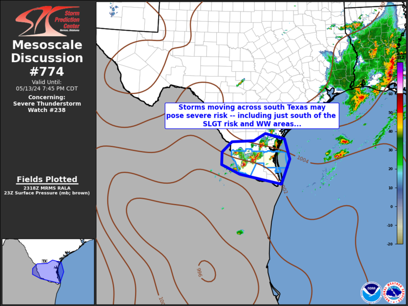
MD 0774 CONCERNING SEVERE THUNDERSTORM WATCH 238… FOR DEEP SOUTH TEXAS Mesoscale Discussion 0774 NWS Storm Prediction Center Norman OK 0620 PM CDT Mon May 13 2024 Areas affected…Deep South Texas Concerning…Severe Thunderstorm Watch 238… Valid 132320Z – 140045Z The severe weather threat for Severe Thunderstorm Watch 238 continues. SUMMARY…Strong/locally severe storms continue across Deep …
Continue reading SPC MD 774
SPC Severe Thunderstorm Watch 237 Status Reports
WW 0237 Status Updates STATUS REPORT ON WW 237 SEVERE WEATHER THREAT CONTINUES RIGHT OF A LINE FROM 20 N VCT TO 45 NNE VCT TO 50 W HOU TO 25 S UTS TO 25 NE UTS. FOR ADDITIONAL INFORMATION SEE MESOSCALE DISCUSSION 0770 ..GLEASON..05/13/24 ATTN…WFO…LCH…HGX… STATUS REPORT FOR WS 237 SEVERE WEATHER THREAT CONTINUES …
Continue reading SPC Severe Thunderstorm Watch 237 Status Reports
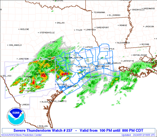
SPC Severe Thunderstorm Watch 237
WW 237 SEVERE TSTM LA TX CW 131800Z – 140100Z URGENT – IMMEDIATE BROADCAST REQUESTED Severe Thunderstorm Watch Number 237 NWS Storm Prediction Center Norman OK 100 PM CDT Mon May 13 2024 The NWS Storm Prediction Center has issued a * Severe Thunderstorm Watch for portions of Southwest Louisiana Southeast Texas Coastal Waters * …
Continue reading SPC Severe Thunderstorm Watch 237
SPC Severe Thunderstorm Watch 238
WW 238 SEVERE TSTM TX CW 132135Z – 140300Z URGENT – IMMEDIATE BROADCAST REQUESTED Severe Thunderstorm Watch Number 238 NWS Storm Prediction Center Norman OK 435 PM CDT Mon May 13 2024 The NWS Storm Prediction Center has issued a * Severe Thunderstorm Watch for portions of Deep South Texas Coastal Waters * Effective this …
Continue reading SPC Severe Thunderstorm Watch 238