

WW 0491 Status Updates STATUS REPORT ON WW 491 SEVERE WEATHER THREAT CONTINUES RIGHT OF A LINE FROM 20 NE RDU TO 35 SE CHO TO 15 NNW CHO. FOR ADDITIONAL INFORMATION SEE MESOSCALE DISCUSSION 1500 ..WEINMAN..07/01/24 ATTN…WFO…LWX…PHI…AKQ…RAH…RNK… STATUS REPORT FOR WS 491 SEVERE WEATHER THREAT CONTINUES FOR THE FOLLOWING AREAS DEC001-005-010140- DE . DELAWARE …
Continue reading SPC Severe Thunderstorm Watch 491 Status Reports
Month:July 2024
SPC MD 1500

MD 1500 CONCERNING SEVERE THUNDERSTORM WATCH 491… FOR PORTIONS OF EASTERN MARYLAND INTO SOUTHERN NEW JERSEY…DELAWARE…EASTERN VIRGINIA Mesoscale Discussion 1500 NWS Storm Prediction Center Norman OK 0710 PM CDT Sun Jun 30 2024 Areas affected…portions of eastern Maryland into southern New Jersey…Delaware…eastern Virginia Concerning…Severe Thunderstorm Watch 491… Valid 010010Z – 010145Z The severe weather threat …
Continue reading SPC MD 1500
SPC MD 1501

MD 1501 CONCERNING SEVERE THUNDERSTORM WATCH 492… FOR SOUTHERN AND EASTERN MT Mesoscale Discussion 1501 NWS Storm Prediction Center Norman OK 0714 PM CDT Sun Jun 30 2024 Areas affected…southern and eastern MT Concerning…Severe Thunderstorm Watch 492… Valid 010014Z – 010145Z The severe weather threat for Severe Thunderstorm Watch 492 continues. SUMMARY…Ongoing marginal/isolated severe threat …
Continue reading SPC MD 1501
SPC Severe Thunderstorm Watch 490 Status Reports

WW 0490 Status Updates STATUS REPORT ON WW 490 SEVERE WEATHER THREAT CONTINUES RIGHT OF A LINE FROM 25 NNW EEN TO 10 ESE AUG TO 50 S HUL. ..WEINMAN..06/30/24 ATTN…WFO…GYX…CAR…BTV… STATUS REPORT FOR WS 490 SEVERE WEATHER THREAT CONTINUES FOR THE FOLLOWING AREAS MEC001-005-009-013-015-023-027-029-031-302240- ME . MAINE COUNTIES INCLUDED ARE ANDROSCOGGIN CUMBERLAND HANCOCK KNOX …
Continue reading SPC Severe Thunderstorm Watch 490 Status Reports
SPC Severe Thunderstorm Watch 491
WW 491 SEVERE TSTM DC DE MD NC NJ VA CW 301920Z – 010300Z URGENT – IMMEDIATE BROADCAST REQUESTED Severe Thunderstorm Watch Number 491 NWS Storm Prediction Center Norman OK 320 PM EDT Sun Jun 30 2024 The NWS Storm Prediction Center has issued a * Severe Thunderstorm Watch for portions of District Of Columbia …
Continue reading SPC Severe Thunderstorm Watch 491
SPC Severe Thunderstorm Watch 492

WW 492 SEVERE TSTM MT 302135Z – 010200Z URGENT – IMMEDIATE BROADCAST REQUESTED Severe Thunderstorm Watch Number 492 NWS Storm Prediction Center Norman OK 335 PM MDT Sun Jun 30 2024 The NWS Storm Prediction Center has issued a * Severe Thunderstorm Watch for portions of Southwest into Central Montana * Effective this Sunday afternoon …
Continue reading SPC Severe Thunderstorm Watch 492
SPC MD 1499

MD 1499 CONCERNING SEVERE POTENTIAL…WATCH UNLIKELY FOR PORTIONS OF CENTRAL INTO SOUTHERN SOUTH CAROLINA Mesoscale Discussion 1499 NWS Storm Prediction Center Norman OK 0524 PM CDT Sun Jun 30 2024 Areas affected…portions of central into southern South Carolina Concerning…Severe potential…Watch unlikely Valid 302224Z – 302330Z Probability of Watch Issuance…5 percent SUMMARY…A couple of strong/damaging gusts …
Continue reading SPC MD 1499
SPC MD 1497

MD 1497 CONCERNING SEVERE POTENTIAL…WATCH POSSIBLE FOR THE CENTRAL HIGH PLAINS Mesoscale Discussion 1497 NWS Storm Prediction Center Norman OK 0454 PM CDT Sun Jun 30 2024 Areas affected…the central High Plains Concerning…Severe potential…Watch possible Valid 302154Z – 302330Z Probability of Watch Issuance…40 percent SUMMARY…Isolated severe wind and hail threats should persist along and east …
Continue reading SPC MD 1497
SPC MD 1498

MD 1498 CONCERNING SEVERE THUNDERSTORM WATCH 491… FOR PORTION OF EASTERN MARYLAND AND VIRGINIA INTO DELAWARE Mesoscale Discussion 1498 NWS Storm Prediction Center Norman OK 0503 PM CDT Sun Jun 30 2024 Areas affected…portion of eastern Maryland and Virginia into Delaware Concerning…Severe Thunderstorm Watch 491… Valid 302203Z – 302330Z The severe weather threat for Severe …
Continue reading SPC MD 1498
SPC Severe Thunderstorm Watch 489 Status Reports
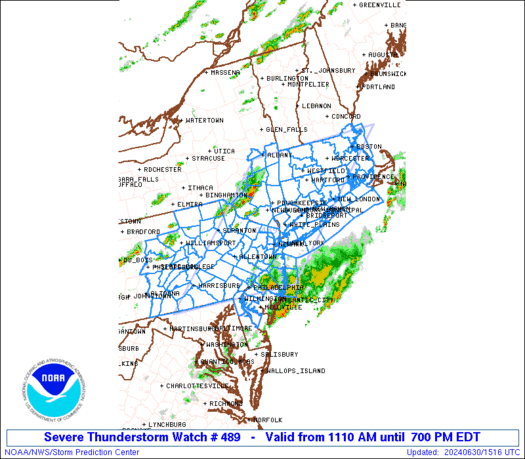
WW 0489 Status Updates STATUS REPORT ON WW 489 SEVERE WEATHER THREAT CONTINUES RIGHT OF A LINE FROM 10 SSW HGR TO 25 SSE AVP TO 20 E MSV TO 10 S CON. FOR ADDITIONAL INFORMATION SEE MESOSCALE DISCUSSION 1496 ..WEINMAN..06/30/24 ATTN…WFO…OKX…BOX…ALY…PHI…BGM…CTP… STATUS REPORT FOR WS 489 SEVERE WEATHER THREAT CONTINUES FOR THE FOLLOWING AREAS …
Continue reading SPC Severe Thunderstorm Watch 489 Status Reports