
WW 463 SEVERE TSTM AR KS MO OK 260910Z – 261600Z
URGENT – IMMEDIATE BROADCAST REQUESTED
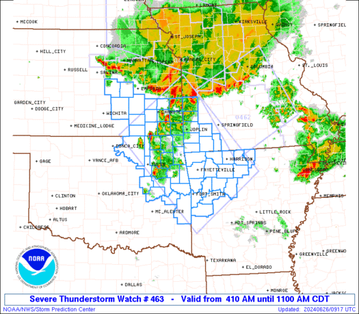
Severe Thunderstorm Watch Number 463
NWS Storm Prediction Center Norman OK
410 AM CDT Wed Jun 26 2024
The NWS Storm Prediction Center has issued a
* Severe Thunderstorm Watch for portions of
Northwestern Arkansas
Southeastern Kansas
Southwestern Missouri
Northeastern Oklahoma
* Effective this Wednesday morning from 410 AM until 1100 AM CDT.
* Primary threats include…
Scattered damaging wind gusts to 70 mph likely
Isolated large hail events to 1.5 inches in diameter possible
SUMMARY…Merging areas of strong-severe thunderstorms — already
with a history of severe wind in parts of NE, northeastern KS and
northwestern MO — should evolve into a new complex and move
southeastward over the 4-state area of the western Ozarks. Activity
may reach the Arkansas River Valley between Tulsa and the Ft. Smith
area while still potentially severe later this morning. Damaging
wind will remain the primary threat, with isolated large hail
possible predominantly ahead of the main complex.
The severe thunderstorm watch area is approximately along and 85
statute miles either side of a line from 20 miles northwest of
Chanute KS to 15 miles south southwest of Russellville AR. For a
complete depiction of the watch see the associated watch outline
update (WOUS64 KWNS WOU3).
PRECAUTIONARY/PREPAREDNESS ACTIONS…
REMEMBER…A Severe Thunderstorm Watch means conditions are
favorable for severe thunderstorms in and close to the watch area.
Persons in these areas should be on the lookout for threatening
weather conditions and listen for later statements and possible
warnings. Severe thunderstorms can and occasionally do produce
tornadoes.
&&
OTHER WATCH INFORMATION…CONTINUE…WW 461…WW 462…
AVIATION…A few severe thunderstorms with hail surface and aloft to
1.5 inches. Extreme turbulence and surface wind gusts to 60 knots. A
few cumulonimbi with maximum tops to 550. Mean storm motion vector
32040.
…Edwards