
WW 472 SEVERE TSTM MA RI CW 270155Z – 270600Z
URGENT – IMMEDIATE BROADCAST REQUESTED
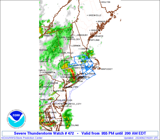
Severe Thunderstorm Watch Number 472
NWS Storm Prediction Center Norman OK
955 PM EDT Wed Jun 26 2024
The NWS Storm Prediction Center has issued a
* Severe Thunderstorm Watch for portions of
Central and Eastern Massachusetts
Rhode Island
Coastal Waters
* Effective this Wednesday night and Thursday morning from 955 PM
until 200 AM EDT.
* Primary threats include…
Scattered damaging wind gusts to 65 mph possible
SUMMARY…An organized squall line will continue east-northeast
across southern New England through the late evening and early
overnight. Widely scattered strong to severe gusts (50-65 mph) will
be possible with the more intense thunderstorm cores and embedded
surges in the squall line.
The severe thunderstorm watch area is approximately along and 45
statute miles north and south of a line from 40 miles southwest of
Worcester MA to 15 miles east southeast of New Bedford MA. For a
complete depiction of the watch see the associated watch outline
update (WOUS64 KWNS WOU2).
PRECAUTIONARY/PREPAREDNESS ACTIONS…
REMEMBER…A Severe Thunderstorm Watch means conditions are
favorable for severe thunderstorms in and close to the watch area.
Persons in these areas should be on the lookout for threatening
weather conditions and listen for later statements and possible
warnings. Severe thunderstorms can and occasionally do produce
tornadoes.
&&
OTHER WATCH INFORMATION…CONTINUE…WW 467…WW 468…WW
469…WW 470…WW 471…
AVIATION…A few severe thunderstorms with hail surface and aloft to
1 inch. Extreme turbulence and surface wind gusts to 55 knots. A few
cumulonimbi with maximum tops to 400. Mean storm motion vector
24045.
…Smith