
WW 513 TORNADO TX CW 080345Z – 081500Z
URGENT – IMMEDIATE BROADCAST REQUESTED
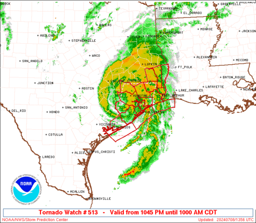
Tornado Watch Number 513
NWS Storm Prediction Center Norman OK
1045 PM CDT Sun Jul 7 2024
The NWS Storm Prediction Center has issued a
* Tornado Watch for portions of
Upper Texas Coast
Coastal Waters
* Effective this Sunday night and Monday morning from 1045 PM
until 1000 AM CDT.
* Primary threats include…
A couple tornadoes possible
Isolated damaging wind gusts to 70 mph possible
SUMMARY…Tropical Storm Beryl will move ashore overnight. Embedded
thunderstorms in the rainbands to the east of the center will pose a
risk of isolated tornadoes through Monday morning.
The tornado watch area is approximately along and 45 statute miles
east and west of a line from 50 miles south of Angleton TX to 60
miles north northeast of Houston TX. For a complete depiction of the
watch see the associated watch outline update (WOUS64 KWNS WOU3).
PRECAUTIONARY/PREPAREDNESS ACTIONS…
REMEMBER…A Tornado Watch means conditions are favorable for
tornadoes and severe thunderstorms in and close to the watch
area. Persons in these areas should be on the lookout for
threatening weather conditions and listen for later statements
and possible warnings.
&&
OTHER WATCH INFORMATION…CONTINUE…WW 511…WW 512…
AVIATION…Tornadoes and a few severe thunderstorms with hail
surface and aloft to 0.5 inches. Extreme turbulence and surface wind
gusts to 60 knots. A few cumulonimbi with maximum tops to 500. Mean
storm motion vector 14040.
…Hart