
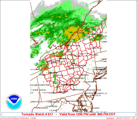
WW 517 TORNADO NY PA VT LE LO 101605Z – 110100Z
URGENT – IMMEDIATE BROADCAST REQUESTED
Tornado Watch Number 517
NWS Storm Prediction Center Norman OK
1205 PM EDT Wed Jul 10 2024
The NWS Storm Prediction Center has issued a
* Tornado Watch for portions of
Upstate New York
Northern and Central Pennsylvania
Vermont
Lake Erie
Lake Ontario
* Effective this Wednesday afternoon and evening from 1205 PM
until 900 PM EDT.
* Primary threats include…
A few tornadoes likely
Scattered damaging wind gusts to 70 mph possible
SUMMARY…A moist air mass along and south of a warm front, and
strong atmospheric winds associated with the remnants of Beryl, will
influence storms capable of tornadoes and wind damage this afternoon
through early/mid-evening.
The tornado watch area is approximately along and 90 statute miles
north and south of a line from 25 miles west southwest of Bradford
PA to 25 miles south southeast of Burlington VT. For a complete
depiction of the watch see the associated watch outline update
(WOUS64 KWNS WOU7).
PRECAUTIONARY/PREPAREDNESS ACTIONS…
REMEMBER…A Tornado Watch means conditions are favorable for
tornadoes and severe thunderstorms in and close to the watch
area. Persons in these areas should be on the lookout for
threatening weather conditions and listen for later statements
and possible warnings.
&&
AVIATION…Tornadoes and a few severe thunderstorms with hail
surface and aloft to 0.5 inches. Extreme turbulence and surface wind
gusts to 60 knots. A few cumulonimbi with maximum tops to 500. Mean
storm motion vector 24025.
…Guyer