

MD 1746 CONCERNING SEVERE POTENTIAL…WATCH POSSIBLE FOR EASTERN MISSOURI INTO SOUTHERN ILLINOIS Mesoscale Discussion 1746 NWS Storm Prediction Center Norman OK 0156 PM CDT Tue Jul 30 2024 Areas affected…eastern Missouri into southern Illinois Concerning…Severe potential…Watch possible Valid 301856Z – 302100Z Probability of Watch Issuance…60 percent SUMMARY…Severe potential is increasing this afternoon across eastern Missouri …
Continue reading SPC MD 1746
Category:Weather
SPC Severe Thunderstorm Watch 569 Status Reports

WW 0569 Status Updates STATUS REPORT ON WW 569 SEVERE WEATHER THREAT CONTINUES RIGHT OF A LINE FROM 25 SW OWB TO 45 NNE BWG TO 40 SSE SDF TO 20 W LEX. ..LEITMAN..07/30/24 ATTN…WFO…LMK…IND…PAH… STATUS REPORT FOR WS 569 SEVERE WEATHER THREAT CONTINUES FOR THE FOLLOWING AREAS KYC031-061-085-099-123-149-177-183-219-302040- KY . KENTUCKY COUNTIES INCLUDED ARE …
Continue reading SPC Severe Thunderstorm Watch 569 Status Reports
SPC MD 1745

MD 1745 CONCERNING SEVERE THUNDERSTORM WATCH 568… FOR FAR SOUTHEAST IOWA…NORTHEAST MISSOURI…AND WEST-CENTRAL IL Mesoscale Discussion 1745 NWS Storm Prediction Center Norman OK 1249 PM CDT Tue Jul 30 2024 Areas affected…far southeast Iowa…northeast Missouri…and west-central IL Concerning…Severe Thunderstorm Watch 568… Valid 301749Z – 301945Z The severe weather threat for Severe Thunderstorm Watch 568 continues. …
Continue reading SPC MD 1745
SPC Severe Thunderstorm Watch 570

WW 570 SEVERE TSTM KY TN 301820Z – 310100Z URGENT – IMMEDIATE BROADCAST REQUESTED Severe Thunderstorm Watch Number 570 NWS Storm Prediction Center Norman OK 220 PM EDT Tue Jul 30 2024 The NWS Storm Prediction Center has issued a * Severe Thunderstorm Watch for portions of Central and Eastern Kentucky Middle and Eastern Tennessee …
Continue reading SPC Severe Thunderstorm Watch 570
SPC MD 1744

MD 1744 CONCERNING SEVERE THUNDERSTORM WATCH 569… FOR SOUTHERN INDIANA INTO CENTRAL KENTUCKY Mesoscale Discussion 1744 NWS Storm Prediction Center Norman OK 1208 PM CDT Tue Jul 30 2024 Areas affected…southern Indiana into central Kentucky Concerning…Severe Thunderstorm Watch 569… Valid 301708Z – 301915Z The severe weather threat for Severe Thunderstorm Watch 569 continues. SUMMARY…Damaging wind …
Continue reading SPC MD 1744
SPC MD 1743

MD 1743 CONCERNING SEVERE POTENTIAL…WATCH UNLIKELY FOR PENNSYLVANIA…MARYLAND…AND VIRGINIA…INCLUDING WASHINGTON D.C. Mesoscale Discussion 1743 NWS Storm Prediction Center Norman OK 1139 AM CDT Tue Jul 30 2024 Areas affected…Pennsylvania…Maryland…and Virginia…including Washington D.C. Concerning…Severe potential…Watch unlikely Valid 301639Z – 301845Z Probability of Watch Issuance…20 percent SUMMARY…Initially isolated thunderstorms should increase in coverage through the afternoon hours …
Continue reading SPC MD 1743
SPC Severe Thunderstorm Watch 569
WW 569 SEVERE TSTM IN KY 301505Z – 302100Z URGENT – IMMEDIATE BROADCAST REQUESTED Severe Thunderstorm Watch Number 569 NWS Storm Prediction Center Norman OK 1005 AM CDT Tue Jul 30 2024 The NWS Storm Prediction Center has issued a * Severe Thunderstorm Watch for portions of Southern Indiana North-Central Kentucky * Effective this Tuesday …
Continue reading SPC Severe Thunderstorm Watch 569
SPC Severe Thunderstorm Watch 568

WW 568 SEVERE TSTM IA IL MO 301430Z – 302100Z URGENT – IMMEDIATE BROADCAST REQUESTED Severe Thunderstorm Watch Number 568 NWS Storm Prediction Center Norman OK 930 AM CDT Tue Jul 30 2024 The NWS Storm Prediction Center has issued a * Severe Thunderstorm Watch for portions of Southern Iowa Far West-Central Illinois Northeast Missouri …
Continue reading SPC Severe Thunderstorm Watch 568
SPC MD 1742

MD 1742 CONCERNING SEVERE THUNDERSTORM WATCH 567… FOR PORTIONS OF SOUTHERN ILLINOIS AND SOUTHERN INDIANA INTO NORTH-CENTRAL KENTUCKY Mesoscale Discussion 1742 NWS Storm Prediction Center Norman OK 0909 AM CDT Tue Jul 30 2024 Areas affected…portions of southern Illinois and southern Indiana into north-central Kentucky Concerning…Severe Thunderstorm Watch 567… Valid 301409Z – 301615Z The severe …
Continue reading SPC MD 1742
SPC MD 1741
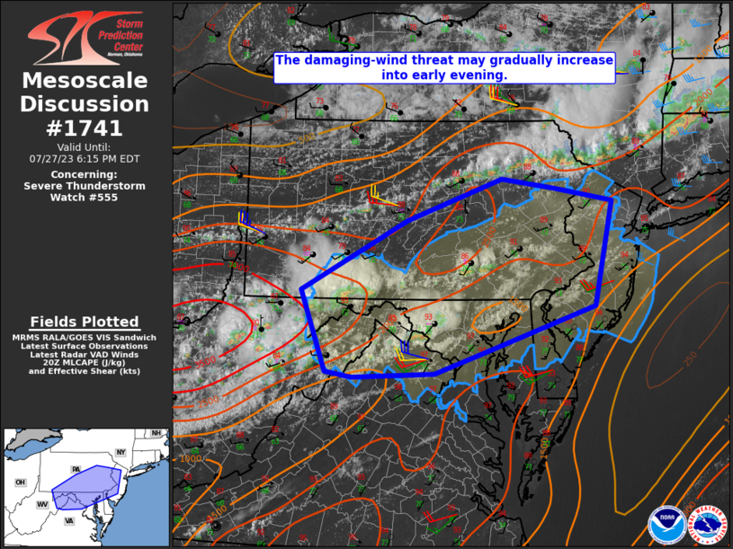
MD 1741 CONCERNING SEVERE POTENTIAL…WATCH POSSIBLE FOR PORTIONS OF SOUTHERN IOWA…NORTHERN MISSOURI…AND EXTREME WEST-CENTRAL ILLINOIS Mesoscale Discussion 1741 NWS Storm Prediction Center Norman OK 0847 AM CDT Tue Jul 30 2024 Areas affected…portions of southern Iowa…northern Missouri…and extreme west-central Illinois Concerning…Severe potential…Watch possible Valid 301347Z – 301515Z Probability of Watch Issuance…60 percent SUMMARY…Damaging gusts are …
Continue reading SPC MD 1741