

MD 1653 CONCERNING SEVERE POTENTIAL…WATCH POSSIBLE FOR EASTERN PENNSYLVANIA INTO NORTHERN MARYLAND…NEW JERSEY…AND FAR SOUTHERN NEW YORK Mesoscale Discussion 1653 NWS Storm Prediction Center Norman OK 0135 PM CDT Tue Jul 16 2024 Areas affected…Eastern Pennsylvania into Northern Maryland…New Jersey…and far Southern New York Concerning…Severe potential…Watch possible Valid 161835Z – 162030Z Probability of Watch Issuance…40 …
Continue reading SPC MD 1653
Category:Weather
SPC Severe Thunderstorm Watch 546 Status Reports

WW 0546 Status Updates STATUS REPORT ON WW 546 SEVERE WEATHER THREAT CONTINUES RIGHT OF A LINE FROM 35 NNE IPT TO 35 W ART. FOR ADDITIONAL INFORMATION SEE MESOSCALE DISCUSSION 1652 ..HALBERT..07/16/24 ATTN…WFO…BUF…BGM…CTP… STATUS REPORT FOR WS 546 SEVERE WEATHER THREAT CONTINUES FOR THE FOLLOWING AREAS NYC007-011-017-023-025-045-049-053-065-067-075-077-107-109- 161940- NY . NEW YORK COUNTIES INCLUDED …
Continue reading SPC Severe Thunderstorm Watch 546 Status Reports
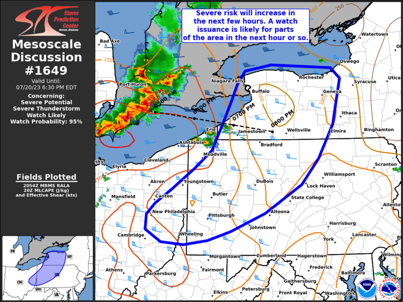
SPC MD 1652

MD 1652 CONCERNING SEVERE THUNDERSTORM WATCH 546… FOR WESTERN/CENTRAL NEW YORK INTO NORTHERN PENNSYLVANIA Mesoscale Discussion 1652 NWS Storm Prediction Center Norman OK 1227 PM CDT Tue Jul 16 2024 Areas affected…Western/central New York into Northern Pennsylvania Concerning…Severe Thunderstorm Watch 546… Valid 161727Z – 161900Z The severe weather threat for Severe Thunderstorm Watch 546 continues. …
Continue reading SPC MD 1652
SPC Severe Thunderstorm Watch 547
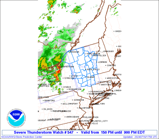
WW 547 SEVERE TSTM MA NY VT 161750Z – 170100Z URGENT – IMMEDIATE BROADCAST REQUESTED Severe Thunderstorm Watch Number 547 NWS Storm Prediction Center Norman OK 150 PM EDT Tue Jul 16 2024 The NWS Storm Prediction Center has issued a * Severe Thunderstorm Watch for portions of Western Massachusetts Eastern New York Central and …
Continue reading SPC Severe Thunderstorm Watch 547
SPC MD 1651

MD 1651 CONCERNING SEVERE POTENTIAL…WATCH POSSIBLE FOR SOUTHEAST MO INTO SOUTHWEST IL Mesoscale Discussion 1651 NWS Storm Prediction Center Norman OK 1202 PM CDT Tue Jul 16 2024 Areas affected…Southeast MO into southwest IL Concerning…Severe potential…Watch possible Valid 161702Z – 161830Z Probability of Watch Issuance…40 percent SUMMARY…Some damaging-wind threat could persist into this afternoon. DISCUSSION…A …
Continue reading SPC MD 1651
SPC Severe Thunderstorm Watch 545 Status Reports
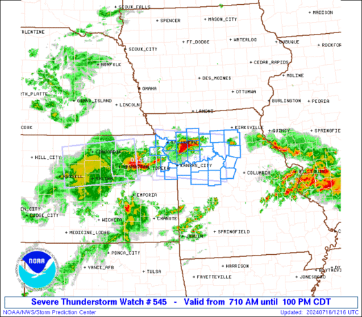
WW 0545 Status Updates STATUS REPORT ON WW 545 SEVERE WEATHER THREAT CONTINUES RIGHT OF A LINE FROM 15 SSW SZL TO 35 NNE SZL TO 30 NNW COU. ..DEAN..07/16/24 ATTN…WFO…EAX… STATUS REPORT FOR WS 545 SEVERE WEATHER THREAT CONTINUES FOR THE FOLLOWING AREAS MOC053-089-159-195-161740- MO . MISSOURI COUNTIES INCLUDED ARE COOPER HOWARD PETTIS SALINE …
Continue reading SPC Severe Thunderstorm Watch 545 Status Reports
SPC MD 1650

MD 1650 CONCERNING SEVERE POTENTIAL…WATCH LIKELY FOR WESTERN/CENTRAL NY INTO NORTHERN PA Mesoscale Discussion 1650 NWS Storm Prediction Center Norman OK 0933 AM CDT Tue Jul 16 2024 Areas affected…Western/central NY into northern PA Concerning…Severe potential…Watch likely Valid 161433Z – 161630Z Probability of Watch Issuance…80 percent SUMMARY…The severe-thunderstorm threat will increase through the morning, with …
Continue reading SPC MD 1650
SPC Severe Thunderstorm Watch 546
WW 546 SEVERE TSTM NY PA LE LO 161505Z – 162200Z URGENT – IMMEDIATE BROADCAST REQUESTED Severe Thunderstorm Watch Number 546 NWS Storm Prediction Center Norman OK 1105 AM EDT Tue Jul 16 2024 The NWS Storm Prediction Center has issued a * Severe Thunderstorm Watch for portions of Western and Central New York Northern …
Continue reading SPC Severe Thunderstorm Watch 546
SPC MD 1649
MD 1649 CONCERNING SEVERE THUNDERSTORM WATCH 545… FOR EXTREME NORTHEAST KS INTO PARTS OF MO AND SOUTHWEST IL Mesoscale Discussion 1649 NWS Storm Prediction Center Norman OK 0845 AM CDT Tue Jul 16 2024 Areas affected…Extreme northeast KS into parts of MO and southwest IL Concerning…Severe Thunderstorm Watch 545… Valid 161345Z – 161515Z The severe …
Continue reading SPC MD 1649
SPC Severe Thunderstorm Watch 544 Status Reports

WW 0544 Status Updates 161400- STATUS REPORT ON WW 544 SEVERE WEATHER THREAT CONTINUES RIGHT OF A LINE FROM 20 WNW EMP TO 15 WSW TOP. WW 544 WILL BE ALLOWED TO EXPIRE AT 161400Z. ..HALBERT..07/16/24 ATTN…WFO… STATUS REPORT FOR WS 544 SEVERE WEATHER THREAT CONTINUES FOR THE FOLLOWING AREAS KSC045-087-177-161400- KS . KANSAS COUNTIES …
Continue reading SPC Severe Thunderstorm Watch 544 Status Reports