

MD 1632 CONCERNING SEVERE POTENTIAL…WATCH UNLIKELY FOR SOUTHEAST PA INTO MD/DC/NORTHERN VA Mesoscale Discussion 1632 NWS Storm Prediction Center Norman OK 0241 PM CDT Mon Jul 15 2024 Areas affected…Southeast PA into MD/DC/northern VA Concerning…Severe potential…Watch unlikely Valid 151941Z – 152145Z Probability of Watch Issuance…20 percent SUMMARY…Isolated damaging wind is possible through late afternoon. DISCUSSION…Convection …
Continue reading SPC MD 1632
Category:Weather
SPC MD 1631

MD 1631 CONCERNING SEVERE POTENTIAL…WATCH UNLIKELY FOR PARTS OF CENTRAL/SOUTHEAST IN INTO SOUTHWEST/CENTRAL OH Mesoscale Discussion 1631 NWS Storm Prediction Center Norman OK 0218 PM CDT Mon Jul 15 2024 Areas affected…Parts of central/southeast IN into southwest/central OH Concerning…Severe potential…Watch unlikely Valid 151918Z – 152115Z Probability of Watch Issuance…20 percent SUMMARY…Isolated hail and damaging wind …
Continue reading SPC MD 1631
SPC MD 1630

MD 1630 CONCERNING SEVERE POTENTIAL…WATCH LIKELY FOR CENTRAL IOWA…SOUTHERN WISCONSIN…AND NORTHERN ILLINOIS Mesoscale Discussion 1630 NWS Storm Prediction Center Norman OK 0159 PM CDT Mon Jul 15 2024 Areas affected…Central Iowa…Southern Wisconsin…and Northern Illinois Concerning…Severe potential…Watch likely Valid 151859Z – 152130Z Probability of Watch Issuance…95 percent SUMMARY…A severe thunderstorm watch is likely later this afternoon …
Continue reading SPC MD 1630
SPC MD 1629

MD 1629 CONCERNING SEVERE POTENTIAL…WATCH UNLIKELY FOR SOUTHEAST NY/NORTHERN NJ INTO PARTS OF SOUTHERN NEW ENGLAND Mesoscale Discussion 1629 NWS Storm Prediction Center Norman OK 0114 PM CDT Mon Jul 15 2024 Areas affected…Southeast NY/northern NJ into parts of southern New England Concerning…Severe potential…Watch unlikely Valid 151814Z – 152015Z Probability of Watch Issuance…20 percent SUMMARY…Isolated …
Continue reading SPC MD 1629
SPC MD 1628

MD 1628 CONCERNING SEVERE POTENTIAL…WATCH POSSIBLE FOR PARTS OF WESTERN/CENTRAL NY/PA Mesoscale Discussion 1628 NWS Storm Prediction Center Norman OK 1052 AM CDT Mon Jul 15 2024 Areas affected…Parts of western/central NY/PA Concerning…Severe potential…Watch possible Valid 151552Z – 151745Z Probability of Watch Issuance…60 percent SUMMARY…The severe-thunderstorm threat is expected to increase with time this afternoon, …
Continue reading SPC MD 1628
SPC MD 1627

MD 1627 CONCERNING SEVERE THUNDERSTORM WATCH 536… FOR FAR SOUTHEAST NORTH DAKOTA…FAR NORTHEAST SOUTH DAKOTA…WESTERN AND SOUTHWESTERN MINNESOTA Mesoscale Discussion 1627 NWS Storm Prediction Center Norman OK 0437 AM CDT Mon Jul 15 2024 Areas affected…Far Southeast North Dakota…Far Northeast South Dakota…Western and Southwestern Minnesota Concerning…Severe Thunderstorm Watch 536… Valid 150937Z – 151130Z The severe …
Continue reading SPC MD 1627
SPC Severe Thunderstorm Watch 537 Status Reports
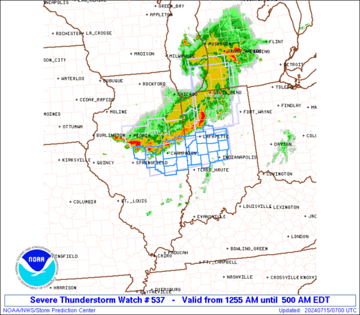
WW 0537 Status Updates STATUS REPORT ON WW 537 SEVERE WEATHER THREAT CONTINUES RIGHT OF A LINE FROM 10 ESE PIA TO 5 WSW CMI TO 25 S LAF TO 20 SE LAF TO 45 ENE LAF. ..BROYLES..07/15/24 ATTN…WFO…ILX…IND… STATUS REPORT FOR WS 537 SEVERE WEATHER THREAT CONTINUES FOR THE FOLLOWING AREAS ILC029-039-041-045-107-115-139-147-150940- IL . …
Continue reading SPC Severe Thunderstorm Watch 537 Status Reports
SPC Severe Thunderstorm Watch 536 Status Reports
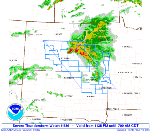
WW 0536 Status Updates STATUS REPORT ON WW 536 SEVERE WEATHER THREAT CONTINUES RIGHT OF A LINE FROM 25 NE MBG TO 45 S JMS TO 40 NE JMS. ..BROYLES..07/15/24 ATTN…WFO…ABR…FGF…BIS… STATUS REPORT FOR WS 536 SEVERE WEATHER THREAT CONTINUES FOR THE FOLLOWING AREAS MNC011-027-155-167-150940- MN . MINNESOTA COUNTIES INCLUDED ARE BIG STONE CLAY TRAVERSE …
Continue reading SPC Severe Thunderstorm Watch 536 Status Reports
SPC MD 1626

MD 1626 CONCERNING SEVERE THUNDERSTORM WATCH 536… FOR CENTRAL AND SOUTHEAST NORTH DAKOTA Mesoscale Discussion 1626 NWS Storm Prediction Center Norman OK 0236 AM CDT Mon Jul 15 2024 Areas affected…Central and Southeast North Dakota Concerning…Severe Thunderstorm Watch 536… Valid 150736Z – 150930Z The severe weather threat for Severe Thunderstorm Watch 536 continues. SUMMARY…A threat …
Continue reading SPC MD 1626
SPC Severe Thunderstorm Watch 535 Status Reports

WW 0535 Status Updates STATUS REPORT ON WW 535 SEVERE WEATHER THREAT CONTINUES RIGHT OF A LINE FROM 10 NW LAF TO 40 SSE SBN TO 30 S AZO TO 15 SE GRR. ..BROYLES..07/15/24 ATTN…WFO…IWX…GRR… STATUS REPORT FOR WS 535 SEVERE WEATHER THREAT CONTINUES FOR THE FOLLOWING AREAS INC017-069-085-103-113-169-181-183-150840- IN . INDIANA COUNTIES INCLUDED ARE …
Continue reading SPC Severe Thunderstorm Watch 535 Status Reports