

MD 1586 CONCERNING SEVERE POTENTIAL…WATCH UNLIKELY FOR THE NORTHERN/CENTRAL HIGH PLAINS Mesoscale Discussion 1586 NWS Storm Prediction Center Norman OK 0444 PM CDT Fri Jul 12 2024 Areas affected…the northern/central High Plains Concerning…Severe potential…Watch unlikely Valid 122144Z – 122315Z Probability of Watch Issuance…5 percent SUMMARY…Sporadic and highly localized severe wind gusts will be possible within …
Continue reading SPC MD 1586
Category:Weather
SPC MD 1585

MD 1585 CONCERNING SEVERE POTENTIAL…WATCH UNLIKELY FOR FAR NORTHEAST ARKANSAS INTO SOUTHERN ILLINOIS AND FAR SOUTHWEST INDIANA Mesoscale Discussion 1585 NWS Storm Prediction Center Norman OK 0440 PM CDT Fri Jul 12 2024 Areas affected…Far northeast Arkansas into southern Illinois and far southwest Indiana Concerning…Severe potential…Watch unlikely Valid 122140Z – 122315Z Probability of Watch Issuance…5 …
Continue reading SPC MD 1585
SPC MD 1584

MD 1584 CONCERNING SEVERE POTENTIAL…WATCH UNLIKELY FOR FAR NORTHEASTERN MONTANA…WESTERN NORTH DAKOTA…AND FAR NORTHWESTERN SOUTH DAKOTA Mesoscale Discussion 1584 NWS Storm Prediction Center Norman OK 0356 PM CDT Fri Jul 12 2024 Areas affected…Far northeastern Montana…western North Dakota…and far northwestern South Dakota Concerning…Severe potential…Watch unlikely Valid 122056Z – 122300Z Probability of Watch Issuance…20 percent SUMMARY…Widely …
Continue reading SPC MD 1584
SPC MD 1583

MD 1583 CONCERNING SEVERE POTENTIAL…WATCH UNLIKELY FOR SOUTHEAST KANSAS…SOUTHWEST MISSOURI…FAR NORTHEAST OKLAHOMA Mesoscale Discussion 1583 NWS Storm Prediction Center Norman OK 0138 AM CDT Fri Jul 12 2024 Areas affected…Southeast Kansas…Southwest Missouri…Far Northeast Oklahoma Concerning…Severe potential…Watch unlikely Valid 120638Z – 120845Z Probability of Watch Issuance…20 percent SUMMARY…A threat for isolated large hail will likely continue …
Continue reading SPC MD 1583
SPC MD 1582

MD 1582 CONCERNING SEVERE POTENTIAL…WATCH UNLIKELY FOR NORTHEAST KANSAS TO NORTHWEST MISSOURI Mesoscale Discussion 1582 NWS Storm Prediction Center Norman OK 1036 PM CDT Thu Jul 11 2024 Areas affected…Northeast Kansas to northwest Missouri Concerning…Severe potential…Watch unlikely Valid 120336Z – 120500Z Probability of Watch Issuance…5 percent SUMMARY…An isolated severe hail risk may persist across northwest …
Continue reading SPC MD 1582
SPC MD 1581

MD 1581 CONCERNING SEVERE POTENTIAL…WATCH UNLIKELY FOR PORTIONS OF THE CENTRAL HIGH PLAINS Mesoscale Discussion 1581 NWS Storm Prediction Center Norman OK 0522 PM CDT Thu Jul 11 2024 Areas affected…Portions of the central High Plains Concerning…Severe potential…Watch unlikely Valid 112222Z – 120015Z Probability of Watch Issuance…5 percent SUMMARY…Isolated to scattered thunderstorms developing across the …
Continue reading SPC MD 1581
SPC MD 1580

MD 1580 CONCERNING SEVERE POTENTIAL…WATCH UNLIKELY FOR SOUTHEASTERN KANSAS INTO SOUTHWEST MISSOURI Mesoscale Discussion 1580 NWS Storm Prediction Center Norman OK 0344 PM CDT Thu Jul 11 2024 Areas affected…Southeastern Kansas into southwest Missouri Concerning…Severe potential…Watch unlikely Valid 112044Z – 112245Z Probability of Watch Issuance…20 percent SUMMARY…Isolated large hail and severe gusts will be the …
Continue reading SPC MD 1580
SPC MD 1579

MD 1579 CONCERNING SEVERE POTENTIAL…WATCH POSSIBLE FOR SOUTHEASTERN ARIZONA AND ADJACENT SOUTHWESTERN NEW MEXICO Mesoscale Discussion 1579 NWS Storm Prediction Center Norman OK 0158 PM CDT Thu Jul 11 2024 Areas affected…southeastern Arizona and adjacent southwestern New Mexico Concerning…Severe potential…Watch possible Valid 111858Z – 112200Z Probability of Watch Issuance…40 percent SUMMARY…Thunderstorms developing across the higher …
Continue reading SPC MD 1579
SPC Tornado Watch 520 Status Reports
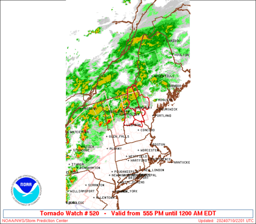
WW 0520 Status Updates STATUS REPORT ON WW 520 SEVERE WEATHER THREAT CONTINUES RIGHT OF A LINE FROM 15 NE MPV TO 35 E BML. ..LEITMAN..07/11/24 ATTN…WFO…GYX… STATUS REPORT FOR WT 520 SEVERE WEATHER THREAT CONTINUES FOR THE FOLLOWING AREAS MEC017-110340- ME . MAINE COUNTIES INCLUDED ARE OXFORD NHC001-003-009-110340- NH . NEW HAMPSHIRE COUNTIES INCLUDED …
Continue reading SPC Tornado Watch 520 Status Reports
SPC MD 1578

MD 1578 CONCERNING TORNADO WATCH 520… FOR PORTIONS OF NH AND WESTERN ME Mesoscale Discussion 1578 NWS Storm Prediction Center Norman OK 0829 PM CDT Wed Jul 10 2024 Areas affected…portions of NH and western ME Concerning…Tornado Watch 520… Valid 110129Z – 110300Z The severe weather threat for Tornado Watch 520 continues. SUMMARY…A severe storm …
Continue reading SPC MD 1578