

MD 1560 CONCERNING TORNADO WATCH 514… FOR PARTS OF NORTHEASTERN TEXAS…WESTERN LOUISIANA…SOUTHWESTERN ARKANSAS Mesoscale Discussion 1560 NWS Storm Prediction Center Norman OK 0248 PM CDT Mon Jul 08 2024 Areas affected…parts of northeastern Texas…western Louisiana…southwestern Arkansas Concerning…Tornado Watch 514… Valid 081948Z – 082145Z The severe weather threat for Tornado Watch 514 continues. SUMMARY…An area of …
Continue reading SPC MD 1560
Category:Weather
SPC MD 1559

MD 1559 CONCERNING SEVERE POTENTIAL…WATCH UNLIKELY FOR NORTH-CENTRAL NEW MEXICO Mesoscale Discussion 1559 NWS Storm Prediction Center Norman OK 0133 PM CDT Mon Jul 08 2024 Areas affected…North-central New Mexico Concerning…Severe potential…Watch unlikely Valid 081833Z – 082030Z Probability of Watch Issuance…5 percent SUMMARY…Isolated, marginally severe hail and strong/severe wind gusts are possible as storms develop …
Continue reading SPC MD 1559
SPC MD 1558

MD 1558 CONCERNING TORNADO WATCH 514… FOR PARTS OF SOUTHEASTERN TEXAS AND SOUTHWESTERN/WEST CENTRAL LOUISIANA Mesoscale Discussion 1558 NWS Storm Prediction Center Norman OK 1119 AM CDT Mon Jul 08 2024 Areas affected…parts of southeastern Texas and southwestern/west central Louisiana Concerning…Tornado Watch 514… Valid 081619Z – 081815Z The severe weather threat for Tornado Watch 514 …
Continue reading SPC MD 1558
SPC MD 1557

MD 1557 CONCERNING TORNADO WATCH 513… FOR SOUTHEAST TEXAS AND SOUTHWEST LOUISIANA Mesoscale Discussion 1557 NWS Storm Prediction Center Norman OK 0753 AM CDT Mon Jul 08 2024 Areas affected…southeast Texas and southwest Louisiana Concerning…Tornado Watch 513… Valid 081253Z – 081500Z The severe weather threat for Tornado Watch 513 continues. SUMMARY…The tornado threat with Beryl …
Continue reading SPC MD 1557
SPC Tornado Watch 513 Status Reports
WW 0513 Status Updates STATUS REPORT ON WW 513 SEVERE WEATHER THREAT CONTINUES RIGHT OF A LINE FROM 50 SE PSX TO 35 S LBX TO 20 WNW LBX TO 45 S CLL. ..BENTLEY..07/08/24 ATTN…WFO…HGX…LCH… STATUS REPORT FOR WT 513 SEVERE WEATHER THREAT CONTINUES FOR THE FOLLOWING AREAS TXC039-071-157-167-199-201-245-291-339-081340- TX . TEXAS COUNTIES INCLUDED ARE …
Continue reading SPC Tornado Watch 513 Status Reports
SPC MD 1556

MD 1556 CONCERNING SEVERE POTENTIAL…WATCH UNLIKELY FOR EASTERN NEW MEXICO INTO THE WESTERN TEXAS PANHANDLE Mesoscale Discussion 1556 NWS Storm Prediction Center Norman OK 0438 AM CDT Mon Jul 08 2024 Areas affected…eastern New Mexico into the western Texas Panhandle Concerning…Severe potential…Watch unlikely Valid 080938Z – 081115Z Probability of Watch Issuance…20 percent SUMMARY…Several supercells have …
Continue reading SPC MD 1556
SPC MD 1555

MD 1555 CONCERNING TORNADO WATCH 513… FOR THE TEXAS COAST NEAR GALVESTON ISLAND Mesoscale Discussion 1555 NWS Storm Prediction Center Norman OK 0222 AM CDT Mon Jul 08 2024 Areas affected…The Texas Coast near Galveston Island Concerning…Tornado Watch 513… Valid 080722Z – 080915Z The severe weather threat for Tornado Watch 513 continues. SUMMARY…The greatest tornado …
Continue reading SPC MD 1555
SPC MD 1554

MD 1554 CONCERNING SEVERE POTENTIAL…WATCH POSSIBLE FOR UPPER TEXAS COAST Mesoscale Discussion 1554 NWS Storm Prediction Center Norman OK 1027 PM CDT Sun Jul 07 2024 Areas affected…Upper Texas Coast Concerning…Severe potential…Watch possible Valid 080327Z – 080600Z Probability of Watch Issuance…60 percent SUMMARY…Tornado threat is expected to increase across the upper Texas Coast later tonight …
Continue reading SPC MD 1554
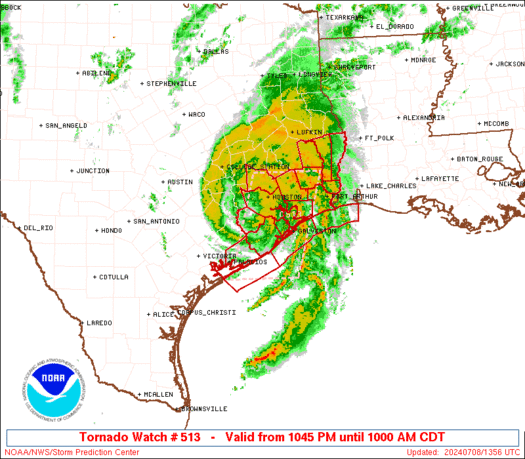
SPC Tornado Watch 513
WW 513 TORNADO TX CW 080345Z – 081500Z URGENT – IMMEDIATE BROADCAST REQUESTED Tornado Watch Number 513 NWS Storm Prediction Center Norman OK 1045 PM CDT Sun Jul 7 2024 The NWS Storm Prediction Center has issued a * Tornado Watch for portions of Upper Texas Coast Coastal Waters * Effective this Sunday night and …
Continue reading SPC Tornado Watch 513
SPC Severe Thunderstorm Watch 511 Status Reports

WW 0511 Status Updates STATUS REPORT ON WW 511 SEVERE WEATHER THREAT CONTINUES RIGHT OF A LINE FROM 45 W PUB TO 45 NE LAA TO 40 SSE GLD. FOR ADDITIONAL INFORMATION SEE MESOSCALE DISCUSSION ..THORNTON..07/08/24 ATTN…WFO…BOU…PUB…GLD…ABQ… STATUS REPORT FOR WS 511 SEVERE WEATHER THREAT CONTINUES FOR THE FOLLOWING AREAS COC009-011-055-071-089-099-101-080340- CO . COLORADO COUNTIES …
Continue reading SPC Severe Thunderstorm Watch 511 Status Reports