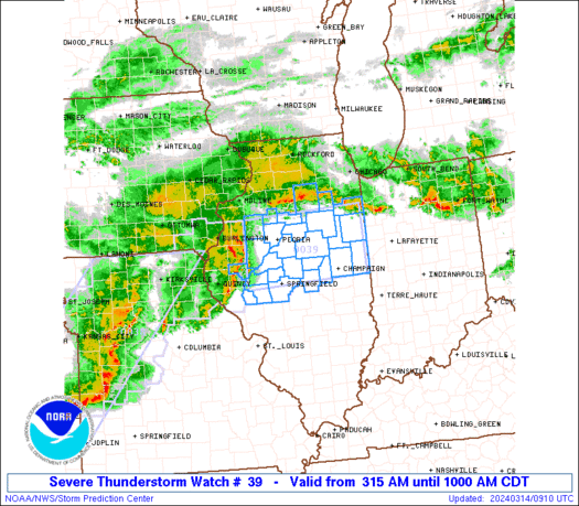
WW 39 SEVERE TSTM WI 150305Z – 150900Z URGENT – IMMEDIATE BROADCAST REQUESTED Severe Thunderstorm Watch Number 39 NWS Storm Prediction Center Norman OK 1005 PM CDT Fri Mar 14 2025 The NWS Storm Prediction Center has issued a * Severe Thunderstorm Watch for portions of Southern Wisconsin * Effective this Friday night and Saturday …
Continue reading SPC Severe Thunderstorm Watch 39
Category:Weather
SPC Tornado Watch 38
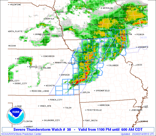
WW 38 TORNADO AR LA MS 150245Z – 151000Z URGENT – IMMEDIATE BROADCAST REQUESTED Tornado Watch Number 38 NWS Storm Prediction Center Norman OK 945 PM CDT Fri Mar 14 2025 The NWS Storm Prediction Center has issued a * Tornado Watch for portions of Southern Arkansas Northeast Louisiana Western Mississippi * Effective this Friday …
Continue reading SPC Tornado Watch 38
SPC Severe Thunderstorm Watch 35 Status Reports
WW 0035 Status Updates STATUS REPORT ON WW 35 THE SEVERE WEATHER THREAT CONTINUES ACROSS THE ENTIRE WATCH AREA. ..GOSS..03/15/25 ATTN…WFO…DVN…LOT… STATUS REPORT FOR WS 35 SEVERE WEATHER THREAT CONTINUES FOR THE FOLLOWING AREAS ILC007-011-015-031-037-043-063-067-071-073-085-089-091-093-097- 099-103-109-111-131-141-155-161-177-187-195-197-201-150240- IL . ILLINOIS COUNTIES INCLUDED ARE BOONE BUREAU CARROLL COOK DE KALB DUPAGE GRUNDY HANCOCK HENDERSON HENRY JO DAVIESS …
Continue reading SPC Severe Thunderstorm Watch 35 Status Reports
SPC Severe Thunderstorm Watch 34 Status Reports
WW 0034 Status Updates STATUS REPORT ON WW 34 SEVERE WEATHER THREAT CONTINUES RIGHT OF A LINE FROM 30 SSW MCW TO 35 W MCW TO 35 NE OTG. ..GOSS..03/15/25 ATTN…WFO…ARX…FSD…DMX…MPX… STATUS REPORT FOR WS 34 SEVERE WEATHER THREAT CONTINUES FOR THE FOLLOWING AREAS IAC005-033-037-043-065-067-081-089-131-189-191-195-150240- IA . IOWA COUNTIES INCLUDED ARE ALLAMAKEE CERRO GORDO CHICKASAW …
Continue reading SPC Severe Thunderstorm Watch 34 Status Reports
SPC Tornado Watch 37
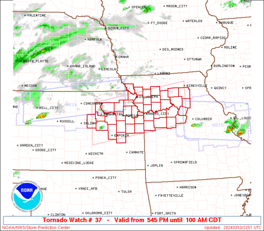
WW 37 TORNADO IL IN 150100Z – 150800Z URGENT – IMMEDIATE BROADCAST REQUESTED Tornado Watch Number 37 NWS Storm Prediction Center Norman OK 800 PM CDT Fri Mar 14 2025 The NWS Storm Prediction Center has issued a * Tornado Watch for portions of Central Illinois West-Central Indiana * Effective this Friday night and Saturday …
Continue reading SPC Tornado Watch 37
SPC Tornado Watch 36 Status Reports
WW 0036 Status Updates STATUS FOR WATCH 0036 HAS NOT BEEN ISSUED YET Read more Read More
SPC PDS Tornado Watch 36
WW 36 TORNADO AR IL IN KY MO MS TN 150030Z – 150800Z URGENT – IMMEDIATE BROADCAST REQUESTED Tornado Watch Number 36 NWS Storm Prediction Center Norman OK 730 PM CDT Fri Mar 14 2025 The NWS Storm Prediction Center has issued a * Tornado Watch for portions of Northeast Arkansas Southern Illinois Far Southwest …
Continue reading SPC PDS Tornado Watch 36
SPC Severe Thunderstorm Watch 31
WW 31 SEVERE TSTM IA NE 142020Z – 150300Z URGENT – IMMEDIATE BROADCAST REQUESTED Severe Thunderstorm Watch Number 31 NWS Storm Prediction Center Norman OK 320 PM CDT Fri Mar 14 2025 The NWS Storm Prediction Center has issued a * Severe Thunderstorm Watch for portions of Western and Central Iowa Eastern Nebraska * Effective …
Continue reading SPC Severe Thunderstorm Watch 31
SPC Severe Thunderstorm Watch 31 Status Reports
WW 0031 Status Updates STATUS REPORT ON WW 31 SEVERE WEATHER THREAT CONTINUES RIGHT OF A LINE FROM 10 SW LWD TO 25 E SDA TO 15 S OMA TO 25 S OLU. ..LYONS..03/14/25 ATTN…WFO…DMX…OAX… STATUS REPORT FOR WS 31 SEVERE WEATHER THREAT CONTINUES FOR THE FOLLOWING AREAS IAC001-003-007-009-013-015-017-023-025-027-029-039-047-049-051- 053-069-073-075-077-079-083-085-091-099-117-121-123-125-127-133- 135-151-153-155-157-159-161-165-169-171-173-175-179-181-185-187- 197-142340- IA . IOWA …
Continue reading SPC Severe Thunderstorm Watch 31 Status Reports
SPC Tornado Watch 32 Status Reports
WW 0032 Status Updates STATUS REPORT ON WW 32 THE SEVERE WEATHER THREAT CONTINUES ACROSS THE ENTIRE WATCH AREA. ..LYONS..03/14/25 ATTN…WFO…LZK…TSA…LSX…EAX…SGF… STATUS REPORT FOR WT 32 SEVERE WEATHER THREAT CONTINUES FOR THE FOLLOWING AREAS ARC005-009-015-023-029-045-047-049-063-065-071-083-087-089-101- 115-129-135-137-141-145-142340- AR . ARKANSAS COUNTIES INCLUDED ARE BAXTER BOONE CARROLL CLEBURNE CONWAY FAULKNER FRANKLIN FULTON INDEPENDENCE IZARD JOHNSON LOGAN MADISON …
Continue reading SPC Tornado Watch 32 Status Reports

