

MD 0082 CONCERNING HEAVY SNOW FOR PARTS OF THE MID-ATLANTIC Mesoscale Discussion 0082 NWS Storm Prediction Center Norman OK 0149 PM CST Tue Feb 11 2025 Areas affected…parts of the Mid-Atlantic Concerning…Heavy snow Valid 111949Z – 112345Z SUMMARY…A band of heavy snow developing across the Mid-Atlantic region will be capable of moderate to heavy snowfall …
Continue reading SPC MD 82
Category:Weather
SPC MD 81

MD 0081 CONCERNING FREEZING RAIN FOR FAR NORTHWEST NORTH CAROLINA…EASTERN WEST VIRGINIA…AND WESTERN TO CENTRAL VIRGINIA Mesoscale Discussion 0081 NWS Storm Prediction Center Norman OK 1126 AM CST Tue Feb 11 2025 Areas affected…Far northwest North Carolina…eastern West Virginia…and western to central Virginia Concerning…Freezing rain Valid 111726Z – 112230Z SUMMARY…Freezing rain is expected to become …
Continue reading SPC MD 81
SPC MD 80

MD 0080 CONCERNING HEAVY SNOW FOR CENTRAL AND EASTERN KENTUCKY/WESTERN VIRGINIA/SOUTHERN WEST VIRGINIA Mesoscale Discussion 0080 NWS Storm Prediction Center Norman OK 0306 AM CST Tue Feb 11 2025 Areas affected…Central and Eastern Kentucky/Western Virginia/Southern West Virginia Concerning…Heavy snow Valid 110906Z – 111500Z SUMMARY…A band of snow will continue to develop across the Ohio Valley …
Continue reading SPC MD 80
SPC MD 79

MD 0079 CONCERNING HEAVY SNOW FOR PARTS OF NEW ENGLAND AND EASTERN NY Mesoscale Discussion 0079 NWS Storm Prediction Center Norman OK 0901 PM CST Sat Feb 08 2025 Areas affected…parts of New England and eastern NY Concerning…Heavy snow Valid 090301Z – 090700Z SUMMARY…Multiple bands of heavy snow with rates of 1-2 inches per hour …
Continue reading SPC MD 79
SPC MD 78
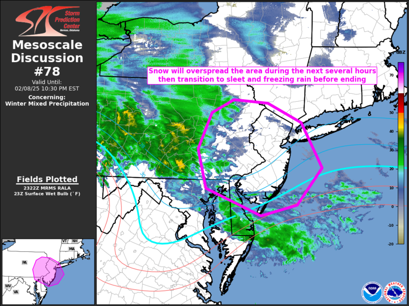
MD 0078 CONCERNING WINTER MIXED PRECIPITATION FOR FAR NORTHERN PORTIONS OF THE MID-ATLANTIC AND FAR SOUTHERN PORTIONS OF NEW ENGLAND Mesoscale Discussion 0078 NWS Storm Prediction Center Norman OK 0524 PM CST Sat Feb 08 2025 Areas affected…far northern portions of the Mid-Atlantic and far southern portions of New England Concerning…Winter mixed precipitation Valid 082324Z …
Continue reading SPC MD 78
SPC MD 77

MD 0077 CONCERNING HEAVY SNOW FOR PARTS OF THE NORTHEAST AND SOUTHERN NEW ENGLAND Mesoscale Discussion 0077 NWS Storm Prediction Center Norman OK 0521 PM CST Sat Feb 08 2025 Areas affected…parts of the Northeast and southern New England Concerning…Heavy snow Valid 082321Z – 090315Z SUMMARY…Leading corridor of winter storm across the Northeast will produce …
Continue reading SPC MD 77
SPC MD 76

MD 0076 CONCERNING WINTER MIXED PRECIPITATION FOR NORTHWEST TO SOUTH-CENTRAL PENNSYLVANIA INTO FAR NORTHERN WEST-VIRGINIA/MARYLAND Mesoscale Discussion 0076 NWS Storm Prediction Center Norman OK 0242 PM CST Sat Feb 08 2025 Areas affected…northwest to south-central Pennsylvania into far northern West-Virginia/Maryland Concerning…Winter mixed precipitation Valid 082042Z – 090045Z SUMMARY…Snow transitioning to a combination of sleet and …
Continue reading SPC MD 76
SPC MD 75

MD 0075 CONCERNING FREEZING RAIN FOR NORTHEAST INDIANA INTO FAR SOUTHERN MICHIGAN AND NORTHERN OHIO Mesoscale Discussion 0075 NWS Storm Prediction Center Norman OK 1146 AM CST Sat Feb 08 2025 Areas affected…Northeast Indiana into far southern Michigan and northern Ohio Concerning…Freezing rain Valid 081746Z – 082245Z SUMMARY…Freezing rain will gradually become more widespread across …
Continue reading SPC MD 75
SPC MD 74

MD 0074 CONCERNING HEAVY SNOW FOR SOUTHERN ND VICINITY Mesoscale Discussion 0074 NWS Storm Prediction Center Norman OK 0514 PM CST Fri Feb 07 2025 Areas affected…southern ND vicinity Concerning…Heavy snow Valid 072314Z – 080315Z SUMMARY…Narrow, transient bands of heavy snowfall rates around 1 inch per hour should persist through the mid-evening hours across the …
Continue reading SPC MD 74
SPC MD 73

MD 0073 CONCERNING SEVERE THUNDERSTORM WATCH 4… FOR PORTIONS OF EASTERN TENNESSEE…KENTUCKY…AND FAR WESTERN VIRGINIA Mesoscale Discussion 0073 NWS Storm Prediction Center Norman OK 0828 PM CST Thu Feb 06 2025 Areas affected…Portions of eastern Tennessee…Kentucky…and far western Virginia Concerning…Severe Thunderstorm Watch 4… Valid 070228Z – 070330Z The severe weather threat for Severe Thunderstorm Watch …
Continue reading SPC MD 73