
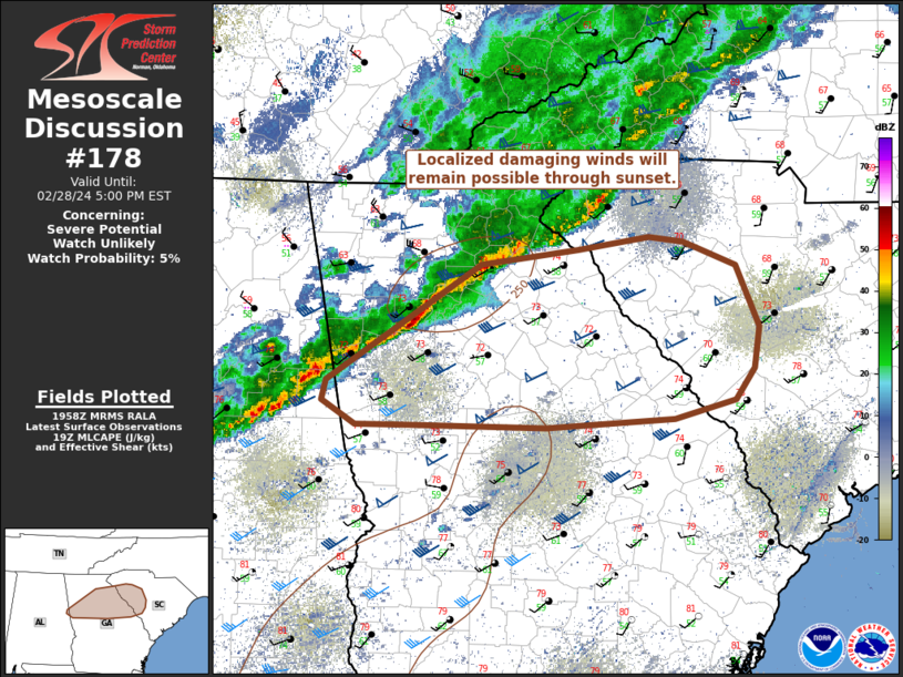
MD 0178 CONCERNING SEVERE POTENTIAL…WATCH UNLIKELY FOR NORTH GA INTO WESTERN SC
Mesoscale Discussion 0178
NWS Storm Prediction Center Norman OK
0159 PM CST Wed Feb 28 2024
Areas affected…North GA into western SC
Concerning…Severe potential…Watch unlikely
Valid 281959Z – 282200Z
Probability of Watch Issuance…5 percent
SUMMARY…Localized damaging winds will remain possible through the
rest of the afternoon as a low-topped squall line moves east across
north Georgia into western South Carolina.
DISCUSSION…Lightning production within a long-lived but thin
squall line has become confined to parts of north GA into
east-central AL, where echo tops remain below 30k ft. A brief uptick
in intensity was noted into northwest GA where 35-45 kt measured
gusts and subsequent reports of nearby tree damage occurred, as the
line has approached the greater Atlanta Metro Area. Scant buoyancy
with MLCAPE below 200 J/kg remains the limiting factor to a more
prominent severe threat. Still, with surface temperatures in the mid
70s ahead of the squall into the Savannah Valley, sporadic strong
gusts from 45 to 60 mph will remain possible through sunset.
..Grams/Guyer.. 02/28/2024
…Please see www.spc.noaa.gov for graphic product…
ATTN…WFO…CAE…GSP…FFC…BMX…
LAT…LON 34358391 34478298 34578230 34538197 34348147 33858125
33518130 33278149 33118206 33048329 33068467 33078510
33268542 33418538 34358391