
MD 2051 CONCERNING SEVERE THUNDERSTORM WATCH 658… FOR EASTERN ILLINOIS…SOUTHWEST INDIANA
Mesoscale Discussion 2051
NWS Storm Prediction Center Norman OK
1016 PM CDT Fri Aug 25 2023
Areas affected…Eastern Illinois…Southwest Indiana
Concerning…Severe Thunderstorm Watch 658…
Valid 260316Z – 260515Z
The severe weather threat for Severe Thunderstorm Watch 658
continues.
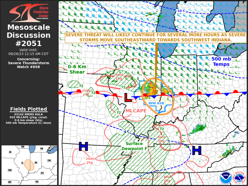
SUMMARY…A severe threat is expected to continue across southeast
Illinois and southwest Indiana. Large hail and wind damage will be
the primary threats. A watch extension has been locally extended
into more of southwest Indiana.
DISCUSSION…The latest high-resolution radar imagery from Lincoln,
Illinois show a short bowing line of severe storms over eastern
Illinois. Recently, wind gusts of over 40 knots have been observed
at Decatur, Mattoon, and Champaign, Illinois. This line is located
near a quasi-stationary front extending eastward across
south-central Illinois and south-central Indiana. Near this front,
strong instability is present with the RAP showing MLCAPE in the
3500 to 4500 J/kg range. The linear convective system is moving near
40 knots to the east-southeast. This, along with steep low-level
lapse rates evident on forecast soundings, will be favorable for a
wind-damage threat over the next few hours. The greatest wind-damage
potential will likely exist along the path of the bow’s apex. Gusts
in excess of 60 knots, and isolated large hail will likely accompany
the most intense parts of this convective line.
..Broyles.. 08/26/2023
…Please see www.spc.noaa.gov for graphic product…
ATTN…WFO…LMK…IND…PAH…LOT…ILX…
LAT…LON 38358755 38448700 38738671 39298663 39838695 40368766
40408832 40158874 39608892 39078874 38438791 38358755