
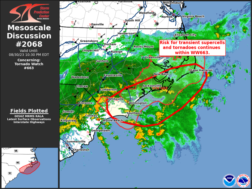
MD 2068 CONCERNING TORNADO WATCH 663… FOR COASTAL NORTH CAROLINA AND OUTER BANKS
Mesoscale Discussion 2068
NWS Storm Prediction Center Norman OK
0759 PM CDT Wed Aug 30 2023
Areas affected…Coastal North Carolina and Outer Banks
Concerning…Tornado Watch 663…
Valid 310059Z – 310230Z
The severe weather threat for Tornado Watch 663 continues.
SUMMARY…Risk for transient supercells and a few tornadoes
continues within WW663.
DISCUSSION…Latest radar trends continue to show transient
supercells within the near-shore regions of coastal North Carolina
from Cape Fear northward to the Outer Banks. Recent 00z RAOB from
MHX indicates deeply saturated profile with MLCAPE around 500 J/kg
and generally weak low-level shear. The VAD profile from KMHX has
shown slow improvement in low-level shear with increasing curvature
in the hodograph and 0-3 km SRH around 200 m2/s2. Inland
temperatures have cooled as persistent banded rainfall continues to
move inland. Within the next few hours, the greatest tornado threat
is expected to be focus mainly along the immediate coast line
shifting northward toward the Outer Banks and adjacent coastal
waters where the best overlap of MLCAPE around 500-1000 J/kg
overlaps deep layer shear around 40 kts.
..Thornton/Grams.. 08/31/2023
…Please see www.spc.noaa.gov for graphic product…
ATTN…WFO…MHX…RAH…ILM…
LAT…LON 33657685 33597736 33667790 33737818 33857851 33957862
34097871 34377872 34557841 34747807 34817780 35007730
35147689 35327640 35417595 35477547 35387529 35257509
35047506 34707530 34417564 34147598 33657685