
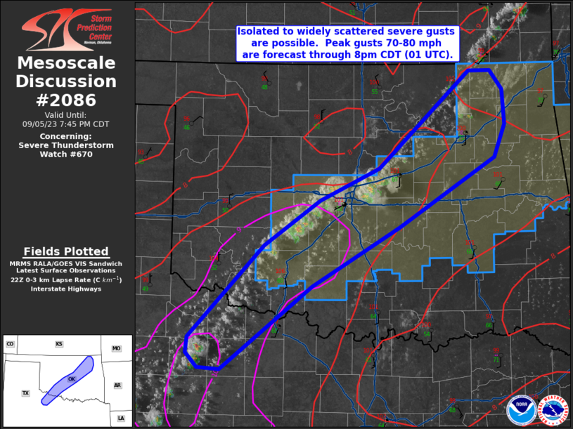
MD 2086 CONCERNING SEVERE THUNDERSTORM WATCH 670… FOR NORTHEAST INTO CENTRAL AND SOUTHWEST OK…NORTHWEST PART OF NORTH TX
Mesoscale Discussion 2086
NWS Storm Prediction Center Norman OK
0547 PM CDT Tue Sep 05 2023
Areas affected…northeast into central and southwest OK…northwest
part of north TX
Concerning…Severe Thunderstorm Watch 670…
Valid 052247Z – 060045Z
The severe weather threat for Severe Thunderstorm Watch 670
continues.
SUMMARY…Isolated to widely scattered severe gusts are possible
this evening. Peak gusts 70-80 mph are forecast through 8pm CDT (01
UTC).
DISCUSSION…Visible-satellite and lightning data shows developing
thunderstorms near and immediately north of the I-44 corridor from
northeast OK through central OK and into adjacent parts of southwest
OK/northwest part of north TX. Surface analysis shows a
southward-moving front where the developing thunderstorms are
located. Hot temperatures are noted, with in the lower 100s from TX
northeastward into central OK and upper 90s in a more moisture-rich
airmass over northeast OK. A plume of very steep 0-3 km lapse rates
(9+ deg C/km) has developed from northwest TX into central OK and PW
increases from west to east across the discussion area (1.4 to 1.8
inches). The inverted-v profiles strongly favor severe downdrafts
once mature thunderstorm cores develop. Strong evaporative cooling
will be the primary process for severe gusts from north TX into
central OK. Model guidance indicates greater storm coverage (a
broken band of storms) will eventually evolve this evening across
northeast OK and move into eastern OK and northwest AR. The risk
for severe gusts will likely persist with this activity while the
risk over central OK southwestward diminishes towards the late
evening.
..Smith.. 09/05/2023
…Please see www.spc.noaa.gov for graphic product…
ATTN…WFO…TSA…OUN…
LAT…LON 36929582 36929552 36699535 36309533 35929547 35129682
34449804 33489931 33499962 33679978 33849975 34909870
35439793 35809709 36929582