
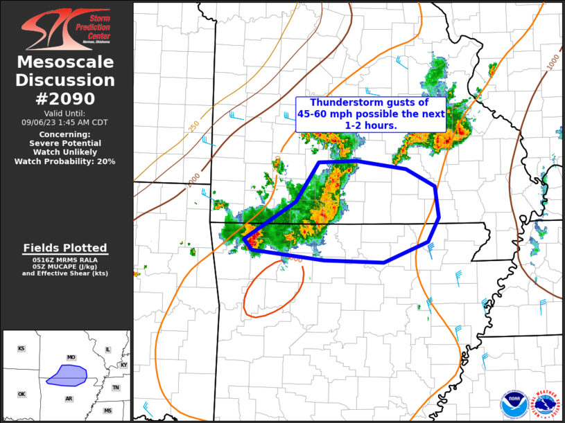
MD 2090 CONCERNING SEVERE POTENTIAL…WATCH UNLIKELY FOR SOUTH-CENTRAL MO INTO NORTHERN AR
Mesoscale Discussion 2090
NWS Storm Prediction Center Norman OK
1218 AM CDT Wed Sep 06 2023
Areas affected…south-central MO into northern AR
Concerning…Severe potential…Watch unlikely
Valid 060518Z – 060645Z
Probability of Watch Issuance…20 percent
SUMMARY…Sporadic strong thunderstorm gusts of 45-60 mph are
possible the next couple of hours.
DISCUSSION…A semi-organized bowing cluster of storms will continue
to develop eastward near the MO/AR border the next couple of hours.
This activity has shown some modest increase in organization and
intensity over the past 30-60 minutes, with a measured gust to 51 kt
recently noted at KVBT. Convection will continue to move through an
area of MUCAPE around 2000 J/kg and midlevel lapse rates around
7-7.5 C/km. This will likely maintain short-term storm intensity.
However, vertical shear remains fairly weak, with effective shear
around 20-25 kt. Furthermore, this activity will remain on the
southern fringes of a moderate low-level jet. As a result,
convection may produce sporadic gusts approaching severe limits in
the short term, but a gradual weakening trend is expected with
eastward extent over the next couple of hours, precluding the need
for a severe thunderstorm watch.
..Leitman/Edwards.. 09/06/2023
…Please see www.spc.noaa.gov for graphic product…
ATTN…WFO…PAH…LZK…SGF…TSA…
LAT…LON 35999179 36029275 36159392 36299406 36799322 37319285
37339223 37219141 36989095 36579089 36269107 35999179