
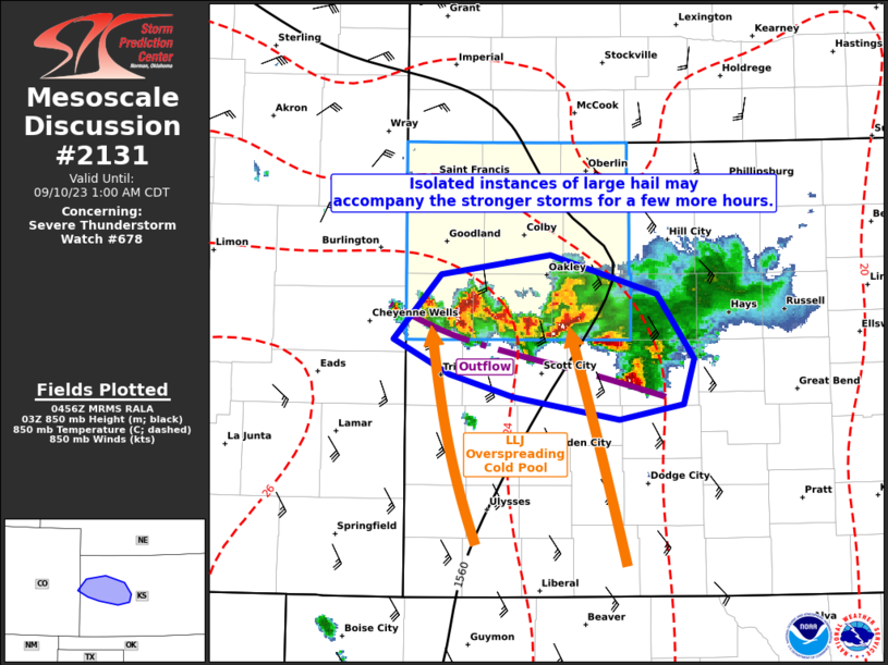
MD 2131 CONCERNING SEVERE THUNDERSTORM WATCH 678… FOR PORTIONS OF WESTERN KANSAS
Mesoscale Discussion 2131
NWS Storm Prediction Center Norman OK
1158 PM CDT Sat Sep 09 2023
Areas affected…portions of western Kansas
Concerning…Severe Thunderstorm Watch 678…
Valid 100458Z – 100600Z
The severe weather threat for Severe Thunderstorm Watch 678
continues.
SUMMARY…An isolated severe threat may continue for a few more
hours, with large hail becoming the main hazard.
DISCUSSION…Modest 850 mb warm-air advection associated with an
increasing low-level jet is over convective outflow and is
supporting the continued percolation of strong thunderstorm
updrafts. Given steep lapse rates atop a stabilizing boundary layer,
isolated bouts of large hail may accompany the stronger storm cores
for at least a couple of hours. While severe winds have been
observed with a supercell embedded on the leading line of convective
outflow, this storm is showing some weakening trends. With the
aforementioned elevated updrafts becoming farther displaced within
the remnant cold pool, suggesting that hail should be the dominant
severe hazard.
..Squitieri.. 09/10/2023
…Please see www.spc.noaa.gov for graphic product…
ATTN…WFO…DDC…GLD…
LAT…LON 38690214 39120174 39260082 38999992 38569962 38279970
38170025 38310114 38470167 38690214