
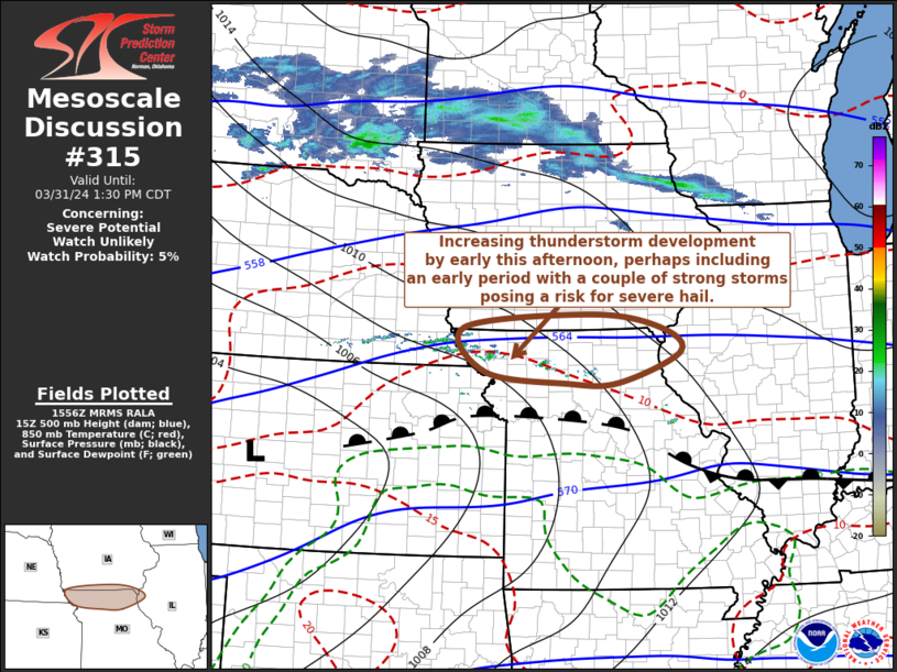
MD 0315 CONCERNING SEVERE POTENTIAL…WATCH UNLIKELY FOR NORTHERN MISSOURI AND ADJACENT PORTIONS OF SOUTHERN IOWA/NORTHWESTERN ILLINOIS
Mesoscale Discussion 0315
NWS Storm Prediction Center Norman OK
1058 AM CDT Sun Mar 31 2024
Areas affected…northern Missouri and adjacent portions of southern
Iowa/northwestern Illinois
Concerning…Severe potential…Watch unlikely
Valid 311558Z – 311830Z
Probability of Watch Issuance…5 percent
SUMMARY…An initial period of increasing thunderstorm development
appears likely across parts of northern Missouri into southeastern
Iowa and and northwestern Illinois his afternoon. This may include
strong thunderstorms posing a risk of severe hail for an hour or two
early this afternoon across parts of northwestern Missouri, before a
broader area of generally weaker thunderstorms evolves while
spreading northeastward.
DISCUSSION…Deepening convective development is evident within a
narrow corridor, roughly west-northwest of the St. Joseph through
Chillicothe MO vicinity. This is rooted above a near-surface
inversion layer, along/above a strengthening frontal zone, aided by
ascent supported by weak to modest low-level warm advection.
Beneath anticyclonic flow within the crest of broad mid/upper
ridging east of the southern Rockies into the Appalachians,
mid/upper support for convection, if any, appears subtle. However,
latest model output indicates increasing probabilities for
thunderstorm initiation west-northwest through north of the
Chillicothe vicinity by 17-18Z, where/when forecast soundings
indicate modest conditional and convective instability in the
presence of strong convective layer shear.
This environment may be conducive to the evolution of an initial
supercell structure of two, which may pose a risk for severe hail.
Thereafter, guidance suggests warmer and more strongly capping
elevated mixed-layer air will tend to gradually spread across and
north of the surface warm frontal zone. As this occurs, the warm
advection driven convection, while perhaps becoming more widespread,
may tend to become increasingly displaced to the north of the better
instability near and south of the frontal zonal, resulting in
diminishing risk for severe hail.
..Kerr/Thompson.. 03/31/2024
…Please see www.spc.noaa.gov for graphic product…
ATTN…WFO…LSX…DVN…DMX…EAX…OAX…
LAT…LON 39909505 40619549 40839287 40629147 40239104 39749232
39739339 39909505