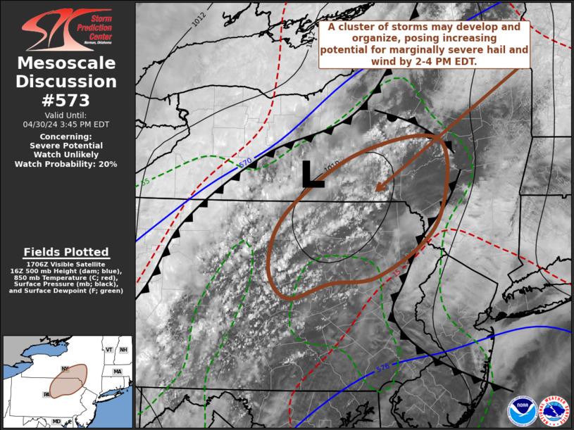
MD 0573 CONCERNING SEVERE POTENTIAL…WATCH UNLIKELY FOR PARTS OF SOUTH CENTRAL NEW YORK…NORTHEASTERN PENNSYLVANIA
Mesoscale Discussion 0573
NWS Storm Prediction Center Norman OK
1212 PM CDT Tue Apr 30 2024
Areas affected…parts of south central New York…northeastern
Pennsylvania
Concerning…Severe potential…Watch unlikely
Valid 301712Z – 301945Z
Probability of Watch Issuance…20 percent
SUMMARY…Intensifying thunderstorms, possibly including a gradually
organizing cluster, may pose increasing potential for marginally
severe hail and wind by 2-4 PM EDT. It is still not clear that a
severe weather watch will be needed, but trends will continue to be
monitored.
DISCUSSION…Downstream of remnant mid-level troughing crossing the
lower Great Lakes region, modest destabilization is underway across
eastern portions of the Allegheny Plateau in response to insolation.
This is leading to deepening boundary layer-based convection ahead
of a weak cold front now advancing southeast of Lakes Ontario and
Erie, and through the upper Ohio Valley.
Models suggest that large-scale forcing for ascent will contribute
to intensifying thunderstorm development by the 18-20Z time frame,
with orographic forcing perhaps contributing to a consolidating
cluster of convection across the southern tier of New York and
adjacent northern Pennsylvania. Thereafter, given increasing inflow
of sufficiently moist boundary-layer air to support CAPE in excess
of 500 J/kg, a belt of 30-40+ kt southwesterly flow in the 700-500
mb layer may contribute to a period of increasing organization and
potential for strong to marginally severe surface gusts, as activity
propagates toward the Catskills and Poconos vicinity. With
east-southeasterly low-level flow maintaining a relatively cool and
stable boundary-layer across the northern Mid Atlantic into the the
Poconos and Catskills, it appears that the potential for damaging
wind gusts will rapidly diminish to the east of the higher terrain
later this afternoon.
..Kerr/Hart.. 04/30/2024
…Please see www.spc.noaa.gov for graphic product…
ATTN…WFO…BGM…CTP…
LAT…LON 41847727 42567612 42737478 41757482 41117574 41017655
40837723 41197754 41847727
