
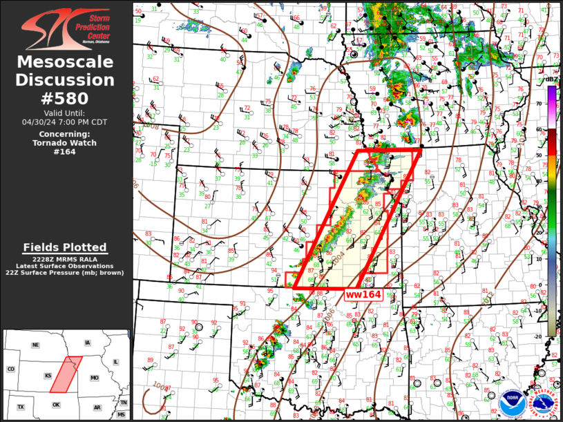
MD 0580 CONCERNING TORNADO WATCH 164… FOR CENTRAL PLAINS
Mesoscale Discussion 0580
NWS Storm Prediction Center Norman OK
0530 PM CDT Tue Apr 30 2024
Areas affected…Central Plains
Concerning…Tornado Watch 164…
Valid 302230Z – 010000Z
The severe weather threat for Tornado Watch 164 continues.
SUMMARY…Severe threat will shift east across ww164 this evening.
New ww will likely be warranted downstream by 23z.
DISCUSSION…Southern influence of northern Plains short-wave trough
appears to be affecting northeast KS into extreme northwest MO early
this evening. Surface front is advancing east with this feature and
currently arcs from western IA-southeast NE-central KS. Numerous
robust updrafts/supercells have evolved along/ahead of this boundary
and large hail appears to be common with most longer-lived updrafts.
Additionally, a few tornadoes have been noted with two long-lived
supercells over northeast KS. Latest VWP data ahead of this activity
is quite strong with 0-3 SRH on the order of 300-400 m2/s2. Tornado
threat continues, along with large hail as this activity propagates
downstream.
..Darrow.. 04/30/2024
…Please see www.spc.noaa.gov for graphic product…
ATTN…WFO…EAX…TSA…OAX…TOP…ICT…OUN…
LAT…LON 36989807 40519604 40529393 36979607 36989807