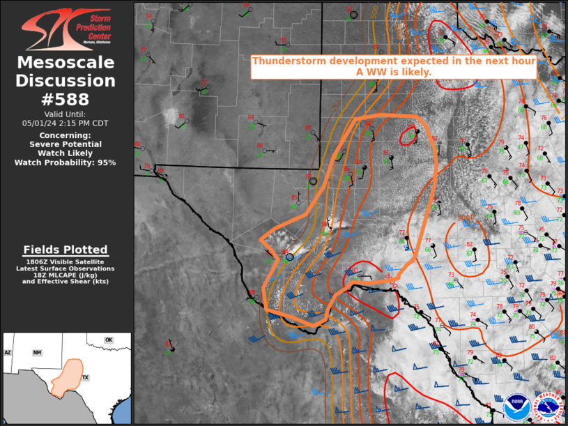
MD 0588 CONCERNING SEVERE POTENTIAL…WATCH LIKELY FOR WEST TEXAS
Mesoscale Discussion 0588
NWS Storm Prediction Center Norman OK
0110 PM CDT Wed May 01 2024
Areas affected…West Texas
Concerning…Severe potential…Watch likely
Valid 011810Z – 011915Z
Probability of Watch Issuance…95 percent
SUMMARY…Widely scattered to scattered thunderstorm development is
expected across portions of west Texas within the next hour. Large
hail exceeding 2 inches in diameter and wind gusts near 70 to 80 mph
are possible. A WW is likely in the next hour.
DISCUSSION…Visible satellite imagery shows increasing deepening
moist convection over the Davis Mountains and Stockton Plateau. A
dryline extends north to south on the western fringe of this current
cumulus, with dew points in the mid to upper 60s east of it. A mid
level shortwave trough evident in water vapor imagery is just
entering Chihuahua Mexico and will enter west TX around 19-20Z.
Initial storms may remain somewhat unorganized given low end
effective shear. However, as the shortwave trough approaches from
the west increasing large scale ascent and stronger flow will
overspread the region, supporting more widespread coverage and
organized updrafts. In addition, latest surface obs/mesoanalysis
indicate MLCAPE of 3000 J/kg will continue to increase through the
late afternoon. Very steep mid level lapse rates (> 8 C) within the
hail growth zone will support very large hail, especially within
discrete supercells. Damaging winds and a tornado or two will also
be possible. A convective watch is likely in the next hour.
..Barnes/Lyons/Hart.. 05/01/2024
…Please see www.spc.noaa.gov for graphic product…
ATTN…WFO…EWX…SJT…LUB…MAF…
LAT…LON 29960154 29900198 29920235 29820248 29690271 29410287
29240290 29120316 29280365 29400415 29810423 30330392
30500406 30690430 30890400 31160335 31680297 32250275
32920228 33000174 32970095 32780075 32340055 32050053
31740058 31410066 30990082 30460100 30320107 30240118
30060137 29990137 29960154
