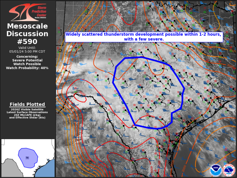
MD 0590 CONCERNING SEVERE POTENTIAL…WATCH POSSIBLE FOR SOUTH CENTRAL TEXAS
Mesoscale Discussion 0590
NWS Storm Prediction Center Norman OK
0333 PM CDT Wed May 01 2024
Areas affected…South central Texas
Concerning…Severe potential…Watch possible
Valid 012033Z – 012200Z
Probability of Watch Issuance…40 percent
SUMMARY…Widely scattered thunderstorms are expected to develop
across portions of south central Texas and the Hill Country within
the next 1 to 2 hours. Very large hail over 2 inches in diameter and
wind gusts exceeding 70 mph could accompany a couple of discrete
supercells.
DISCUSSION…Widespread stratus across most of south central Texas
has been slow to erode through this afternoon. However, visible
satellite imagery indicates some mixing is occurring across the
region where temperatures are already in the mid 70s to low 80s.
This, combined with dew points in the low to mid 70s and steep
(7.5-8 C) mid level lapse rates is yielding 2500-3000 J/kg of
MLCAPE. As an upstream mid level shortwave trough, apparent in
latest WV imagery over southwest Chihuahua Mexico, approaches in the
next 1 to 2 hours mid level ascent should aid in the development of
scattered thunderstorms. Given deep layer effective shear magnitudes
around 50 kt any localized deeper convection could become organized
with a threat of very large hail and damaging wind gusts, though a
lack of additional forcing mechanisms at the surface should limit
the overall coverage of severe thunderstorms. Given the uncertainty
of the coverage, confidence in a weather watch is not particularly
high at this moment.
..Barnes/Lyons/Hart.. 05/01/2024
…Please see www.spc.noaa.gov for graphic product…
ATTN…WFO…HGX…FWD…CRP…EWX…SJT…
LAT…LON 28389814 28429856 28569925 29389969 30420039 31130025
31529979 31589889 31409814 31279765 31189746 30729710
30169673 29909683 29549684 29279692 29089738 28689738
28519762 28419788 28389814
