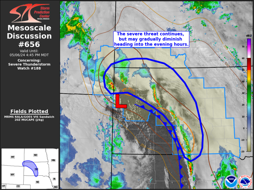
MD 0656 CONCERNING SEVERE THUNDERSTORM WATCH 188… FOR SOUTH-CENTRAL TO NORTHWEST SOUTH DAKOTA
Mesoscale Discussion 0656
NWS Storm Prediction Center Norman OK
0351 PM CDT Mon May 06 2024
Areas affected…South-central to northwest South Dakota
Concerning…Severe Thunderstorm Watch 188…
Valid 062051Z – 062245Z
The severe weather threat for Severe Thunderstorm Watch 188
continues.
SUMMARY…The potential for severe hail/wind continues across
portions of south-central to northwest South Dakota, especially in
the near-term (next 1-2 hours). This threat is expected to gradually
diminish heading into the evening hours.
DISCUSSION…Regional radar imagery and MRMS data over the past hour
continue to show a broken line of strong to severe cells along an
arching cold front from northwest to south-central SD. While many of
these cells have been relatively short-lived after they move off the
initiating boundary, new updraft development is noted within an
environment that remains favorable for organized convection (SBCAPE
between 1000-2000 J/kg with 35-40 knot effective bulk shear). The
expectation for the near-term is for ongoing cells and developing
storms to show periodic intensification to severe limits with an
associated risk of large hail and severe wind gusts. Latest
mesoanalysis suggests ample low-level vorticity continues to reside
along the front with sufficient low-level buoyancy for vertical
stretching (especially where temperatures have warmed into the upper
60s/low 70s) that may support a low-end tornado threat.
Beyond the next 2 hours, the surface low over western SD is expected
to gradually begin occluding with the cessation of northerly
transport of higher theta-e air, effectively isolating the effective
warm front. Early signs of this are already noted with the
development of a line of storms across south-central SD along a more
meridional section of the cold front. With the loss of buoyant
low-level moisture return, convective intensity should gradually
diminish.
..Moore.. 05/06/2024
…Please see www.spc.noaa.gov for graphic product…
ATTN…WFO…ABR…BIS…LBF…UNR…BYZ…
LAT…LON 44770011 44229993 43649981 43219985 42969997 42840018
42760039 42890067 43480100 43960122 44350165 44630217
44880275 45100336 45060388 45040417 45270446 45610453
45780446 46040418 46210354 46260298 46260248 46100161
45890116 45430062 44770011
