
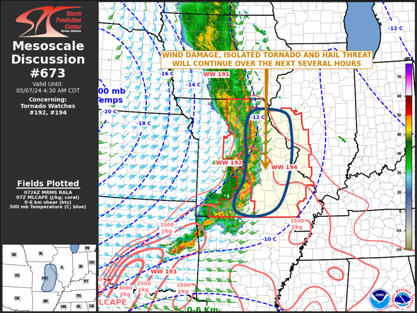
MD 0673 CONCERNING TORNADO WATCH 192…194… FOR MISSOURI…FAR WESTERN ILLINOIS
Mesoscale Discussion 0673
NWS Storm Prediction Center Norman OK
0229 AM CDT Tue May 07 2024
Areas affected…Missouri…Far Western Illinois
Concerning…Tornado Watch 192…194…
Valid 070729Z – 070930Z
The severe weather threat for Tornado Watch 192, 194 continues.
SUMMARY…A potential for wind damage, a few tornadoes, and hail
will continue along a line of strong to severe storms moving through
Missouri. The severe threat will eventually affect parts of western
Illinois later tonight.
DISCUSSION…The latest hi-resolution radar imagery shows a
well-developed severe linear MCS, with several embedded rotating
cells and bowing line segments. This line is moving eastward into
moderate instability, with the RAP analyzing MLCAPE around 1500 J/kg
across much of eastern Missouri. In addition, WSR-88D VWPs ahead of
the line near St Louis have 0-6 km shear near 35 knots, with 0-3 km
storm-relative helicity near 550 m2/s2. This environment will
continue to support a wind damage and isolated tornado threat with
the rotating elements within the line. These stronger cells could
also be associated with hail.
..Broyles.. 05/07/2024
…Please see www.spc.noaa.gov for graphic product…
ATTN…WFO…PAH…ILX…LSX…DVN…SGF…EAX…
LAT…LON 38679245 37789259 37219293 36789296 36579256 36559182
36829110 37509071 38509047 39439045 40089068 40269164
40169223 39759248 39129251 38679245