
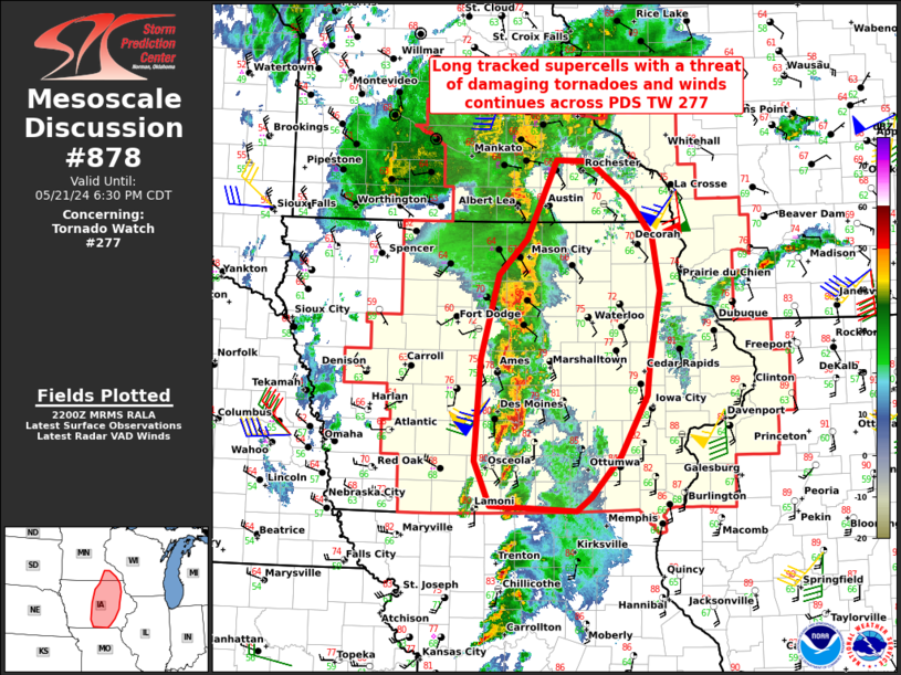
MD 0878 CONCERNING TORNADO WATCH 277… FOR CENTRAL IOWA AND FAR SOUTHEASTERN MINNESOTA
Mesoscale Discussion 0878
NWS Storm Prediction Center Norman OK
0503 PM CDT Tue May 21 2024
Areas affected…Central Iowa and far southeastern Minnesota
Concerning…Tornado Watch 277…
Valid 212203Z – 212330Z
The severe weather threat for Tornado Watch 277 continues.
SUMMARY…Long tracked supercells within a line extending north to
south across central IA will continue to move eastward into an even
more favorable tornadic environment.
DISCUSSION…Ongoing tornadic supercells continue from Cambridge, to
just east of Des Moines. The latest DMX VAD profile data indicates
0-1 km SRH around 100 m2/s2. However, just upstream the DVN VAD
shows SRH is double to triple that. In addition, a corridor of
higher boundary layer moisture and backed surface flow east of the
current line of deep moist convection from around Olmsted County
south-southeastward to Linn County suggests localized SRH should be
maximized there, juxtaposed with maximum buoyancy. Therefore, the
potential for long tracked, damaging tornadoes appears most likely
over the next 1-2 hours as far north as extreme southeastern MN.
..Barnes.. 05/21/2024
…Please see www.spc.noaa.gov for graphic product…
ATTN…WFO…DVN…ARX…MPX…DMX…
LAT…LON 40659371 41099392 42139384 42969359 43329321 44129282
44109237 43739184 43349151 42809142 42109155 41769160
41149196 40749235 40599255 40659371